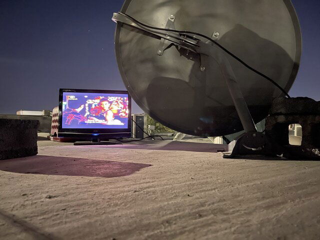
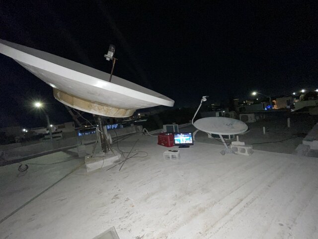
I've had several PMs asking how to do dish aiming when using a dish installation on an inclined pole as pictured in this post.
https://www.satelliteguys.us/xen/threads/how-do-i-get-a-ku-dish-to-point-lower.369079/page-2#post-405964
I can't edit that post, so a bit more detail is given here to maybe help out. Forgive me if it pisses you off.

Utilize an inclinometer or angle measuring app on a phone. These are typically accurate to 1/10th of a degree.
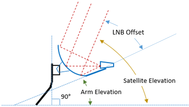
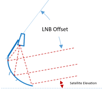
Determine by measuring the angle the LNB arm makes with the horizontal plane when aimed at your southernmost satellite. This is how to measure for any satellite elevation for an installation. The angle measurement stamped on mounting brackets can be confusing or just plain wrong. Say your LNB arm is at 30° when you are aimed at the southernmost sat that is at a satellite elevation or 45°, you set the LNB arm to the angle equal to "Sat Elevation" minus 15°. Just measure one time to figure the correlation of a specific dish's LNB arm angle to the aiming elevation angle. I like to write this angle on the dish with a sharpie so I have it anytime I need to mess with the dish.
It's always advisable to plumb the dish mounting pole to 90° when possible so as you swing a dish to different azimuth angles the LNB polarization or skew angle doesn't get affected too much.
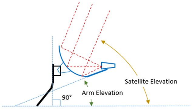
To enable an easier method for experimenting with hitting different satellite orbitals, the offset dish mounting pole can be installed at the angle that corresponds to the latitude of the dish installation. Say you are at 50°N, make the pole angle 50°.
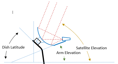
It is important to ensure the pole mounting pivot axis (bolt) is aligned with true east-west and is also level. You can measure from symmetric points on the dish reflector or LNB arm to symmetric points on the mast mounting foot to make them equal. When the symmetric measurements are equal, rotate the foot to get the southernmost satellite in focus. Lock the foot down.
After the mast pivot point is aligned east-west, rotate the mast on the foot pivot bolt until the angle of the mast is equal to the latitude. Now, aim the dish using the LNB arm angle that was determined to hit the southernmost satellite. If you have taken care to be accurate in setting this up, hitting any orbital position is just a matter of rotating the dish on the pole until the satellite comes into view.
If your latitude and specific equipment result in interferences with the LNB arm hitting something because it is too low, you can flip the dish reflector on the mount so the LNB arm is on top of the dish. Just remember that after flipping the dish, you need to determine the new LNB arm angle either by knowing all the design angles and calculating it, or just measure it when pointed at the southernmost satellite.
I can't stress enough to have a working understanding of the different angles involved and how they interrelate. If you have this mental model, you can work successfully through most aiming issues. At some point aiming a dish becomes fairly routine. But you can get rusty after not doing it for a while.
If you're having problems, break it down to the basics. Try to establish landmarks that point to geographic south from the installation location. If magnetic compass points are erratic or difficult to establish, use the sun or moon at the time when they are at geographic south. Look back at the dish location in the evening and use the North Star to draw the north-south line through the dish location. If you're getting confused or want to do a sanity check, ask yourself what the angles would do or look like if you were at the equator or the pole (north or south).
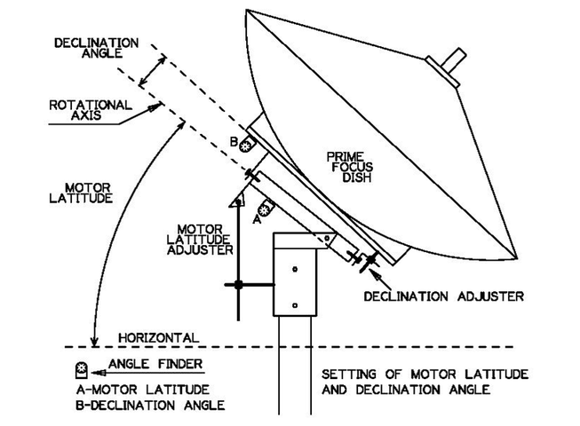
I've had this diagram on my "frequency aiming cheat sheet" and always refer to it to keep my thinking straight. Offset or prime focus principles are using the same angles, but the places where angle measurements are taken can be different and also could be referenced differently (like the elevation stampings on an offset Ku dish).
https://www.satelliteguys.us/xen/threads/how-do-i-get-a-ku-dish-to-point-lower.369079/page-2#post-405964
I can't edit that post, so a bit more detail is given here to maybe help out. Forgive me if it pisses you off.
Utilize an inclinometer or angle measuring app on a phone. These are typically accurate to 1/10th of a degree.
Determine by measuring the angle the LNB arm makes with the horizontal plane when aimed at your southernmost satellite. This is how to measure for any satellite elevation for an installation. The angle measurement stamped on mounting brackets can be confusing or just plain wrong. Say your LNB arm is at 30° when you are aimed at the southernmost sat that is at a satellite elevation or 45°, you set the LNB arm to the angle equal to "Sat Elevation" minus 15°. Just measure one time to figure the correlation of a specific dish's LNB arm angle to the aiming elevation angle. I like to write this angle on the dish with a sharpie so I have it anytime I need to mess with the dish.
It's always advisable to plumb the dish mounting pole to 90° when possible so as you swing a dish to different azimuth angles the LNB polarization or skew angle doesn't get affected too much.

To enable an easier method for experimenting with hitting different satellite orbitals, the offset dish mounting pole can be installed at the angle that corresponds to the latitude of the dish installation. Say you are at 50°N, make the pole angle 50°.

It is important to ensure the pole mounting pivot axis (bolt) is aligned with true east-west and is also level. You can measure from symmetric points on the dish reflector or LNB arm to symmetric points on the mast mounting foot to make them equal. When the symmetric measurements are equal, rotate the foot to get the southernmost satellite in focus. Lock the foot down.
After the mast pivot point is aligned east-west, rotate the mast on the foot pivot bolt until the angle of the mast is equal to the latitude. Now, aim the dish using the LNB arm angle that was determined to hit the southernmost satellite. If you have taken care to be accurate in setting this up, hitting any orbital position is just a matter of rotating the dish on the pole until the satellite comes into view.
If your latitude and specific equipment result in interferences with the LNB arm hitting something because it is too low, you can flip the dish reflector on the mount so the LNB arm is on top of the dish. Just remember that after flipping the dish, you need to determine the new LNB arm angle either by knowing all the design angles and calculating it, or just measure it when pointed at the southernmost satellite.
I can't stress enough to have a working understanding of the different angles involved and how they interrelate. If you have this mental model, you can work successfully through most aiming issues. At some point aiming a dish becomes fairly routine. But you can get rusty after not doing it for a while.
If you're having problems, break it down to the basics. Try to establish landmarks that point to geographic south from the installation location. If magnetic compass points are erratic or difficult to establish, use the sun or moon at the time when they are at geographic south. Look back at the dish location in the evening and use the North Star to draw the north-south line through the dish location. If you're getting confused or want to do a sanity check, ask yourself what the angles would do or look like if you were at the equator or the pole (north or south).
I've had this diagram on my "frequency aiming cheat sheet" and always refer to it to keep my thinking straight. Offset or prime focus principles are using the same angles, but the places where angle measurements are taken can be different and also could be referenced differently (like the elevation stampings on an offset Ku dish).


