Azimuth Question??

Status
Please reply by conversation.

esteveW

SatelliteGuys Pro
Original poster
Dec 10, 2008
166
0
Western WA
I'm getting ready to set the 3" pipe post for my 10' BUD. I started surveying my 1 acre lot for a location that would the best, clear view of the east and southern sky.
I'm located in the Pacific NW at about Lat. 47 and ~ Longitude 123. I did a site search for this location and know which satellites can be seen (assuming no trees or structures block the sky).
I started plotting the most promising location and noting the one major tree. It being due east of this spot. It's about 70' tall. I started trying to plot the various satellites available for this size dish.
Maybe I don't understand the satellite ID or number/name system. I had assumed the number was the true bearing but now realize this must be the Longitude. Is this correct??
If so, what kinda spherical trig am I going to have to use to get a true bearing from my location to the Longitude of the Sat.????
The dish setup procedure that I have read assumes I have the dish and motor already mounted on the post. I need to map several post locations to see which can best "see around" the problem tree(s) (mine and the nearby neighbors).

There must be a calulator to do this, from a site survey stand point.

Thanks,

Steve
 
I had assumed the number was the true bearing but now realize this must be the Longitude. Is this correct?
Yes, Sat are positioned according to Latitude.
If so, what kinda spherical trig am I going to have to use to get a true bearing from my location to the Longitude of the Sat.????
Go to....
Satellite Look Angles Satellite Heading Calculator Azimuth Elevation Skew Tilt LNBF Latitude and Longitude values
Enter your location, and select "True South / True North" then click "Go"
 
Another webfoot !

esteveW

Don't forget that we have about 21° of magnetic deviation in these parts so your compass needle will not be pointing to true (polar) north.

G18 is pretty much due south at 123° so if you tune in on that you will be in good shape. (It has nice KU too)
 
Azimuth question

Thanks for the tips and Link to the calculator. Works great and I have already developed a Table of the most interesting C band sats. The true bearings look encouraging for my preferred spot. I'm fortunate that my property lines run on true north/south and east/west directions. I also have a hand bearing compass from my boat (seldom gets used since I do most plotting on radar or chart plotter).

I see large extremes in the Elevation and wonder how most deal with changing this since my dish (and most I see) have only manual adjusting screws. Is this ever motorized??

Now back to my plots on a drawing of my lot and all the local trees and tall structures.

BTW: Someplace I read that C band (BUDs) can get a useable signal through tree follage. Any truth to this (before I take the chainsaw to some neighborhood trees)??

Thanks again,

Steve
 
Its probably motorized if it has a polar mount. The actuator (motor) would look like a long automotive shock absorber. Send us pictures if you are not sure what you've got.

I just installed a motorized 10' Unimesh. I replaced the old actuator and got a GBox V3000 to control it. Having a motorized setup to track the entire satellite arc is very convenient -- well worth the $180 I spent getting them from Sadoun. But it took many attempts and small adjustments to get it tracking the entire arc.

As for getting signal through trees -- mine works OK through my neighbors tree with fairly dense branches, but its now leafless. Don't know if it will still work in the spring when the leaves return.

I wasted money on a new BSC621-2 C/KU LNB since the mesh does not work with KU band, but I'm happy with its C-band performance.
 
Azimuth question

My BUD is a 10' KualTronic and is motorized for the east/west arc. It is the elevation that I'm wondering about since list of satellites I "can see" have elevations from (w177) 15.6 deg. to (w123) 36 deg. to (w58) 7.8 deg, .. Now I might never see the 15.6 or (definately) not the 7.8 since there are several single story houses in that direction. I suspect that a elevation of about 36 deg. from the horizon is what it is set at now, since it origanally came from this area and that would come close to (5 deg.) the majority of the K-u and most popular satellites.

I'm supprised to read your comment about the mesh dish not getting K-u band. My dish is mesh and came with both C-band and K-u band LNBs, as well as a polarity servo. The wave guide/mount is Chaparral, OEM installed on a button hook mount. The fellow I got the BUD from knew even less than I about it since it was there when he bought the property 15 years ago. He had been using it for all this time, until the trees next door got to tall and dense. I didn't get any of the controls or sat box etc., but it sounded like he was getting K-u band but didn't seem to admit what bands or satellites he was getting. However, his new dish was a 20" DN.

If necassary, I will add motorized drive to the elevation adjustment if preliminary manual tests indicate it will provide sat.s at the extreme lower elevation.

I posted some pictures of my BUD last month, however, it was and still is disassembled. This last week, I finally found a 12' length of 'scrap' 3" ips pipe for my mount pole. (new pipe was going to cost about $9/ft. The scap yard charge me $20 total.)

Thanks for your response and information on how you are dealing with the installation of (similar) 10' mesh BUD.

Steve
 
Last edited:
It is the elevation that I'm wondering about since list of satellites I "can see" have elevations

As Greg said, you set-up to your True South Sat, the Sat on the same Longitude to where you live. Then as the Dish moves East / West, the elevation will change just by the mechanics of the mount.
 
I'm not sure what the "Sorry" refers to. I appreciate all of your comments. I have been reading the last Link with too much info to absorb between posts.
I am slowly gathering more enough knowledge to realize my first and second post were somewhat misinformed.

Don't hesitate to tell me so.

Steve
 
A "handy" way of estimating degrees of elevation is to hold your arm out in front of you in a horizontal position. Your fist (pinky to thumb) will cover about 10 degrees. Extend your index finger and it will be covering about 2 degrees. By stacking these body metrics you can get a pretty good idea if an object along any given compass bearing is going to impact your line of sight.

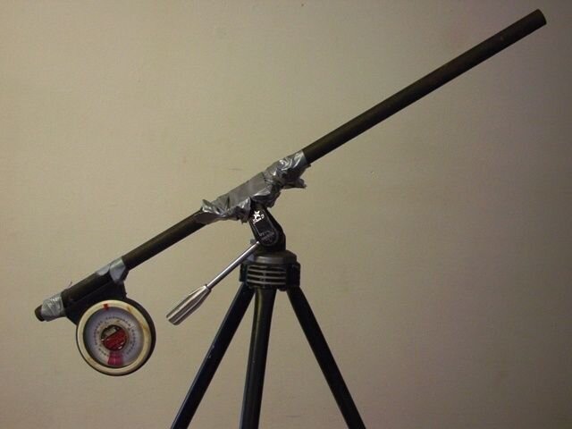
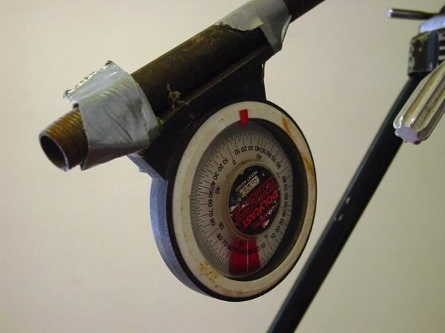
However, if there is still some doubt, you can cobble together a boresight/inclinometer using materials you may already have on hand - a picture is worth a thousand words, images attached.
 

Attachments

  • Inclinometer01.JPG
    Inclinometer01.JPG
    25.2 KB · Views: 165
  • Inclinometer02.JPG
    Inclinometer02.JPG
    31.7 KB · Views: 158
Ah
Sort of a Red Green duct tape approach :D
Good idea
If you don't have a inclinometer (you should get one) you can use a protractor (the plastic kind that looks like a VW or the back of a turtle) and a string with a little weight attached
 
I highly recommend the Sears Craftsman 10 in. Digital LaserTrac® Level. You can set the elevation to within 1/10 of a degree.

To get your dish tracking the arc, you need to set the actuator arm so that the dish is at its max elevation on the polar mount. This is important because the dish must be at its peak elevation exactly when its pointing perfectly south.

You'll need to set the declination to about 6 degrees, which should be pretty close for your location. The declination is the angle between your dish and the polar axis. This small angle is what keeps your dish from pointing out into deep space. The TV satellites are 22,000 miles away, so your height above the equator is significant in determining the declination angle.

The numbers produced by the online satellite azimuth/elevation calculators already take this declination angle into account, so they indicate the elevation of the dish, not the polar axis.

Once you have the declination angle set and the dish at is highest point on the axis mount, you should aim it due south by peaking it on 123W.

After you have it peaked for 123W, you can move the actuator and see if some of the satellites to the east and west are properly tracked. It took some trial and error for me to get mine to track the entire arc.
 
I went to the Sears page and read the reviews and some of them are not too flattering.
One of the reviewers recommended the The Wixey Digital Angle Gauge.
I have neither so I can't give a first hand account


Wixey Digital Angle Gauge


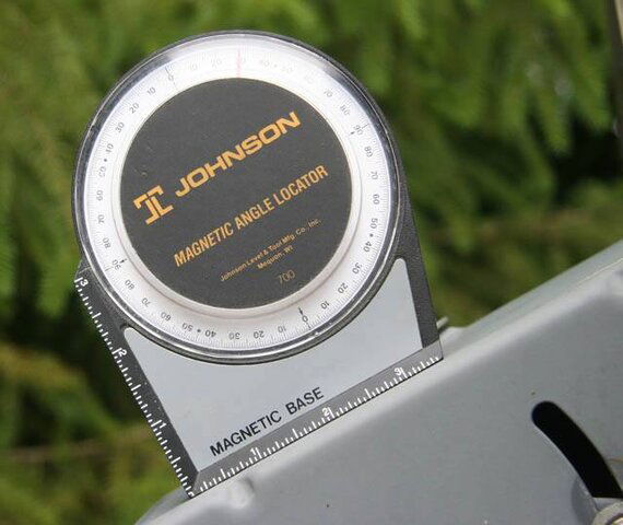
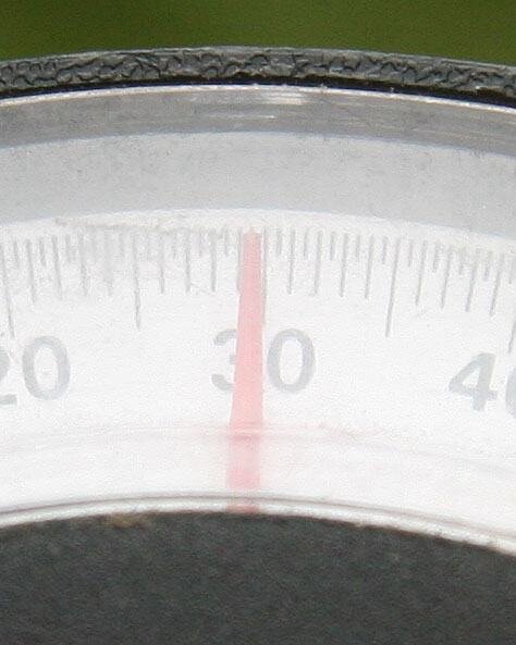
I use the cheap kind. It's pretty accurate...mostly
 

Attachments

  • inclinometer1.jpg
    inclinometer1.jpg
    38 KB · Views: 153
  • inclinometer2.jpg
    inclinometer2.jpg
    34.6 KB · Views: 155
Last edited:
I went to the Sears page and read the reviews and some of them are not too flattering.
The first 3 reviews are not encouraging, but they are followed by 11 very positive reviews.

Without the 0.1 degree accuracy of the Craftsman Level, I would probably never have been able to align my dish to the satellite arc.
 
I highly recommend the Sears Craftsman 10 in. Digital LaserTrac® Level. You can set the elevation to within 1/10 of a degree.
Thanks. I've been looking for one of those things for a long time. Looks like that should work well. I just ordered one.
Not much detail on it at the Sears site though. I saw mentioned that it saves something like 9 measurements. Is there a button or something that allows you to store a measurement? If so, it would be pretty useful for site evaluations too. I usually hold one of those inclinometers up, moving my head around to the side to see what it's reading, and it changes by the time I do that, but with this thing, if you can sight it at the top of a tree, and push a button, then look at the reading you've stored, that would be nice. I guess I'll find out when it comes. I know that there are those all in one devices that have compass and inclinometer that show up in the viewfinder, but those are kind of expensive. I've made those home-made things too, with a protractor and string/weight. That works OK too, but it gets torn apart in my junk drawer.

I also have one of those Arc-Set (I think that's the name) things that used to be sold by Gourmet Entertainment. I got mine used, so it wasn't calibrated for my location, so I calibrated mine on a dish that I've already aligned, and then used it to align another dish. Those work well too. The above digital level might provide a way of calibrating one of the Arc-Set devices.
 
Well if there is no wind, a plumb bob also works for plumbing up a mast, unless you have to have all the latest electronic toys, that is. I've used a standard carpenter's level with good results. I think I have to see a bubble.rather than trusting my project to some kind of spooky electronic magic.

Fortunately you are a 123 west longitude. That lines you up with a satellite that has (last I checked) both Ku and C on it. Your dish high point should hit it if your elevation/declination is good. You will have some declination at that latitude.

I like using a "beep to scan" fta receiver and wireless radio headphones. I set the receiver on the due south satellite, on a hot transponder, and, as you move the dish around and up and down, you'll get it beeping. The most, highest pitched beeps means it's aimed .

Good luck.

Big dish rules.
 
Thanks. I've been looking for one of those things for a long time. Looks like that should work well. I just ordered one.
Not much detail on it at the Sears site though. I saw mentioned that it saves something like 9 measurements. Is there a button or something that allows you to store a measurement?.
Yes, you can press the 'Hold' button to freeze the display and store a measurement. Once you let go of the 'Hold' button, the display will resume its updates. And you can press 'Memory Recall' at any time to look at stored values.
If so, it would be pretty useful for site evaluations too. I usually hold one of those inclinometers up, moving my head around to the side to see what it's reading, and it changes by the time I do that, but with this thing, if you can sight it at the top of a tree, and push a button, then look at the reading you've stored, that would be nice. I guess I'll find out when it comes.
Yes, its great for site evaluations. No more wondering 'If I put the Dish here, will it clear that tree?' The red laser is quite strong and visible at a distance in daylight. Just aim it at the top of the tree/building in question, press 'Hold' and you will know if the satellite is above or below it.
I know that there are those all in one devices that have compass and inclinometer that show up in the viewfinder, but those are kind of expensive. I've made those home-made things too, with a protractor and string/weight. That works OK too, but it gets torn apart in my junk drawer.
My first attempt to measure the inclination angle was with a standard bubble level and a protractor. Didn't work too well. This Sears Digital Level even tells you the temperature when you first turn it on!

For satellite aiming use, there is only one downside to this device. If you set the long side of the level against the dish, you have to subtract the reading you get from 90 to get the elevation. Either that or you can set one of the short ends of the level against the dish and get a direct elevation reading, but it probably would be a little less accurate.

Another cool feature is that if you turn the level upside down, the display reading flips over so you can read it.

Needless to say, I am extremely pleased with my purchase and impressed by all the thought that went into the device.
 
Status
Please reply by conversation.

Getting 922 battery worries

Setting up FTA to Bud with analog receiver

Users Who Are Viewing This Thread (Total: 0, Members: 0, Guests: 0)

Who Read This Thread (Total Members: 1)