Dish New FCC Filings on Ciel-2 Satellite

Are those three separate spot beams ? Currently those are all on one spot for SD channels (110) and another for HD channels (119).

SF to Oakland is something like 10 miles as the crow flies...

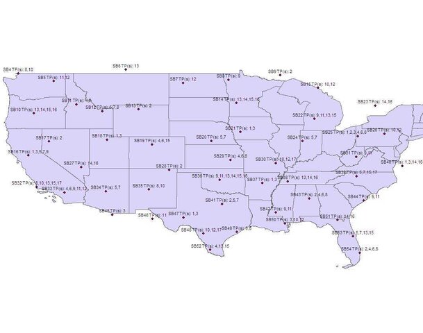
The table is just the listing provided in the narrative.

I'm just starting work on the tech details.
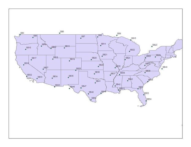
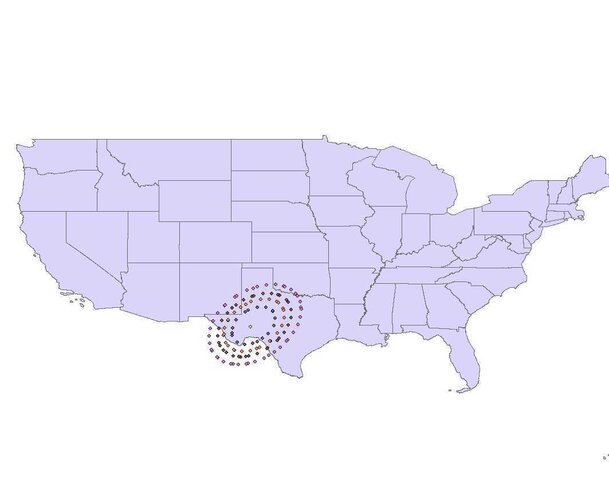
 
Edited quote...

A small start

Spot Beam Cities for Ciel 2 at 129W

8PSK Turbo 2/3

ATLANTA GA
NASHVILLE TN
SHREVEPORT LA
WASHINGTON DC
HAGERSTOWN MD
CLEVELAND OH
AKRON OH
CANTON OH
CHICAGO IL
MARQUETTE MI
INDIANAPOLIS IA
==================================
QPSK Turbo 5/6

TAMPA FL
ST PETERSBURG FL
SARASOTA FL
CHARLESTON SC
NEW ORLEANS LA

I'm surprised to see so many Eastern cities, including my own town of Cleveland, which has never had locals on 129. It seems early next year, several Eastern Arc cities will have the option of eastern or western arcs and still be able to deliver HD locals.

Also, Cleveland, Akron, and Canton are all part of the same DMA. Odd they would have their own spots given they will have the same channels. Is there some kind on new payload on Ciel-2 with much tighter spots?
 
When I first looked at those lists of cities, I thought they must be center-of-beam sites. But "after further review," I think they must just be "representative" locations shown to illustrate typical expected signal strengths in various areas. It is curious, as HDRoberts pointed out, that there are as many eastern cities on the list as there are.

Brad

That is how I interpreted it when I first saw it. Notice there are no cities listed in the Northeast U.S. Looks like a line from Cleveland/Akron/Canton down to Washington, DC is the limit of coverage. As I have pointed out in other threads, I don't expect clean lines of demarcation between Eastern Arc and Western Arc, it will depend on where Dish has spotbeam capacity to determine which Arc a specific city is on in overlapping areas. Certainly folks in the Northeast U.S. will be on the Eastern Arc and folks on in the West will be on the Western Arc but in between it could be either.

As a side note, Dish will receive a fee waiver from the FCC and not have to pay $850 million for the 5 million customers using the Ciel-2 satellite.
 
Yeah, $850M would put quite a dent in operations. Let's see, 850M/14M is a bit over $60. Call it a $6/month "Ciel availability fee?"
 
Forgive the crudeness of this. This is my first go at this and I lack the tool to quicky turn the points into lines. Here is the CONUS coverage, dilenated by the gain field under beam contour.
 

Attachments

  • Ciel2CONUS.jpg
    Ciel2CONUS.jpg
    45.9 KB · Views: 284
Patience on the beams. It it time consuming but I will have all the Ciel footprints out - including spots- in a few days. Have found a nice site in Europe which has been helping by converting my google earth kml's into a standard google map format and hosting in their satellite database for public access. I'll get some snapshots posted for an early peak while data processing continues.
 
Here is SB25, just to give you an idea. It looks centered on Youngstown/Pittsburgh, 2 cities not even mentioned above.

I'm using ArcGIS, but I need the spactial analyst extention to turn the points into proper contours. Maybe I'll break out the 60 day trial I have at home that includes all extentions. Or, maybe I'll just wait for nelson61 to do the gruntwork.:D

Interestingly, SB23 looked focused on Toronto, not containing much of the US. I wonder how much the Canadians plan on using this bird. That could have bad implications for us, given the comparitively low power of this bird.
 

Attachments

  • ciel2SB25.jpg
    ciel2SB25.jpg
    28.1 KB · Views: 200
Here is SB25, just to give you an idea. It looks centered on Youngstown/Pittsburgh, 2 cities not even mentioned above.

I'm using ArcGIS, but I need the spactial analyst extention to turn the points into proper contours. Maybe I'll break out the 60 day trial I have at home that includes all extentions. Or, maybe I'll just wait for nelson61 to do the gruntwork.:D

Interestingly, SB23 looked focused on Toronto, not containing much of the US. I wonder how much the Canadians plan on using this bird. That could have bad implications for us, given the comparitively low power of this bird.

I would not worry too much about Canadian spotbeams and power because the all the spotbeams do not have to be used and probably will not initially be used because much of the satellite power will be needed for the CONUS TPs. Also realize that some of the spotbeams may have been created as backups for the spotbeams from E-10 at 110 W. They also maybe planned to be used for smaller DMAs.
 
One last map, the center off all the spots.

Note: Alaska (SB1) and Hawaii (SB55) are not included. The Alaska beam seems to have a dual focus, primarily on Anchorage, with a secondary area around Juneau. There are no spots numbered 2 or 3.
 

Attachments

  • ciel2-spotcenters.jpg
    ciel2-spotcenters.jpg
    33.9 KB · Views: 622
While I do not know what plans Ceil has in mind for Ceil-2 under Canadian law 50% of the capacity has to be reserved for Canadian use. If there are no Canadian takers then Ceil can lease more of the capacity. Maybe Ceil plans on leasing some space to Bell TV.
 
Are they going to use 2 different spotbeams for Tacoma and Seattle? That'd be weird, since they're only about 25 miles apart, and about another 15-20 miles down here to Olympia. Spokane is on the eastern side of the state, about 350 miles ENE of here.

That list doesn't correspond to spotbeam centers. There is only one beam, SB4 in the filing, centered on the SeaTac area.
 
While I do not know what plans Ceil has in mind for Ceil-2 under Canadian law 50% of the capacity has to be reserved for Canadian use. If there are no Canadian takers then Ceil can lease more of the capacity. Maybe Ceil plans on leasing some space to Bell TV.

I doubt it. Dish is leasing space at 72.7 W with Bell TV which is a much better CON-Canada location than 129 W. (Bell TV had leased all of Nimiq 5 from Telesat, the owner of Nimiq 5 which will repalce the E-6 satellite there when launched in early 2010) I suspect that the agreement between Dish and Bell TV included not only the 16 TPs at 72.7 W and the deal on the Dish satellite receivers (Bell TV uses Dish satellites receivers) but also an agreement on usage or non-usage of TPs on Ciel-2.
 
Say What ?

One last map, the center off all the spots.

Note: Alaska (SB1) and Hawaii (SB55) are not included. The Alaska beam seems to have a dual focus, primarily on Anchorage, with a secondary area around Juneau. There are no spots numbered 2 or 3.

Sorry but don't understand the focus of SB47 it is in the middle of no where. It is NE of Presidio, TX. S of Midland/Odessa & way the heck W of San Antonio. In short why are they trying to burn a hole in the deer, goats & cattle that inhabit that area?:D
 
One last map, the center off all the spots.

Note: Alaska (SB1) and Hawaii (SB55) are not included. The Alaska beam seems to have a dual focus, primarily on Anchorage, with a secondary area around Juneau. There are no spots numbered 2 or 3.

Could SB2 and SB3 be the CONUS and CON-Canada beams?
 
Could SB2 and SB3 be the CONUS and CON-Canada beams?

It seems to me they are refering to the CONUS and CONCanada beams as "CAN7" and "CAN4" respectivly. That, or I'm missinterpeting things. This is my first go at interpeting a FCC Schedule S.:) Perhaps there were some addtional Canadian spots in the design, but were scrapped. The numbering is Right to Left, North to South. That would place Canada is the spots for SB2 and SB3, given Alaska as SB1 and Seattle as SB4.
 
Sorry but don't understand the focus of SB47 it is in the middle of no where. It is NE of Presidio, TX. S of Midland/Odessa & way the heck W of San Antonio. In short why are they trying to burn a hole in the deer, goats & cattle that inhabit that area?:D

Perhaps a picture of the entire beam will help. I don't know my Texas geography, but there has to be some people covered by that.
 

Attachments

  • ciel2SB47.jpg
    ciel2SB47.jpg
    27.3 KB · Views: 198
Perhaps a picture of the entire beam will help. I don't know my Texas geography, but there has to be some people covered by that.
Midland/Odessa, Abilene, San Angelo, Lubbock maybe. Amarillo and El Paso would be on the far fringes.

But I think some of the spotbeam centers are skewed. The Texas spots don't make a lot of sense, other than Houston and Dallas/FTW.
 
For what it's worth, here is a map with the spot centers and what TPs feed them. The centers may be slighly skewed. The points are in lat/lon and my US map is based on NAD83 coordiantes. If you no GIS, you will understand. Also, as you can see from this map, many of the middle of nowhere spots are fed by only 1 or 2 TPs. That makes more sense.
 

Attachments

  • ciel2-spotcenterswithTPs.jpg
    ciel2-spotcenterswithTPs.jpg
    44.1 KB · Views: 242

Users Who Are Viewing This Thread (Total: 0, Members: 0, Guests: 0)

Who Read This Thread (Total Members: 2)

Latest posts