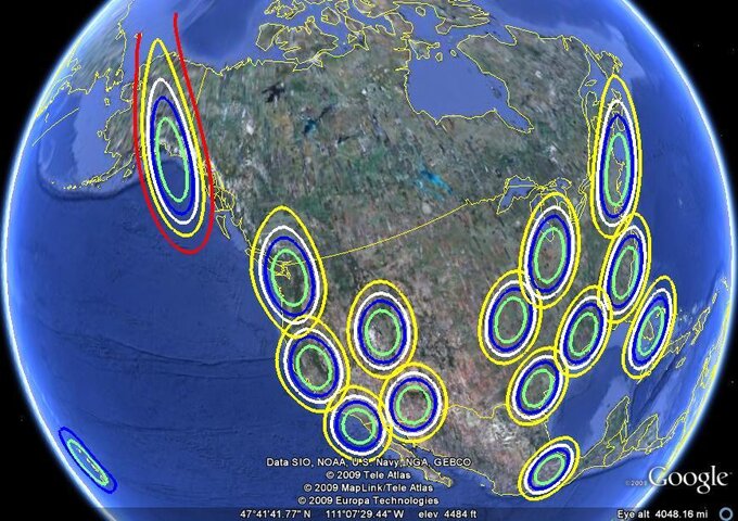
Echostar 7 119W Spotbeam Maps

  • WELCOME TO THE NEW SERVER!

    If you are seeing this you are on our new server WELCOME HOME!

    While the new server is online Scott is still working on the backend including the cachine. But the site is usable while the work is being completes!

    Thank you for your patience and again WELCOME HOME!

    CLICK THE X IN THE TOP RIGHT CORNER OF THE BOX TO DISMISS THIS MESSAGE
The North American beam map of the 15 E7 spotbeams.
 

Attachments

  • Echostar 7 Spotbeams.jpg
    Echostar 7 Spotbeams.jpg
    124.5 KB · Views: 588
Nice map. If you compare the E-7 spotbeams to those of E-10, E-12 or Ciel-2, one can see how far the capabilities have progressed in the last 8 - 10 years.
 
Nice map. If you compare the E-7 spotbeams to those of E-10, E-12 or Ciel-2, one can see how far the capabilities have progressed in the last 8 - 10 years.

Not really.

E* skimped on the spot beam on E7 and E8 because of Charlie's shortsightedness.
DirecTV spotbeam birds built and launched around the same time as E7 and E8 have more beams than E7 and E8.
 
Not really.

E* skimped on the spot beam on E7 and E8 because of Charlie's shortsightedness.
DirecTV spotbeam birds built and launched around the same time as E7 and E8 have more beams than E7 and E8.

E7 was designed with only 2 uplink centers in mind is why.
 
Question: Is there a rough dish size for the green circle and for the yellow circle ?

Amazingly, some DMAs are partially outside the green circle.

PS If they can be re-done with a little more space around the yellow circle, and without the copyright text, NOAA text, etc. etc. that would be helpful (although I could understand that the latter may not be possible).
 
These maps are designed with a typical DishNetwork installation in mind. Yellow circle works just fine.

If I zoom out any farther it loses the details of interstates and such which helps people figure out where they are at on the map.
 
These maps are designed with a typical DishNetwork installation in mind. Yellow circle works just fine.

If I zoom out any farther it loses the details of interstates and such which helps people figure out where they are at on the map.

But the 3 or 4 rows of type along the bottom do the same thing.

Perhaps an extra set could be made that zoom out enough to put the type outside of the yellow circle ?
 

Users Who Are Viewing This Thread (Total: 0, Members: 0, Guests: 0)

Who Read This Thread (Total Members: 1)