Need Help with Elevation Degree for New Cband setup

  • WELCOME TO THE NEW SERVER!

    If you are seeing this you are on our new server WELCOME HOME!

    While the new server is online Scott is still working on the backend including the cachine. But the site is usable while the work is being completes!

    Thank you for your patience and again WELCOME HOME!

    CLICK THE X IN THE TOP RIGHT CORNER OF THE BOX TO DISMISS THIS MESSAGE
Status
Please reply by conversation.

cheetah85

Member
Original poster
Jan 16, 2012
6
0
Southern West Virgina
Hello Everyone.

I am in the process of setting up my new WSI 6'ft dish and am kinda stuck. I have mounted the dish to the pole and am confused as to what elevation angle to set the dish at.

The more I read about it the more confused I become. My Lattitude is 36.7 degrees. My true south satellite is 83w. A chart that I seen on another website said to set the elevation at 37.63 degrees plus 5 degrees which would put it at approximately 42 degrees.

Also, once I set it at the correct elevation angle, what declination angle do i set it at.

I am going to keep it stationary on 99w for a couple of weeks until I get the time to install my acuator and vbox.

I hate to pester you guys but I am a certified Newbie when it comes to Cband, but am very familiar with KU d a 36" WS9036 dish and motor.

Maybe you guys can direct me to another thread on this site that can help me out.

Any help would be greatly appreciated.


Thanks,

Keith Brown
Jesse, West Virginia 24849

See here, here and here for some info.
 
I don't know your dish, but generally speaking, you set the declination first, then forget about it. Generally, the polar mount will have an elevation, whatever it may be, and the dish itself is aimed five degrees or so lower than that. I think there are different settings for declination, all around the five degree mark. My latitude is near yours and my Birdview is set at five degrees. I hit everything from 55.5 w to 139 w.

You get your dish to zenith first, and set your declination. Then unless you are dead on your due south satellite longitude, you do a "click" or two in that direction. Then you leave all of that alone and the only things you adjust are moving the dish around the pole and elevation. I personally have never once used an inclinometer to aim a dish.

I like the method of setting with a "beep on scan" receiver and wireless radio headphones. The Manhattan receiver has an function that can be used.

Basically, you buy radio frequency wireless headphones - about fifteen bucks here, and you hook the transmitter of the headphones to the audio out on the receiver. You set the receiver to your due south satellite with all the correct settings for your lnb and C band. You set your receiver to a hot transponder.
Then you verify with your headphones that you are receiving the beep or tone.

Then you go to your dish on a calm and not windy day, and you move your dish around and up and down until your headphones respond.

I know some people have to do math, but I would rather work off of the actual position in the sky.

Good luck
 
There should be some sites with calculators on the declination for your latitude. Like Lone said, that is usually set at the start and left alone, in fact if you're very close on the elevation and azimuth (east,west orientation) you can usually get your c-band dish tracking very well. A tip though-those angle-meters really are worth the ten bucks or so, can put you really close on setting your elevation. And checking your declination setting also. From experiences I've had, setting up a small dish is tougher than a 10-12' dish, your mileage may vary.
 
Although I have used an inclinometer to set declination, I don't think the tool is useful for elevation. First of all, unless the inclinometer is pointed directly up and down (not a perfectly easy thing to do on the front of a satellite dish) it isn't going to be exact. Secondly, newbies especially have trouble figuring out how to read the scales.

I think it is sufficient to say that the dish is aimed about halfway between the horizon and straight up. If you want to use an instrument, I think a good compass can also approximate the dish position - again, not easy to precisely aim the dish, but good for getting it approximately close.

After that, I support working directly off of the due south satellite signal.
 
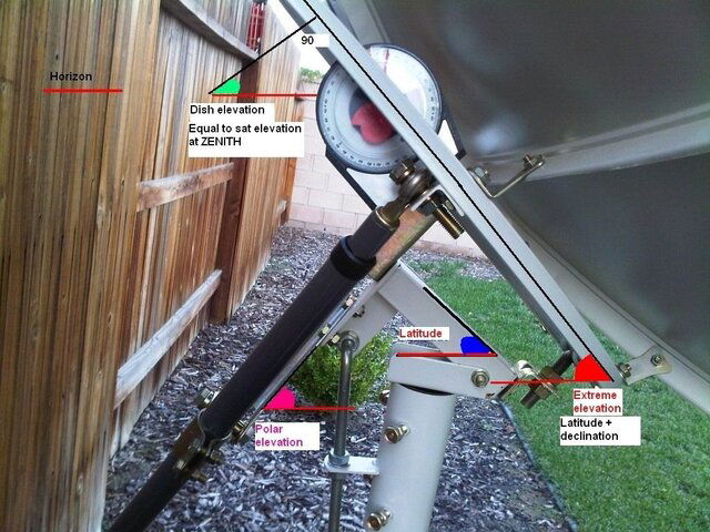
I'll just throw this picture in for reference. (see attachment) Look up your declination on the 2nd chart here: Footprints by Dish Size - Latitude Declination Chart - C/Ku-Band Satellite Listing (labeled "declination offset) Your polar mount Latitude angle(in the picture attached) is labeled elevation angle on the chart. (it's NOT the elevation of your Zenith satellite, explained below)
Just for giggles, I like numbers. Lat= 36.7° (I'll round to 37) Chart says 5.28° declination(closest to actual) Polar mount Latitude angle from chart 37.63 (closest to actual) Since we estimated to the high side, and these angles are 2 digits, I'm going to drop the 2nd digit. and use 5.2° for declination and 37.6° for out polar mount Latitude angle. 37.6(polar mount lat. angle) + 5.2(declination) = 42.8(angle of the dish face or the mount ring on the back). To calculate how far above the south horizon, at zenith, the dish is aiming, we calculate the perpendicular of the dish face- 90 - 42.8 = 47.2°
Dishpointer puts zenith, at 36.7° latitude, at 47.4° (180° Azimuth) .2 off, NICE.
I'd use an inclinometer to set the angles with the dish at it's highest, Pan the mount E-W* on the pole to find Q on the satellite closest to south, and touch-up the Latitude angle. Then continue to setting the Azimuth. *when adjusting the dish, make small corrections, and wait for the receiver to lock onto, or settle, the Q reading. They are not instantaneous.
 

Attachments

  • polar_mount_pic.jpg
    polar_mount_pic.jpg
    152.6 KB · Views: 590
Status
Please reply by conversation.