Parameters for Shaw direct dish in Hartford Area :

  • WELCOME TO THE NEW SERVER!

    If you are seeing this you are on our new server WELCOME HOME!

    While the new server is online Scott is still working on the backend including the cachine. But the site is usable while the work is being completes!

    Thank you for your patience and again WELCOME HOME!

    CLICK THE X IN THE TOP RIGHT CORNER OF THE BOX TO DISMISS THIS MESSAGE

admiraldaala

Member
Original poster
Jun 29, 2022
5
0
Anover Ct
My dish was moved when we had the roof re shingled at the beginning of June. I have tried to aim it again but am unable to get a clean signal. I have gone to three different sights to calculate aiming at F1-F1R but strength is still under 40. Tree tops have leafed out and so I am not sure if those distant trees are blocking or if parameters are wrong. I attached a photo taken with my cell phone on the dish to show its view.

ele 30.4
true asz 226
skew 32.4
magn az 1225

orbit 107W
 

Attachments

  • viewfrom dish.jpg
    viewfrom dish.jpg
    7.7 KB · Views: 153
Is this an FTA dish or a Shaw dish? Shaw Direct uses Anik G1 at 107.3W and Anik F2 at 111.1W. Both Anik F1 and Anik F1R have been removed from Shaw service for a while now.

Did you try DishPointer - Align your satellite dish ? It takes all the guesswork of your precise location (using Google Maps) as well as doing all of the useful calculations for a multi-slot dish. As a starting point, Anover, CT (near the intersection of Center St. and Hebron Rd.) gives these results:

True: 228.4W
Mag: 242.1W
Elev: 29.1
Skew: 120.1 (30.1 for dishes that measure from vertical)

You can move the "pin" in dishpointer to the location of your dish (you probably need to zoom in).

Dishpointer says that your elevation anywhere in the greater Anover area should be 29.1 degrees. 30 degrees would be Danbury.

Your true and magnetic azimuth should be at least 13 degrees apart so I further suspicion your assembled aiming data is garbage. The true azimuth, elevation and skew will never change but the magnetic azimuth will change with your magnetic declination (the current difference of the Magnetic North Pole relative to True North).
 
You may be aware that Anik F1R has reached end-of-life and has been decommissioned. Shaw's replacement satellite located at the 107.3W slot is Anik G1. Anik G1 only covers the northern part of the US and Canada, so you may be able to received it in Hartford.

That being said, when pointing your dish, use the data for Anik F2 and point the Sat B (as labelled on the LNB) side of the LNB to Anik F2 (not F1-F1R as you stated above). Once you have successfully pointed at F2 and if you have the skew/elevation properly set, Anik G1 will come in also.

If you were to point the Sat B side of the LNB to 107.3 instead of 111.1 you may get some signal but with a whole lot of unexpected results. Perhaps that's what''s happening in your case.

As Harshness mentioned, use Dishpointer.com, the settings for Anik F2 for your location, make sure your elevation and skew are set correctly, and be sure your mast is plumb. With regard to the elevation, remember that there is a white mark on your dish to which to set the elevation; some people mistakenly use the clamping bolt.
 
As Harshness mentioned, use Dishpointer.com, the settings for Anik F2 for your location, make sure your elevation and skew are set correctly, and be sure your mast is plumb. With regard to the elevation, remember that there is a white mark on your dish to which to set the elevation; some people mistakenly use the clamping bolt.
Dishpointer.com has a multi-dish setup for Shaw. The parameters given are different than either 107.3W or 111.1W (kind of in the middle). The latest Shaw dish may use a different aiming scheme than the old ones. Of course this depends on whether a Shaw dish is being used (and perhaps its age) or a combination of FTA dishes.
 
Thanks for replies: It is a Shaw dish. It was installed in 2019 and worked fine until the guys took it down when doing the roof. So I need to go to 111.W not 107.. ok
 
I just was up on the roof and put in the 244 for magnetic via compass, 29 for elevation and 30 for skew. I don't know if the 75E dish measures from vertical but I could try 120 as I am getting nothing but red still.
 
i set the compass position at 242 and tried 120 for skew with elevation at 29 but I need a second person to check adjustments inside and i don't know how to set true azimuth . hopefully will have help tomorrow


i
 
i set the compass position at 242 and tried 120 for skew with elevation at 29 but I need a second person to check adjustments inside and i don't know how to set true azimuth .
The magnetic azimuth will work as long as you have the current information (such as that from dishpointer.com).

What numbers are you using now (you seem to be trying different numbers)?
 
Yes....Harshness is correct: there is a Dishpointer entry for Shaw further down in the dropdown box whose numbers are slightly different than the F2 numbers. I had forgotten that. However, either set of numbers can be used for getting started with the pointing operation.

If you use Dishpointer, enter your EXACT address, and use its photo image of your area. It is much easier to point your dish this way than it is by fiddling with a compass. Keep in mind that a compass is subject to local attraction such as metal objects, power lines, etc, and also subject to the declination (difference between magnetic & true, which changes over time). Using the Dishpointer photo makes it a very simple operation to aim to the correct azimuth. Pick out an object in the photo along the red line shown, stand behind your dish, use your eye, the center-top of the dish, and the F2 side of the LNB and aim to that object. Make sure that the skew and elevation are correct before doing the azimuth pointing. Make sure your mast is perfectly plumb in all directions, or else your settings for skew and elevation will be for naught. Use a carpenter's level.

With regard to the "numbers", if your dish was working before, and if the settings for skew and elevation weren't disturbed during the shingling operation, they should not require any adjustment now. So you only have the azimuth to worry about.

If you're getting a signal in the 40's (as you mentioned before), make VERY small adjustments for azimuth by just nudging the dish with your hand (the clamp being just loose enough for it to move left or right). After each adjustment, wait a few seconds for the signal meter to react. You should see the signal go up....or down. Continue to make adjustments, back and forth, left or right, accordingly. Once you get a maximum signal for azimuth, carefully tighten the clamp. If you're still not satisfied with the signal level, try the same nudging procedure with the elevation, up or down. You should not have to fine-tune the skew if it was set properly before you started.

If you are getting a weak signal level of, say 20, it may be a false reading resulting from background "noise". Then you need to start looking at your connections and cabling to see whether they are broken or corroded. The signal meter may show this kind of a weak signal even if the the connection between your dish and your receiver is completely broken.

With regard to the trees, it's difficult to tell from the photo you provided. Keep in mind that an elevation of 29 degrees is about one-third the way up from the horizon to the vertical. Try to estimate, by looking at the mounted dish from the side view, as to whether there could be a line-of-sight issue with the trees. Also keep in mind that the true location of the satellite is actually a little higher in the sky than you might guess by looking at a side view of your dish.

Good luck!!
 
The free Winegard "Signal Finder" app has both Shaw sats available in the AR view that overlays the sats position on your camera view. Great for checking for signal obstructions.
 
I downloaded the dishpointer app and it works great! It calculated everything on my location and then I went through the process of pointing to the correct azimuth until the signal was a steady tone. I presume that is a good signal. Then I put on the camera to see about trees and the point of the red arrow indicated it was through some tall trees maybe 200feet away . I thought that odd if the signal strength was good so not sure how to interpret that. I came into the house and the signal shows 29. I checked along the wires, except where it is in the lnb because there is black putty around that connection and found nothing indicating wear or damage outside. Does the red arrow pointing in the trees tell me the signal is error? Thanks to you all. I am persisting in solving this.
 
This is still me , Admiraldaala with the shaw dish problem. I purchased a new receiver and have it all aimed correctly but still do not get a strong signal. How do I tell if the LNB is failing? The signal is bouncing up and down even when the dish is set at all that dishpointer app indicates for my gps location.
 
I purchased a new receiver and have it all aimed correctly but still do not get a strong signal.
How do you know that the dish is aimed correctly? Did you use a meter? Eyeballing using a compass is not enough as the satellite is located over 22,200 miles away. One tenth of a degree on Earth is over 40 miles away at the Clarke Belt.
How do I tell if the LNB is failing? The signal is bouncing up and down even when the dish is set at all that dishpointer app indicates for my gps location.
This may be a problem with the LNB or, more likely, it may be that the dish isn't aimed correctly.
 
  • Like
Reactions: Snowlover
I used the Dishpointer app and got a solid signal on it. Then I set all the parameters and had someone inside monitoring the signal which constantly fluctuates. I fine tuned it as much as I could loosening and tightening the bolts. I ordered a meter which should come today to measure the signal. I am running out of options : cut tree tops, had a satellite service guy out here three times, bought a new Shaw receiver, tinkered with it in the hot sun on the roof. Does being on the roof change any numbers? I have been wondering that. It is plum in all directions.
 
I used the Dishpointer app and got a solid signal on it. Then I set all the parameters and had someone inside monitoring the signal which constantly fluctuates.
I'm confused by your statements as they seem to conflict. Is the signal "solid" or does it fluctuate? You can use a iOS or Android app along with a device with a camera to do a visual survey of the line of sight. The blockage by trees and bushes only fluctuates if there's a significant wind. You should do your aiming when the wind is still and see if that doesn't address the fluctuation.
Does being on the roof change any numbers? I have been wondering that.
It has no measurable impact unless it opens up the line of sight. Where you're pointing from isn't the issue. The issue is where you're pointing to as that changes by dozens of miles with each bump of the dish.

I highly recommend using visual location (dropping the pointer on your dish location using satellite imagery) on dishpointer.com rather than relying on an address or latitude and longitude.

It is possible that the LNB is on its way out. Also, you should inspect your dish for signs of damage (a bent rim or chipped paint)
 
The signal was solid beep on my iphone using the app. BUT inside on the tv it showed the signal fluctuating. I had my Iphone right in line with the LNB as directed so the app was indicating dish was lined up correctly .


"highly recommend using visual location (dropping the pointer on your dish location using satellite imagery) on dishpointer.com rather than relying on an address or latitude and longitude"

I followed the directions using the dishpointer.com app on my phone. It located my position, I tested the plumb, I set all the measurements per directions and pointed my phone to the location where the signal was constant. Should I have used the app part that shows the little image of the satellite in the sky?

I bought a signal meter and am going to check the strength of the signal once this heavy rain stops. I have checked the dish for any damage but none found.
Thanks for your input as it is very helpful.
Are you aware that the LNB arm does NOT point at the satellites? The actual signals come from points above and to the sides of the LNB. The side plates of the mount are the only reliable aiming point for the azimuth, and the elevation setting should get you pretty close. Tweaking both using your meter should help dial it in, with the signal levels at the receiver the final "authority". Definitely use the augmented reality camera view feature of the app to make sure there are no obstructions in the way of the signals.
 
I had my Iphone right in line with the LNB as directed so the app was indicating dish was lined up correctly .
Visual alignment to a compass (or compass-emulating device) isn't nearly good enough. The meter will help but even that will require some fine tuning at the receiver.

Here's a practical third party YouTube video:


View: https://www.youtube.com/watch?v=jdQ5pkegjvY


I don't recommend changing the elevation or skew setting from what dishpointer dictates. Make sure you fully understand how to read the elevation and skew scales.
 
THANK YOU for sharing this video. I was doing about 90% of this correctly. I was, however, trying to stick to all the parameters given above or in the dishpointer app and I see that teamwork is needed and that is what I did not have enough of. As soon as it stops raining I will get up on the roof and give it another try. The fine tuning was difficult because I did not have someone inside to let me know the tiny movements needed. My dish is just like the one used in this video and I do use the white marker, not the bolt. He did not show the azimuth part and I think that is what I have most problems with.
 
I know you've been working on this a long time and you probably anxious to be done with it. However, if all else fails and you are still questioning the line of sight and the trees, here's an accurate method to determine whether your line of sight is obstructed.

Twice a year, spring and fall, for about a week, the sun and the arc of the satellite constellation are very closely aligned. This is called "sun transit". (When the satellite you are locked onto and the sun are in exact alignment with your dish, you can actually lose the signal for a few minutes. Frustrating when it happens in the middle of your programming, but it can't be helped.)

But you can use this phenomenon to your advantage for checking line of sight, even before installing your dish.

To calculate the dates/times of sun transit for your location use the calculator at Telesat Tools.

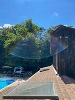
At the time/date of sun transit given by the calculator go to your dish location and see whether the sun is obstructed in any way. If not, then you do not have a line of sight problem.

Unfortunately for your present situation, sun transit does not occur until the first week of October.

To use the calculator:
Select "Anik G1" for the satellite
Enter "Andover, MA" for your location
Select "2022" for the Prediction Year
Select "August to November" for the Prediction Season
Leave the "C/N Mode" "FDS Angle Mode" at whatever its default is
Select "X" or "ku" for the Frequency Band (either will be close enough for what you're doing)
Enter "1" for Antenna diameter
Enter "150" for System Temperature
Click Calculate
A chart will appear in the center of the screen giving the dates/times of sun transit at your location. Go to your dish site at one of the "peak transit" times listed and see if the sun is obstructed at that location. If not, you're good for line of sight.

Sorry sun transit doesn't occur in September, but I got no control over that!
 

Users Who Are Viewing This Thread (Total: 0, Members: 0, Guests: 0)

Who Read This Thread (Total Members: 6)