Satellite Finder Software!

  • WELCOME TO THE NEW SERVER!

    If you are seeing this you are on our new server WELCOME HOME!

    While the new server is online Scott is still working on the backend including the cachine. But the site is usable while the work is being completes!

    Thank you for your patience and again WELCOME HOME!

    CLICK THE X IN THE TOP RIGHT CORNER OF THE BOX TO DISMISS THIS MESSAGE
Status
Please reply by conversation.

stanleyjohn

SatelliteGuys Pro
Original poster
Mar 25, 2010
1,892
30
south/central Ct,USA
I would like to know if anyone knows of a way to have a Pic of your dish showing the location of the satellites in the arc from ground level .This way im sure to know if i will or will not get a sat due to trees,buildings etc.I know they have satellite finder for a few cell phones but my phone is fairly basic and not about to upgrade and pay the extra $$$ just yet.I may try to devise something myself if i cant find any answers here!
 
try www.dishpointer.com . it not only shows you a google earth view of your location with the direction of the satellite but also the height an obstacle would have to have to obstruct the signal. use the green pin for this last feature.
 
Dishpointer.com rocks. Using the satelite photo view, you can see your own house and put the X where you propose to put your dish. The green vector will cross some landmark in the distance to which you can visualy point your dish. You put the red X on the object that you are trying to clear in height and it will tell you if that object will be in the way by telling you how high the vector is at that point. I dug a big hole for my BUD before I discovered Dishpointer only to find I dug in the wrong location. I am glad I did not pour the concrete.
 
try www.dishpointer.com . it not only shows you a google earth view of your location with the direction of the satellite but also the height an obstacle would have to have to obstruct the signal. use the green pin for this last feature.

Thanks!I have been using it but resolution is pretty poor at max zoom and horizontal view from ground level is not much use.I'm thinking of taking some pics at ground level at different elevation angles then plot satellites on the pics so i then have a good idea where a satellite is in relation to the trees,buildings etc in good resolution.Dish pointer would be so much better if i could get a great res pic in a horizontal view vs an above view.I bet such satellite photos are available few the military and a few others :).Heres a example pic!I would be able to tell pretty close where a sat was by looking at a pic.I could get the whole arc by cut and pasting a series of photos together.
 

Attachments

  • 0015a.jpg
    0015a.jpg
    29.9 KB · Views: 214
Last edited:
I think the only way to achieve that sort of geographically individualized photos is by inputting the information from dishpointer into some professional GPS survey equipment and snapping your own photos.Alternately you might achieve results by mounting a lazer (pointed at the sky) onto a motorized dish and taking some time-lapse photos at dusk as the dish swings from one side to the other. The laser may only reflect back on closer objects that it hits. Not sure how it would look in the fog.
 
Somewhere there is an Iphone app that purports to do that.

You point an Iphone camera toward the sky and it superimposes the satellite arc on the screen. You can see where trees and stuff around you lie in relation to the Clarke belt. Also you can see locations of satellites. :)

If it works it should be better than waiting for twice a year at solar outage time. That is just so you can see shadows or look into the sun... :rant::mad: :eek: 
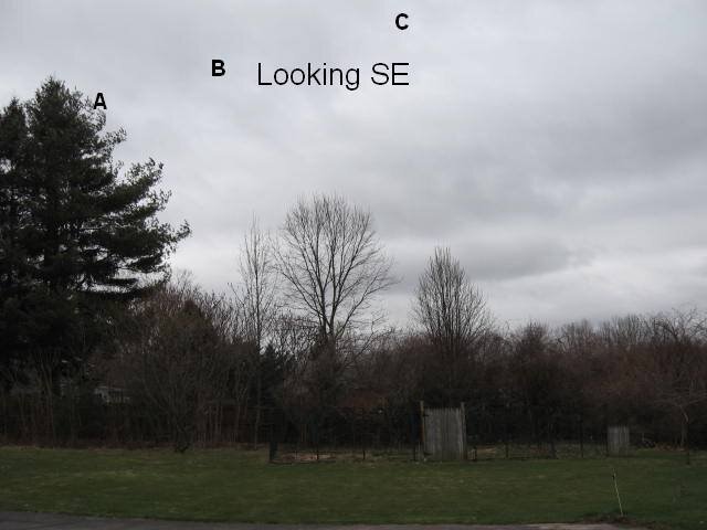
Works good but has limitations...

Can't see why there are not apps for other smartphones, etc that have GPS, cameras and the like....:cool:

I have a modern windows smartphone with that stuff. Sure would like to mess around with software like that....
 
Does the military stand in your back yard at ground level and take photo's ? cause I doubt it lol.

There is a reason google earth photo's are all top down, cause thats the POV of the satellite haha.
 
Does the military stand in your back yard at ground level and take photo's ? cause I doubt it lol.

There is a reason google earth photo's are all top down, cause thats the POV of the satellite haha.

shhh!! Theres a general in the bushes!! Just kidding!!The point i was trying to make is if they can get good enough resolution from above satellite!they would be able to use that with computer software to see what things would look like at ground level!That way you would see what others on the ground would see.
 
Status
Please reply by conversation.

Users Who Are Viewing This Thread (Total: 0, Members: 0, Guests: 0)

Who Read This Thread (Total Members: 1)

Latest posts