I need to go higher. That is the conclusion I came to after sleeping on it. Pretty sure I'm getting reflected signal from the deck and or railing. If that doesn't work I'm removing more trees.

Adventures in Satellite Hunting.....30°W
- Thread starter Inno
- Start date
- Latest activity Latest activity:
- Replies 61
- Views 15K
You are using an out of date browser. It may not display this or other websites correctly.
You should upgrade or use an alternative browser.
You should upgrade or use an alternative browser.
SatelliteGuys Fund Raiser
100%
- Total amount
- $905.00
- Goal
- $350.00
Donation ends:
- Status
- Please reply by conversation.
What size is your dish? How heavy? Can you lift it from the mast and hold it up in the air?
When I first was going after this sat I had a lot of doubts whether some obstacles were in the way or not. I have made several installs in my area and the terrain is very hilly down here. Before I determined the best location for the dish and before I started drilling I would lift the dish up in the air and aiming near where I know it should be I PATIENTLY panned the dish at different heights. My pansat 2500 I use for installs would give a beep then I would decide if to proceed with the install or not.
The high SRs on this sat is very forgiving as you pan so even if you don´t go too slow you should get a beep as you pass by there.
Something extremely important I learned was to be absolutely sure your settings were correct and you had a strong tp selected, like 11883V 27500 or 12050V 27500 or12172H 27500.
Of course the dishes I have set up are 30" and they are light weight.
I´m at 100°W, 26°N. Hispasat is at about 12° over the horizon for me.
Hope this helps.
if you have an iphone or one of your friends has an iphone that you can use then i would suggest getting that application that shows all the satellites in the sky....it will save you alot of time and frustration and will tell you once and for all FOR SURE if the trees are in the way or not.....
I have a friend who installs some Bell dishes and has an I-phone so I showed him the app earlier this week.........I'll have to check with him and see if he got it.
I had a temporary 90 cm offset set up in Fergus Falls, MN at an apartment that I was at.....
several hundred miles south of you, with an elevation of 7.5 degrees.
The trick in making it work was to turn the antenna upside down, so that you reduced the amount of noise pickup from the horizon, as well as clear the bottom of the antenna above the ground.
If you are not using a simple in-line tuning meter, I suggest putting one in the circuit between your receiver and LNBF.
Find a satellite in the center of the arc (95 or 97 West would be good places to start). Twist the LNBF so that it is in the zero skew offset position. Find the calculated elevation angles for various satellites (97, 95, 89, 72, 58, 30). Use your satellite receiver's blind scan feature and turn it on after you encounter a strong signal with the in line meter. Use a set of channel charts such as those found on the www.global-cm.net website. Once you find something, use your angle finder to confirm an elevation setting, and add or subtract angles as you go east towards 30 West. Rotate the LNBF as you move east. Looking at the front of the dish, the 6:00 position should be rotated to about 7:30 (45 degrees clockwise) to get Hispasat.
Rather than lose your mind about determining proper angles for elevation when turning the dish upside down, start by setting the dish for 45 degrees true (halfway between vertical and horizontal). Shift the antenna upwards another ten degrees or so, and pan the center of the arc while listening to the in line meter's beeping sound. You'll find something, and once you do, all should fall in place. I also recommend the Cuban transponder as one of the strongest on the vertical side of 30 West.
Good luck!
PLEASE LOG IN TO GET RID OF THESE ADS!
Thanks Mike. Fergus Falls, about 250 miles south west.........I took my son to hockey school in Detroit Lakes this past summer.
I turned it upside down last night and determined that I needed to raise it up a bit. I welded another 3' of pipe to my mount this evening and tried again. I am pretty well convinced that it is tree related at this point. I am able to lock in 58°W and measuring the elev. from the front of the dish I get about 3°........given that 58°W is at 24.6° elev. at my location I can conclude that my dish offset is 21.6° or for the sake of argument 22° as this seems to be a common offset angle. Therefore 8.5° minus a 22° offset brings me down to -13.5°. So turning the dish upside down will help to reduce noise, I thought it might. I will re-evaluate my tree situation in daylight...........I cut a few more down this evening but did not see any improvement.
I think I am at the point where I have too many thoughts going through my head and I should probably start from scratch so as not to overlook anything.
Well after almost a week of trying I have decided to take a break from the dish until the leaves fall. I have cut down a number of trees (which I had planned to cut anyway) and I now have a signal strength that is a bit higher and on some transponders and the quality meter is jumping up quite a bit higher than I have seen it before. Any other trees that I think might be in the way are ones that we want to keep. I am sure I am pointing at a satellite but I do not know which one. My only safe bet is to wait for the leaves to fall and try again. That way I can be sure it is 30° before I make any other moves.
Funny as I was walking around cutting trees a few days ago I had a song running through my head. It was The Trees by Rush......."There is unrest in the forest, there is trouble with the trees........." lol
Funny as I was walking around cutting trees a few days ago I had a song running through my head. It was The Trees by Rush......."There is unrest in the forest, there is trouble with the trees........." lol
Just looked on the calendar at Sept 23rd. That is the Autumnal Equinox. If you get up at sunrise, and watch the sun come up over your trees that day, you will see the exact spot where the Clarke belt and all the satellites are, including Hispasat. At 8.5 degrees of elevation, you will only have to wait about 20 - 30 minutes to see exactly where it is in relation to your trees.
We'll all look forward to your getting back on this project, and the positive outcome.")
We'll all look forward to your getting back on this project, and the positive outcome.
I don't think there are many satellites near 30W that are visible from this far north. There's one at 37 that I've only been able to pick up one full-time transponder on, and I think it's a data transponder. The nearest other ones are at 15 and 45.
The Clarke belt is actually a few degrees below the celestial equator as seen from the northern hemisphere, since it's "only" 22k miles away. At my latitude, solar conjunction in the fall is about the first week of October.
The Clarke belt is actually a few degrees below the celestial equator as seen from the northern hemisphere, since it's "only" 22k miles away. At my latitude, solar conjunction in the fall is about the first week of October.
PLEASE LOG IN TO GET RID OF THESE ADS!
Just looked on the calendar at Sept 23rd. That is the Autumnal Equinox. If you get up at sunrise, and watch the sun come up over your trees that day, you will see the exact spot where the Clarke belt and all the satellites are, including Hispasat.
This will only be true for those on the equator. For those of us farther north, one needs to wait for the sun to get lower in the sky so it can be "eclipsed" by geostationary satellites. At my latitude of 40N this happens a couple of weeks later, as Jim has already noted. There are sun outage calculators on the internet that will give you exact dates and times for your location.
I looked mine up and I think it falls on or about the 23rd of October here. At that point the leaves should be mostly gone and I will be able to see very clearly where my satellite is!
Edit: It is October 8-13 here between 7:22 and 7:29 for Hispasat 30C as per this site
Sun Outage Calculator
Lets hope those days are sunny!
Edit: It is October 8-13 here between 7:22 and 7:29 for Hispasat 30C as per this site
Sun Outage Calculator
Lets hope those days are sunny!
Last edited:
In the meantime, an unscientific way to determine if you have tree clearance:
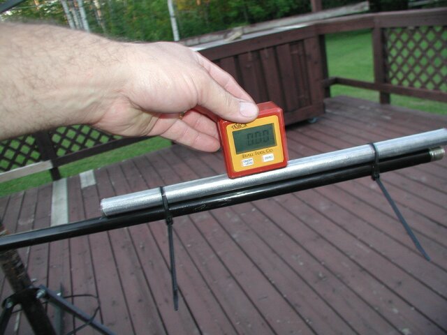
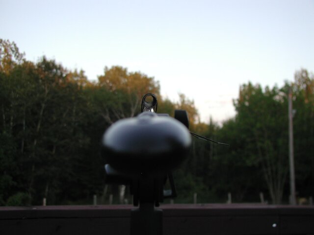
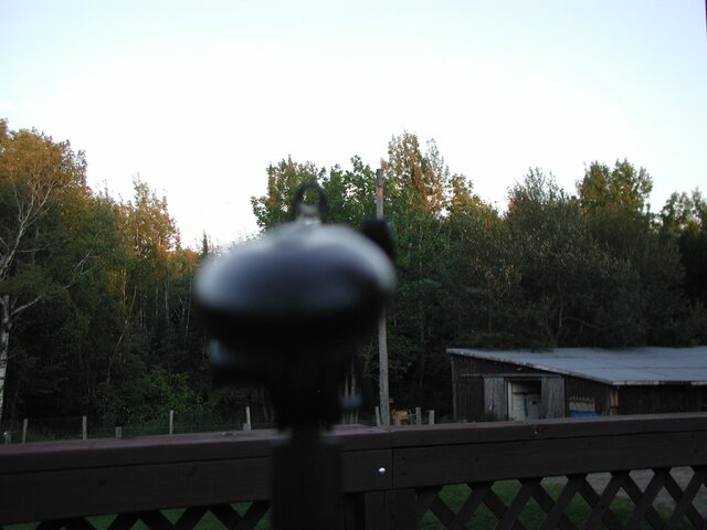
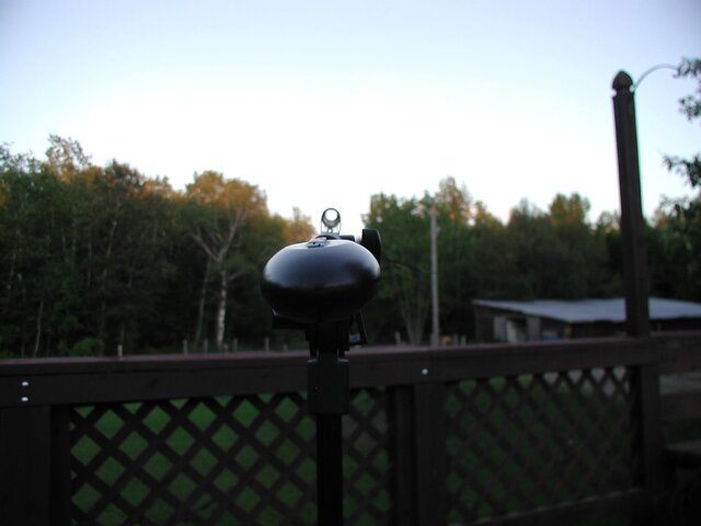
Get a helper to observe, and a short length of pipe, plus an inclinometer (also known as an angle finder).
Use the pipe as you would use the sight on a rifle, and aim in the general direction that your dish is pointing, but perfectly horizontal. Confirm that by reading either 0 or 90 (depends on how the angle finder is placed) and that will be your 0 degree
elevation. If it is 0, raise the pipe so that it reads 8 degrees. If you started at 90 for zero, raise until the angle finder is at 82.
Have your helper confirm these numbers while you look down the center of the pipe. Look off to the side left or right as you blink your eyes and see if there are any trees or other obstructions above the center of the pipe.
My impression by your pictures is that you are probably 2 or 3 degrees ABOVE the tree line and should have no problems.
One other thing; when the dish is turned upside down, you have to do some fast math that accounts for the typical 22 degree elevation TWICE, and the angle above the horizon itself. At due south in Fergus Falls, we are looking at a satellite elevation angle of about 36 degrees above the horizon. This translates to an true elevation angle of almost 60 degrees on the dish.
The quickest way that I found Hispasat was to find 97 West at whatever angle that it was at, drop the dish from 36 degree elevation to 7-8 degree elevation, and pan to the ESE. Remember at due south the LNBF should be pointing to your zero skew reference. For Hispasat, it needs to be rotated clockwise about 45 degrees..to the 7:30 position for the F connector, if you started at 6:00, as viewed from the front of the dish. Similar logic applies to your original P9 comparison, although I am not certain what you might be receiving on the Ku band side of 58 West with a 10750 MHz local oscillator type LNBF. There are signals using a universal (9750, 10600), using the 9750 setting. Make sure that you have a 10750 MHz LO type LNBF in use...which would pick up both Shaw Direct/Star Choice as well as FTA from 97 West. If it works for either, you're OK.
Thanks Mike, I did something similar with a Tilt Box and a 4' level. I didn't think of using a pipe, that would be a bit better way to do it.
I am able to grab 58°W with excellent signal strength and a 10750MHz LO but I can't seem to find anything further East than that. I may try turning the dish upside down but with the mount I have created for it, I think I may have to do some more modifying to get the elevation low enough.
For the time being I have to leave it be as my wife is due sometime in the next week or two and I have to turn my attention to helping her out. I was hoping to find 30°W so that she would have something interesting to watch when the baby comes...........I've not given up I am just taking a but of a break.
Sounds like you guys had some good ideas on the pipe, inclinometer, et al.
Here's my suggestion:
A camera on a tripod, with a digital level on top, then zoom in and look at the center of the picture.
But here are excellent ideas previously posted, which might be useful to the next person who reads this thread.
ThisBUDsForYou and his soda straw inclinometer
http://www.satelliteguys.us/free-ai...a-straw-inclinometer-line-sight-pictures.html
Delta Charlie had some variation on the idea, too
http://www.satelliteguys.us/free-air-fta-discussion/146479-15-min-duct-tape-elevation-gauge.html
PLEASE LOG IN TO GET RID OF THESE ADS!
Just looked at those links Anole. Did someone say a LASER?????? That is a great idea! If I can get one that shoots relatively straight............Just had a few good ideas. When I find some time I will try some things out and post my findings.........and pictures of course.
How about a microphone stand and a piece of conduit?
So IF the satellite happens to be in the clearing I made it's all good.........if it happens to be off to either side then I'm out of luck.
So IF the satellite happens to be in the clearing I made it's all good.........if it happens to be off to either side then I'm out of luck.
Attachments
I think Dee Ann used a laser to see what over-hanging branches might be in her way for some Ku-action.
You need to work at night.
Low power red lasers from the 99¢ store might be okay for the above, and to align your feed/scalar, but wouldn't show on your trees at that distance.
(they're also not co-axial)
Green shows up better to the human eye.
If you really want to go that way, I'm sure we can get you some links for cheap ones.
edit:
But, without knowing the range to your trees, I'd say it's probably too far with any reasonable power (safe) laser.
I do have a machinist friend with some industrial CO² lasers.
He uses 'em to cut pipe.
We could trim your trees from the deck...
Last edited:
Now THAT would be sweet!!! I could change my tune from "The Trees" by Rush to Hank Williams with "Settin' the woods on fire"! Good thing I'm on the fire dept. here.
I have a friend that is a contractor who has a laser transit that supposedly will shoot up to 220', it looses something like 1/8" accuracy at 120' and up (I think).
I have a friend that is a contractor who has a laser transit that supposedly will shoot up to 220', it looses something like 1/8" accuracy at 120' and up (I think).
Well, there's your answer. Get him over.I have a friend that is a contractor who has a laser transit that supposedly will shoot up to 220',
it looses something like 1/8" accuracy at 120' and up (I think).
He can tell you where the cut in the trees is (angle/azimuth) ...
... as well as the height of the trees (the elevation from your deck to the top of 'em).
That's what his equipment is designed to do! - :up
PLEASE LOG IN TO GET RID OF THESE ADS!
- Status
- Please reply by conversation.
Similar threads


- Replies
- 9
- Views
- 1K
- Replies
- 3
- Views
- 723
- Replies
- 6
- Views
- 905
- Replies
- 2
- Views
- 864