alignment issues

Status
Please reply by conversation.

jaray

SatelliteGuys Pro
Original poster
Mar 9, 2010
232
0
Northern Ontario, Canada
I've been struggling for some time thinking that my aiming on my 6' mesh was not quite right.

I am sitting at my true south (89). I set my polar axis elev to 48 (which is my latitude for my area)
At this point I lose signal, then I pull the bottom of the dish inward using the declination bolt and start to see signal come back. I peak using this declination and see descent signal.

This is where the problem starts, when I measure where my dish is facing now that I've supposedly dialed in declination, I am at about 35. So do the math and it equals about 13 declination. My declination is supposed to be 7, not 13. If I change the declination to an angle of 41 (48 minus 7) all signal is gone.

Is there something grossly wrong with my logic here?
 
OK good to know, but I just don't know where to set my declination then. I don't know where to measure this 7 degree's I'm supposed to set. I've been reading until I'm blue in the face and theres just something I'm not getting.
 
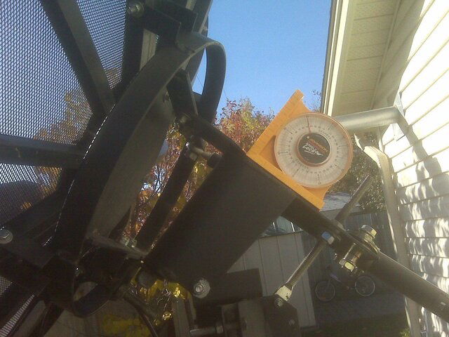
Here is the dish, the spot I have the inclinometer at is where I'm setting the 48 latitude. You can see the declination adjustment at the bottom. Where do I apply this 7 degrees declination?
 

Attachments

  • IMG00161.jpg
    IMG00161.jpg
    342.5 KB · Views: 260
Here is the dish, the spot I have the inclinometer at is where I'm setting the 48 latitude. You can see the declination adjustment at the bottom. Where do I apply this 7 degrees declination?


Declination is the difference between your mount and the actual dish. Elevation is where you have the angle gauge now. to set declination you put the angle gauge on the back plate of the dish. The difference of the two is your declination. So your dish should be 7 degrees lower than where your elevation is.

What I do is measure the angle where your gauge is in the pic. Write that down. Then put the gauge on the back plate of the dish. Write that down. Subtract the two, thats your declination. Adjust it until its 7 degrees lower than your elevation.
 
Last edited:
I'll go thru this again tomorrow, but this is what I have been doing. When I do the math, it tells me I need to set the back plate to 41. I do this, and all signal disappears. I don't have any until I start hitting 35.
The pole is good and plumb. I can't imagine what I could be doing wrong.

I know there are 2 scales on the inclinometer, but I don't think it matter which one I use. As a rule of thumb, I try to keep zero pointing down.
 
I have the same problem setting the Declination, no good place to measure, so I don't.
From your Pic, I looks like you have Way too Much Declination, but that could be the Pic.
Set your Main Axis Elevation just like your Photo, using the adjustment closest to your Angle Finder. Then set the Declination to Peak Signal, that the Adjustment tucked underneath. Your Declination Adjustment looks to be maxed out, so I would start by getting that in the middle. As a guide, stick your Angle Finder to the back of the Dish, on the Center Plate.
Hope that helps.
Then take Stog's advice, one you have this set, and confirm you are tracking the Arc, don't change it. A little advice, since it gets colds where you are, check them Adjustments bolts in the winter, it's amazing what Mother Nature can loosen up.
 
Lak7, I took that pic before I set the declination, so yes it would have been excessive.
When my main elev is set properly, I do find signal after adjusting the declination bolt, but where I do find it, equates to 13 declination when it should be 7. Leaving it like this gets me great signal at my true south 89 and up to 99 but then nothing further west at all, so I make the assumption this is wrong.

It seems everyone has they're own way :-)
Stogie5150's instructions seem like the right way to do this, and its probably carved in stone but it sure leaves me wondering why it doesn't work.
but if everyone has success with it, then there's some anomaly here because it simply doesn't work for me without excessive adjustment.
 
What Degree are you setting your Elevation to?
Are you using the modified Polar Mount angles?
http://www.geo-orbit.org/sizepgs/decchartp.html

I'm thinking that you may need to subtract your Angle Finder reading from 90

From the Modified Polar Mount chart....
Say your Lat is 54 = 7 Declination (6.97)
Main Axis = 90 minus 54.65 = 35.35 reading on the Angle Finder
 
Last edited:
I'm setting the elev to 48, the latitude for my area. I was told to just subtract 7 from that and set the declination to that value, which in my case would be 41.
 
I am using the modified chart at that url, yes. I am at 48 and am using 6.42 for declination. I had been using 7 based on the other chart but either or would get me in the ballpark.
So are you telling me to set my main elevation to 42 (90 minus 48 =42) then measure the rear ring to be 6.42 less than 42 for declination?


What Degree are you setting your Elevation to?
Are you using the modified Polar Mount angles?
Footprints by Dish Size - Latitude Declination Chart - C/Ku-Band Satellite Listing

I'm thinking that you may need to subtract your Angle Finder reading from 90

From the Modified Polar Mount chart....
Say your Lat is 54 = 7 Declination (6.97)
Main Axis = 90 minus 54.65 = 35.35 reading on the Angle Finder
 
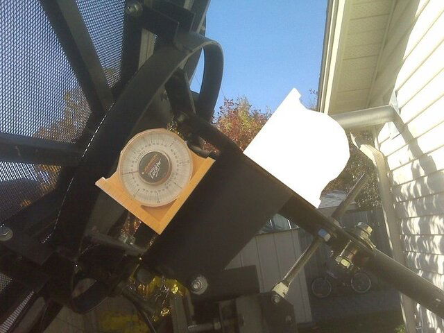
Will the Angle finder fit like this, see pic?
Is that part Square to the Main Axis pivot point?
I think then you would not have to subtract from 90
 

Attachments

  • likethis.jpg
    likethis.jpg
    75.3 KB · Views: 183
hehe, I think most of my problem is I take instructions for EXACTLY how they are written. If there are differences in peoples instructions (or variables) then this leaves room for errors and people start making assumptions of what is right, people...meaning me hehe.
 
Good call...it doesn't fit perfectly but I used a 2x6 to extend it and measured the same 48 there as I did on the top, so I'm continuing to use the top. For all I know I'm using the inclinometer the wrong way! But I doubt it, as I always keep the magnetic side against the surface being measured.


Will the Angle finder fit like this, see pic?
Is that part Square to the Main Axis pivot point?
I think then you would not have to subtract from 90
 
I have seen this video, and I just watched it again. It does make more sense to me this time, but I am already doing what it told me.

Here is the details...it would be nice if someone could confirm these numbers too:

my elev=48, so I set 48.65 for elevation on the main axis (Thunder Bay, ON Canada)
declination is to be 6.48.
So I added the 48.65 to 6.48 for a total of 55.13 declination to set on the dish face or back across the ring.

I went out set the angles, and quickly find out that I could never get a 55 degree angle from the declination adjustment...it just doesn't go that far.

So now, I am at a loss. Instructions tell me to add add the Declination Offset Angle (6.48) to the Elevation Angle (48.65) to get my total declination angle that I need to set on the ring at the back of the dish. Is this wrong? Every set of instructions tells me to do this...

Each reading is taken with the inclinometer "0" facing down
 
Last edited:
You must be measuring something wrong. Using the wrong reference, or intermixing references. Take a quick gander at the BUD Manual I put together. It's may just hold the answer. Let us know how it goes.
 
I've had a good look at the bud manual. I now completely understand where to set the angles and what numbers to use, but put into practical use something still is wrong.
I guess I'm just hoping someone could look at my numbers I posted and confirm that they're right and that I'm applying them in the right places. I need to be sure of that before I can start looking for problems elsewhere.
 
Status
Please reply by conversation.

Users Who Are Viewing This Thread (Total: 0, Members: 0, Guests: 0)

Who Read This Thread (Total Members: 1)

Top