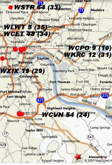
Your map is really helpful. Can you tell me what channels the dots are? Also I am not too savvy on the local HD channel numbers, as well as the call letters and what they are. I know on analog my guide says: 5=WLWT (NBC), 9=WCPO (ABC), 12=WKRC (CBS), 19=WXIX (FOX), 14=WPTO (PBS??), 48=WCET (PBS) 54=WCVN (PBS) 64=WSTR (PBS???), 84=HSN.
On your map, my house would be right about on the "Q" in MapQuest at the far bottom right corner of the map. The the true north indicated on my pic is pretty darn close to true north. I pulled out the ole' compass and did the hold-it-up-to-your-eye-and-look-at-landmarks-where-the-guide-wire-points trick. According to your map, it looks like I will be needing to point antenna more towards NNW. I will try to figure out the angle from the "Q" on your map to the dots. (Need to remember my old geometry schooling from high school...print out map draw line from Q to dots, which would make a right triangle with the edges of image...measure the lines...and 3-4-5 thing???...google will set me straight) Just from eyballing it, it looks closer to 45 degrees left of due north, which would put it closer to the tall tree on the far left of my panoramic shot.
On your map, my house would be right about on the "Q" in MapQuest at the far bottom right corner of the map. The the true north indicated on my pic is pretty darn close to true north. I pulled out the ole' compass and did the hold-it-up-to-your-eye-and-look-at-landmarks-where-the-guide-wire-points trick. According to your map, it looks like I will be needing to point antenna more towards NNW. I will try to figure out the angle from the "Q" on your map to the dots. (Need to remember my old geometry schooling from high school...print out map draw line from Q to dots, which would make a right triangle with the edges of image...measure the lines...and 3-4-5 thing???...google will set me straight) Just from eyballing it, it looks closer to 45 degrees left of due north, which would put it closer to the tall tree on the far left of my panoramic shot.