Dish Satellite finder app advice?

Timbee

Active SatelliteGuys Member
Original poster
Oct 25, 2018
24
12
Northeast USA
Looking for a satellite finder app for my Android devices that I can use to position our Winegard Pathway X2.

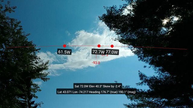
As I understand it there's a western and eastern arc each consisting of 3 satellites? The few apps I've looked at so far seem overly complex-- at least for this beginner. Is there a "Dish-specific" app that only shows the positions of Dish satellites?

Also, if there's 3 different satellites, how does one pick between them in order to position the Pathway? To this point I've basically used trial and error. Point it southward and let it do it's thing. Last place we were at there were many trees and it took multiple tries to find an opening where I could get a signal. Hopefully using an app would make things easier.
 
Aren't those automatic in finding the sats by itself? If so, slap it down on a level surface with clear view of the South, connect it up, and turn on your receiver.

If the first spot doesn't work well, move it a bit until you get signal. The higher off the ground it is, the more likely it'll clear trees and such.

DishPointer - Align your satellite dish

If it was only that easy! :) We're traveling in an RV and for those sites we're at with a clear view to the south-- it's a no brainer. Turn it on, scan and let it do its thing.

But for sites like where we're at now it ain't that easy. We're surrounded by tall trees with a steep drop off to a river on one side. There's a few relatively narrow openings in the tree canopy and not knowing exactly where the sats are I had to use trial and error and try several different positions-- and wait 15 minutes or so to find out if it got a signal. If I had a better idea of the location of the sats I think that would increase my chances of finding the right spot.
 
If you bring up Google Maps on top of a likely place in the campgound, you can click on the little box in the lower left and change to satellite mode. Zoom down to the spot on your campsite lot where you want to put the dish. RIGHT-click that exact spot on the lawn.

A menu will pop up, click on "What's Here?" and you will see the exact lat. & long. map coordinates of that exact spot! Copy/paste those into the Dishpointer "Your Location" box. In the Dishpointer "All Satellites" box, select the various sats you plan on wanting to see (Echostar). Hit the SEARCH button, and it'll bring up your site map and a green arrow pointing to that exact satellite. You can zoom in or out, and if need be, move the pointer on the campsite to find the best spot before placing the dish.

DishPointer - Align your satellite dish

Or he can just open the Winegard app on his phone, tap a couple of buttons and actually see on the screen where the sats are located in relation to any trees, etc., from the potential dish location. The DishPointer web site can't show you that. DishPointer does have a paid app with a similar virtual reality feature to the Winegard app though. Below is a screen capture from that app.
 

Attachments

  • FoP8bvNl.jpg
    FoP8bvNl.jpg
    47.6 KB · Views: 330
If you bring up Google Maps on top of a likely place in the campgound, you can click on the little box in the lower left and change to satellite mode. Zoom down to the spot on your campsite lot where you want to put the dish. RIGHT-click that exact spot on the lawn.

A menu will pop up, click on "What's Here?" and you will see the exact lat. & long. map coordinates of that exact spot! Copy/paste those into the Dishpointer "Your Location" box. In the Dishpointer "All Satellites" box, select the various sats you plan on wanting to see (Echostar). Hit the SEARCH button, and it'll bring up your site map and a green arrow pointing to that exact satellite. You can zoom in or out, and if need be, move the pointer on the campsite to find the best spot before placing the dish.

DishPointer - Align your satellite dish

That's an interesting and creative option. I'm quite familiar with Google Maps features but never considered using it that way.
 
Or he can just open the Winegard app on his phone, tap a couple of buttons and actually see on the screen where the sats are located in relation to any trees, etc., from the potential dish location. The DishPointer web site can't show you that. DishPointer does have a paid app with a similar virtual reality feature to the Winegard app though. Below is a screen capture from that app.

I think I did look at the Windgard app earlier but as it had relatively poor ratings, didn't follow through. Just downloaded it now and I have to say from what I see it looks like just what I need. I'll give it a try tomorrow during the day to see how accurate it is. Our current location will be a good test!
 
  • Like
Reactions: NYDutch
I think I did look at the Windgard app earlier but as it had relatively poor ratings, didn't follow through. Just downloaded it now and I have to say from what I see it looks like just what I need. I'll give it a try tomorrow during the day to see how accurate it is. Our current location will be a good test!

I've compared the free Winegard app to the $20 DishPointer app, and I've found the accuracy to be just as good. For my last 10-12 tripod 1000.4 dish setups, I've only used the Winegard app to find the best dish locations.
 
  • Like
Reactions: JSheridan
I've compared the free Winegard app to the $20 DishPointer app, and I've found the accuracy to be just as good. For my last 10-12 tripod 1000.4 dish setups, I've only used the Winegard app to find the best dish locations.

Are the satellites labelled to tell the difference between a Dish and a Directv satellite? Also is internet required for this to work?
 
The Winegard link I posted shows the options. After you open the app and select "Satellite Pointer", you next choose between Bell, DTV, Dish, and Shaw. The satellites for that service are then listed, and tapping the "View AR" button brings up the overlay of those sats on the live camera view when your facing in the right direction. Arrows will guide you toward the correct direction. No Internet is needed to use the app, just to install it. It's a free app, give it a try...

Capture+_2019-03-19-08-21-36.png
Capture+_2019-03-19-08-21-54.png
 
  • Like
Reactions: charlesrshell
The reason I asked about wifi/internet/4G is my phone is 4G, but my tablet will only work on wifi. The tablet of course is bigger, so I would prefer to use it.
As long as your tablet has GPS and compass functions, it'll work ok. My phone has a 5.7" screen, and that's plenty big enough for me.
 
Last edited:
  • Like
Reactions: primestar31
I've compared the free Winegard app to the $20 DishPointer app, and I've found the accuracy to be just as good. For my last 10-12 tripod 1000.4 dish setups, I've only used the Winegard app to find the best dish locations.

By way of update... we moved to a new site today and were presented with a similar challenge in finding Dish Satellites. Opened the Winegard app you recommended where I could see that the Western arc of the Dish sats-- which was what I wanted since that's where the local network channels were-- were right along the tops of tall trees to the South with very few openings. Even at the far edge of our site there were issues. My neighbor across the road kindly gave me permission to set up at the outside of his site (fortunately I have lots of coax) where the app showed I would just clear the trees.

Fired up the Wally and after the usual "Complete Signal Loss" message (?) it continued on through the acquiring and downloading Guide routines and-- Presto. Everything-- including the networks--came in!

Not that it would have been impossible without the app, but it made the preliminary scouting much more efficient. Many thanks for the input!

On a related front, if I recall correctly, Dish info states to use a maximum of 50 feet of coax. However in a few situations I've had to use around double that. Perhaps Dish is just being intentionally conservative?
 
I'm glad it worked well for you! I agree, the app is a big time saver when setting up.

As long as you're using good quality RG6 coax, I suspect it will work ok. The signal levels might be a bit lower though. I'm sure Winegard is being conservative with the 50' max to avoid a lot of tech support calls when poor quality extensions are used.
 
  • Like
Reactions: charlesrshell

Users Who Are Viewing This Thread (Total: 0, Members: 0, Guests: 0)

Who Read This Thread (Total Members: 1)

Latest posts