Lyngsat Lite

  • WELCOME TO THE NEW SERVER!

    If you are seeing this you are on our new server WELCOME HOME!

    While the new server is online Scott is still working on the backend including the cachine. But the site is usable while the work is being completes!

    Thank you for your patience and again WELCOME HOME!

    CLICK THE X IN THE TOP RIGHT CORNER OF THE BOX TO DISMISS THIS MESSAGE
Status
Please reply by conversation.

kymics

SatelliteGuys Pro
Original poster
Jun 16, 2006
208
0
Winnipeg, Manitoba
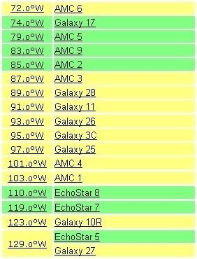
I got this cool program SnagIt installed on my work PC today, so I was putting it through its paces. I decided to created my personal view of Lyngsat's chart for what's really available to me as a Ku user here in Southern Manitoba.. talk about shrinkage :p
 

Attachments

  • Lyngsat Ku FTA List.jpg
    Lyngsat Ku FTA List.jpg
    26.3 KB · Views: 280
Just curious, what's the difference between using that software and just hitting alt / print screen on the keyboard and pasting it in any photo editing software?
 
That's the way I used to do my captures. SnagIt lets you grab it and edit all at once. It also has a scrolling capture so if the screenshot is too big it will scroll and capture the whole page. From there you can just drag to trim the capture to the right size.

As you can see with this particular capture, these coordinates don't all show up together on the Lyngsat screen, so I grabbed and moved them to line up sequentially. Real easy.
 
Status
Please reply by conversation.

Users Who Are Viewing This Thread (Total: 0, Members: 0, Guests: 0)

Who Read This Thread (Total Members: 1)