My New FTA System is on the Way...Questions about SG2100 Alignment & USALS

Status
Please reply by conversation.
Good question and I think it might be a bug. My Pansat 1500 will do the same thing. When I scan SBS6, I have 3 channels logged in there normally
-Ohio News Network (labeled ONN)
-ABC New Orleans
-WB New Orleans
The NO stations are labeled by call sign. When I do a blind scan, the NO stations will sometimes show what I have labeled and sometimes show “TV3 & TV4” and thus creates duplicates.

G10 is worse. I have all the channels labeled call sign, channel, network and when I blind scan, it always scans a 2nd batch with just call sign. But if I don’t change the name it doesn’t do that….weird
 
Well, changing the subject to my SG-2100 motor (which was my original topic for this thread anyway!), I just finished installing the motor on my mast and my dish (Winegard 76cm) on the motor. I set the motor elevation equal to my latitude of 40 degrees and the dish elevation to 24 degrees (30 minus my declination angle of 6.3 equals 23.7 which I rounded up to 24). While everything seemed to go together just fine, I'm concerned that my true south elevation is a little low. When I had the dish mounted on the mast without a motor and I measured the angle of the LNBF arm with my Johnson angle locator, the measurement was about 44 - 45 degrees, which matched up exactly with the true south elevation of 44 degrees which I had set using the scale on the dish. However, after setting the motor and dish angles and mouting the dish on the motor, the angle I'm measuring on the LNBF arm is now about 33-34 degrees...about 10 degrees less than what it was for true south with the dish mounted directly to the mast. I could be wrong, but it seems that the true south elevation of the dish should be the same regardless of whether the dish is fixed or mounted on a motor, so I'm trying to figure out what I've done wrong. I did verify that my mast was plumb and that the motor arm was set at zero prior to starting the installation. The only thing I can think of right now is that I may have set the elevation incorrectly on the motor. I used the little pointer triangle molded on the side of the motor to set my elevation angle, but unless I was supposed to use another marking or reference point to set the angle on the motor, I'm stumped at the moment.

EDIT:
I had another look at the motor mount and realized that there are two completely different scales--an "Elevation" scale on one side of the mount and a "Latitude" scale on the other side. I had originally used the elevation scale to set my latitude, but after noticing the latitude scale on the other side of the mount, I set my latitude on the latitude scale and the dish elevation now appears to be correct for true south.
 
Last edited:
IA6Newspath said:
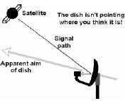
I'm concerned that my true south elevation is a little low. the angle I'm measuring on the LNBF arm is now about 33-34 degrees...about 10 degrees less than what it was for true south with the dish mounted directly to the mast. I could be wrong, but it seems that the true south elevation of the dish should be the same regardless of whether the dish is fixed or mounted on a motor, so I'm trying to figure out what I've done wrong.

You did nothing wrong.

I had the same reasoning about the angle of LNBF arm and failed when I did my setup , the dish is offset so the angle on the arm will not show the correct inclination ,the fact that you are off about 10 degrees or more sounds about right because the signal is coming in from a higher angle, PSB has illustrated this in another thread which I can't find now , hopefully he or someone else can guide you better.

I think you're getting closer to success, good luck, wish I could be of better help, I've been setup for close to 4 months and my memory is failing me, it took me several days and many tries to get it right.
 

Attachments

  • dish angle.jpg
    dish angle.jpg
    4.3 KB · Views: 106
Last edited:
IA6Newspath said:
I had another look at the motor mount and realized that there are two completely different scales--an "Elevation" scale on one side of the mount and a "Latitude" scale on the other side. I had originally used the elevation scale to set my latitude, but after noticing the latitude scale on the other side of the mount, I set my latitude on the latitude scale and the dish elevation now appears to be correct for true south.
This would make a good "Tip from the Iceberg" tip, as that scale on the SG-2100 bracket lends itself to being misunderstood :)
 
I had better luck using the "elevation" side with the elevation chart in the book.
 
Status
Please reply by conversation.

Users Who Are Viewing This Thread (Total: 0, Members: 0, Guests: 0)

Who Read This Thread (Total Members: 1)