Hey everyone I have good reception on the 61w, 63w, 72w, 79w, 89w, and 125w satellites. I have intermittent reception on 101w and weak reception on 83w and 97w. I have a row of pine trees in my yard from like 72w-119w and was wondering if there is some kind of laser pointer lnb available that I can point at the trees to figure out what trees or branches are in the way. I am thinking I may only have to cut a few branches.
Satellite aiming laser pointer LNB
- Thread starter rrob311
- Start date
- Latest activity Latest activity:
- Replies 21
- Views 13K
You are using an out of date browser. It may not display this or other websites correctly.
You should upgrade or use an alternative browser.
You should upgrade or use an alternative browser.
- Status
- Please reply by conversation.
rrob311,
You should have been using the solar outage calculator last week. You can still get some useful information out of it, it isn't too late! It won't be perfectly accurate, but it will assist you. No laser pointer required, just track the sun.
Sun Outage Calculator
RADAR
You should have been using the solar outage calculator last week. You can still get some useful information out of it, it isn't too late! It won't be perfectly accurate, but it will assist you. No laser pointer required, just track the sun.
Sun Outage Calculator
RADAR
Well not a laser, but with a compass and a straw you can find out if the trees are in the way or not. Check this old thread for details....
http://www.satelliteguys.us/free-air-fta-discussion/122722-$0-soda-straw-inclinometer-line-sight.html
http://www.satelliteguys.us/free-air-fta-discussion/122722-$0-soda-straw-inclinometer-line-sight.html
I seem to recall member Dee_Ann using a laser pointer at night, to check her trees.
Don't remember the exact details, though.
I'd think if you got a one-dollar laser at the 99¢ store, and mounted it to a small block of wood/plastic/foam, you could attach it to the dish.
Then, at night, set the dish to True South.
If you blew some smoke through the beam you could use an inclinometer to adjust it to the correct elevation.
(those lasers are not concentric, so make sure it's not aimed off to the east or west)
Then, sweep your dish through the arc, and see what tree lights up.
Worst case, you might get a brighter laser, or even a cheap green one (easier to see)
However, the ideas above do seem better.
Especially the straw trick.
Maybe mount it on a camera tripod for ease of use.
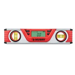
I use a digital level, $39 at Home Depot, just sight up the top edge of it and point it at the tree line, then press the "hold" button to allow you to read the display. I later added an old gun sight to the top of the level, but it worked ok plain. This level has magnets on the bottom side, great for leveling your posts. When you are done with FTA you can use it around the house.


Last edited:
i highly suggest if you decide to aim a laser into the sky, you dont want to aim it near an aircraft. here in LA, someone was recently arrested for hitting a laser at a plane. how they found the person, i'll never know.
You could try Dishpointer.com Its satellite shot might be close enough to tell you which tree. Then it can tell you the elevation of that signal at that tree. Measure up the tree with a measureing tape or survey tool and chop away.
dishpointer has an excellent iphone app as well.
Yes they do. I was lucky the google maps of my area are extremely detailed and I can very clearly see each individual dish in my yard so it was a snap to use their web app to figure things out. There is also an obstruction option on the site that helps you figure out if trees are in the way but you have to be really good at guessing the height of the trees. One thing that helped, my dad told me that on a regular telephone pole with power lines, the bottom lines are cable TV and telephone wires. The real electric wires that power your house, they are by law, required to be no lower than 16 feet from the ground So look above the bottom wires (phone and cable) for the next wire up, that's power and it will be 16 feet from the ground. Use that to help you guess the height of the trees near by.
The iPhone app though, I had trouble with it, I guess I'm not understanding how it works, it was difficult for me to use and understand. Maybe if I mounted my iphone on a tripod to hold it steady it would help. But it's probably I just wasn't doing it right. So I just used their web app standing in the back yard to show me where to aim and all that. Way easier.
I am pretty sure I have a tree blocking 97w partially because I hardly get anything on it. I just need an easy way to figure out which tree it is. I have an offset dish. The trees are probably 90 feet or so from the dish.
Motor your dish over to 97W and get behind the dish and sight up the LNBF support arm. This will tell you what tree is in the way. To find out what limbs are in the way, look up the elevation of the satellite for your location and use an inclinometer or cut out the poor man's inclinometer that is on the last page of the GEOSATpro DSR200c / DVR1100c Owners Manual.
dishpointer has an excellent iphone app as well.
I've got that app. In fact, that was the first app I ever bought. I freak out friends with it. I just tell em yup, that sat is there, and there's that one, and that one and.... They just sit there in awe.
I've got that app. In fact, that was the first app I ever bought. I freak out friends with it. I just tell em yup, that sat is there, and there's that one, and that one and.... They just sit there in awe.
How much is it for android? If it is as accurate as people say I think that may be my ticket.
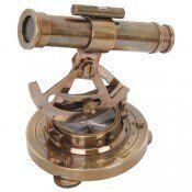
I use old world technology from Harbor Freight and it was under $20 with coupon. Set it on a tripod and check out the LOS!
View attachment 62880
what is it called?
what is it called?
alidade
I always called it an old fashioned transit thinga-ma-jigg!
This is one of a few items at Harbor not from China! :shocked
It is made of brass in India.
thats funny I just ordered a Hoppy split image transit for measuring floor slope. I will look into that.
That's a pretty cheap price for your alidade, so I looked it up on the Harbor web site.
After reading such descriptions as:
- reproduction
- for decorative use only
I wasn't sure if you were serious or just making a good joke.
But, since it's got a 30-day refund policy, I guess ya just can't go wrong!
Should we have a review, and instructions on using one?
Wouldn't be the most expensive tool any of us have.
It does work! :up
They have to make those statements to protect themselves. It is not intended for use in legal trade in
other words.
It is probably better than the ones that brought our forefathers over from Europe! :
:
They have to make those statements to protect themselves. It is not intended for use in legal trade in
other words.
It is probably better than the ones that brought our forefathers over from Europe!
 :
:
Last edited:
I wasn't sure if you were serious or just making a good joke.
Now you sound like my wife!!!...
Last edited:
- Status
- Please reply by conversation.
Similar threads
- Replies
- 8
- Views
- 253
- Replies
- 3
- Views
- 148
- Replies
- 9
- Views
- 203
- Replies
- 7
- Views
- 920


