C band set up - cannot lock on any birds

  • WELCOME TO THE NEW SERVER!

    If you are seeing this you are on our new server WELCOME HOME!

    While the new server is online Scott is still working on the backend including the cachine. But the site is usable while the work is being completes!

    Thank you for your patience and again WELCOME HOME!

    CLICK THE X IN THE TOP RIGHT CORNER OF THE BOX TO DISMISS THIS MESSAGE
Status
Please reply by conversation.
Well I have tried all of your suggestions - still no luck. I get 45% signal intensity and 10% signal quality consistently.

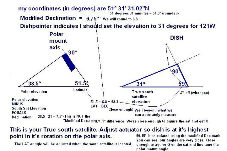
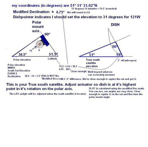
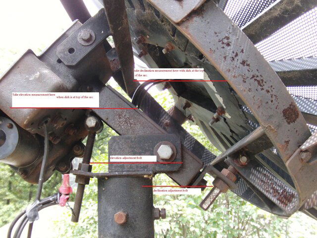
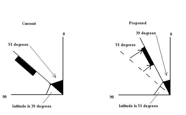
1. Elevation/declination: I have a magetic protractor to verify elevation and declination - both are correct. I verified that the polar mount is at 51 degrees and the declination adds another 7 degrees.
2. I have measured from 3 points on the dish to the scaler ring to ensure it is centered.
3. I have adjusted focal lenth to 44 inches and f/d to 36
4. I adjusted the dish to true south and then moved the base to try and get 121W
5. Pole is plumb
6. Dish is not warped (but might be soon if I can't get this to work!)

I am very frustrated that I cannot get any improvement. I installed the new DMX741 and connected the satellite finder - no change at all. The only guesswork if finding the sat's and I have painstakingly moved cm by cm from true south to try and get 121W or 123W. Is it my dish? Is it the openbox S9? I am going through antenna setup on the S9 to see the tp intensity and quality - is this correct? Any other suggestions?
 
I verified that the polar mount is at 51 degrees>> but is it the "Proper" 51°? Might be 90 off.(39°) Try that once. If you still can't get it, the best thing to do is try adjusting the elevation, in steps, and panning the sky at each step with the mount.
 
Here is what I have: StarTrak 10’ dish, StarTrak c band lnb,
Superjack actuator, GI350I receiver


What I would do if you think you are on with the dish is hook that GI receiver up and look for an analog channel..... G-5 (is how that receiver should display it,) has one analog feed on TP 3... AMC10 also has analog channels... (QVC, HSN ) . Try to locate those. If you find them then check out how your MPEG receiver is hooked up and try again. Find a signal with the analog reciever, then splice in the other receiver. At least that would be another way to check the dish out..... Have a great day!
I should add... G-16, (G-4 on the GI) has a analog tp on ch 16 along with ch 17 on the same bird...
 
One other thing to think of is lnb skew. i fought an old starchoice dish last weekend for 2 hours only to find the lnb was 90 degrees off. ie. vertical was horizontal and vice versa. had it peaked 5 minutes later. arggh.

crackt out,.
 
you said the declination adds another 7 degrees? Is it suppose to add or substract? I am under the impression the declination setting forces the dish to loook downward 7 degrees more to match the SAT signal elevation. Just a thought? Can you meassure your Dish elevation? (some use a flat board accross the dish face) and check it equals your true south sat elevation?.
 
I adjusted the polar mount elevation to 39 degrees per FaT Air - no difference so I set it back to 51 degrees. I put a 2x6 board across the dish at true south and put the protractor against the flat side facing the middle of the dish (which is flush to the dish edges) - it reads 59 degrees which I believe is correct as the charts indicate 121W is at sat elevation of 31 degrees or am I off my rocker here? I tried with just using the GI on G4, G5 - no signal. I noticed a C band set up about 20 minutes down the road - I'm going to drop by tomorrow to see if I can get some pointers/assistance.
 
It sounds like you did things basically right.

I can't think of anything else.

To understand the declination angle, you have to visualize the satellites orbiting on the plane of the equator. If you were located on the equator, there would be no declination necessary, because the satellites would be in a straight line in the sky. the dish points straight up and exactly east and west.

The farther north or south you go, you start to see the curve of the Clarke Belt orbit. The declination angle makes the dish aim at the particular arc or orbital curve in the sky at your particular latitude. It's just geometry
 
To put it in the easiest terms possible, Elevation will grab the birds at the center of the arc... Declination deals with the ends of the arc.
 
Better yet....... See if the following can explain better...

Declination angle keeps satellite antenna from aiming into deep space and changes value with latitude in accordance to earth's curvature. Early astronomers developed the polar mount to track stars. For deep space tracking, i.e. star observation,the elevation setting of the polar mount is equal to the latitude of the site location. However, geostationary satellites are much closer to earth than are celestrial objects and their observation requires a slight tilting 'downwards' from deep space observation settings to see the geostationary satellite arc. This adjustment of the polar mount, the tilting downwards, is the declination adjustment of the polar mount and its amount is the declination offset angle (not to be confused with the declination angle which is the sum of the declination offset angle and the polar axis zenith elevation angle).
In summary, the declination angle lowers the satellite antenna from looking into deep space to look at the arc of geostationary satellites. However, upon practice, it has been discovered that using the latitude as the elevation angle, the satellites at the top of the arc, in a tracking mount system, were in perfect alignment with the satellite dish, i.e. were tracked perfectly by the polar mount, whereas the satellites at the lower ends of the arc where not tracking correctly. Conversely, if the satellites at the ends of the arc, on the horizon, were tracking correctly then the central satellites, at the top of the arc would be slightly off target. This effect is caused by the slight deviation from the true north/south line, caused by the act of the tilting of the dish, as the dish moves to view satellites lower on the arc, i.e. closer to the horizon. With this in mind, it was formulated the elevation/declination angles of the modified polar mount whose application has no effect on seeing satellites at the top of the arc but has the effect of better tracking on the sides and low end of the arc. This effect is accomplished by slightly increasing the elevation angle and accordingly slightly decreasing the declination angle by the same amount. Elevation and declination angles are always measured and applied when the dish is at its zenith, i.e. highest point in the arc, when the dish axis is aligned along the true north-south line.


Elevation Angle is the angle measured on (at) the pivot axis of the mount. To get the Total Declination Angle setting as measured on (at) the back of the dish ring (dish mount), add the Declination Offset Angle to the Elevation
Angle.

The difference between the Total Declination Angle and the
Elevation Angle is the Declination Offset Angle.

Elevation and Declination Angles are always measured and applied when the dish is at its zenith, i.e. highest point in the arc, when the dish axis is aligned along the true north-south line.
 
I think of it like this- imagine the Clarke Belt was a big round line in the sky. If you were to be situated a hundred thousand miles above the north pole, on the Earth's axis line, and looking down at the Earth and the Clarke Belt, that Clarke Belt orbit would look exactly circular. If you were to drop down toward the equator, you can't go through the Earth, so you would have to pass through the plane of this circular orbit somewhere off center.

As you approach the plane of the equator, the look of the curve changes. Think of a hula hoop as representing the Clarke belt orbit. As you stick your head through the hoop, the higher your head goes, the curve of the hula hoop looks rounder. That change in look is what declination is for. It allows the dish to point at the curve
 
One other thing to think of is lnb skew. i fought an old starchoice dish last weekend for 2 hours only to find the lnb was 90 degrees off. ie. vertical was horizontal and vice versa. had it peaked 5 minutes later. arggh.

crackt out,.

I had this same problem with my first "modern" C-band LNBF. I had to rotate it 90 degrees from the markings so vertical in the receiver setup was vertical, and horizontal was horizontal.

I knew my dish was aimed correctly, since my $5 surplus store Chaparral servo-motor polarity control LNB got plenty of signal, but only on one polarity at a time since my digital receiver could not switch it.

Try twisting the LNBF 90 degrees, a quarter of a turn, in the holder and re-look for signal.
 
Is the throat of the feed clean? Could be an old wasp nest in it. Is the servo operating, changing polarity by moving the probe in the feed? Remove the LNB and check for corrosion in the wave guide.
 
I installed a brand new DMX741 so no wasp nests in the lnb. I am back at home (dish is at my cabin) but will return in 2 weeks to spend the week trying to get my "hobby" working ;). I'll continue the thread if I am still having struggles - I think I will start from scratch and re-check everything again. I have a new openbox S9, new DMX741 - if I still can't get anything maybe I need a new dish :mad: - I won't go there yet...this hobby is getting expensive :eek:

Thanks to all for your helpful comments/suggestions...I'll keep trying!
 
Looks like your doing things correctly! something is not right though since your still not getting any good sig and Q. Next time you head to the cabin please take along a digital camera or a cell phone with a camera and take a few pics.A pic is worth a thousand words and we might see something incorrect in a pic.PS! the 741 can be a pain in the butt to set up! I know first hand but when it is set-up correctly it will do a nice job.Hope your not using that dielectric plate that came with the 741! this is for circular satellites only.
 
Last edited:
For starters, it sounds like the dish elevation angle is set WAY to high for your location and you are shooting far, far , far above the satellites!

  • For your location, the face of your dish needs to be set at approximately 31 degrees at the apex (top) of the arc with the dish centered on its mount. This angle is the result of using the modified polar mount setting and the declination of 6.70 degrees. When the dish is perfectly centered on the mount, use a straight edge placed on the rim of the dish on the vertical axis. Make sure the dish face elevation angle is set at approximately 31 degrees.
  • Set the LNBF vertical marker at Zero (0) / 12 noon position. (this may actually need to be set at the 3 o'clock position as noted in other posts.
  • The satellite that is directly south of your location is 121W (Galaxy 23). This satellite is less than 3/10ths of a degree west of your location, so it is an excellent satellite to start aligning on. Do not try to receive any other satellite until you locate this satellite.
  • Rotate the dish mount on the pole until the dish is aimed at compass reading 131. Make note of a landmark like a telephone pole or tree that is as far away as possible (on the horizon or a mile or so away) that lines up with this compass reading.
  • On the receiver select satellite Galaxy 23 @ 121W. Set the LNBF to Single/Standard type with LO of 5150. Select or input transponder Frequency - 3900, Polarity - Vertical, Symbol Rate - 27684.
  • With a small TV next to the dish, SLOWLY rotate the dish left and then right of the landmark that was identified with the compass reading of 131 degrees. SLOWLY pan the dish 10 or 15 degrees on either side of the landmark. If you do not observe the Signal Quality meter reading increase, increase or decrease the elevation angle by one degree and sweep this area again.
  • If you are unable to get a Signal Quality reading, rotate the LNBF 90 degrees and repeat this process.
  • Once you have Signal Quality reading, scan the satellite to verify that you are on Galaxy 23. You should see the RRSat Mux with Al Jazeera and 8 other channels on this transponder frequency.
Good Luck!
 
Think I'll just post a picture as SatelliteAV has covered what I had typed. Think the diagram will help you "See" the angles.
 

Attachments

  • BuckmasterBC.jpg
    BuckmasterBC.jpg
    74.7 KB · Views: 164
I believe I may be measuring the wrong angle (I hope!) - I have attached FaT Air's image with where I attached the magnetic protractor. It measured 51 degrees where 0 degrees was pointing straight down on the protractor (so it is measuring 51 degrees from verticle) - I don't think this should read 39 degrees as I tried that and it points the dish higher which makes me think that it is measuring the correct latitude angle. As the dish elevation is adjusted (upward) the degrees on this measurement go down - maybe I have it completely backwards? Currently, if the polar mount was completely vertical my protractor would read 90 degrees - if the polar mount was completely horizonal it would read zero (and the dish would be pointing straight up).
 

Attachments

  • protractor.JPG
    protractor.JPG
    69.9 KB · Views: 140
Last try on getting this one correct ... I think the I am measuring the wrong angle (it is essentially upside down). From the dish elevation perspective, given that when the protractor reads 0 the dish would be pointing straight up (ie the dish would be at 90 degrees to the horizon) I am proposing the attached - does this look right? It would set my dish to point down more per SatelliteAV's comment. I'm excited if this looks correct because I haven't moved the elevation in that direction yet...just need to figure out on what side of the mount to put my protractor - I was putting it on the underside - maybe I should place it on the top side. Regardless, I think I need to point the dish down 12 more degrees to get to the proper elevation (meaning moving the polar mount up 12 more degrees). Make sense?
 

Attachments

  • latitude measurement.JPG
    latitude measurement.JPG
    14.8 KB · Views: 137
Status
Please reply by conversation.

Users Who Are Viewing This Thread (Total: 0, Members: 0, Guests: 0)

Who Read This Thread (Total Members: 1)