Since we don't know where you are you will need to use a satellite calculator to get the correct angles. Skew is added to 90 if it is a positive number and subtracted from 90 if it is a negative number. S doesn't matter, only Q. Set lnb to standard, lnb LO 10750, 22kHz off if using the globecast lnb. If using the universal lnb set to universal, lnb LO high 10600 and LO low 9750. Pick a live transponder like 12177 V in the reciever and set elevation on dish to what the angle says then slowly move dish side to side to get Q. Once you max Q side to side then slowly raise and lower elevation to max Q again. Then slowly ajust skew to max Q. Tighten all bolts and blind scan. Bring a TV and reciever outside where you can see the Q bar when aligning dish.

cant get G25
- Thread starter rjlove1
- Start date
- Latest activity Latest activity:
- Replies 82
- Views 9K
You are using an out of date browser. It may not display this or other websites correctly.
You should upgrade or use an alternative browser.
You should upgrade or use an alternative browser.
SatelliteGuys Fund Raiser
100%
- Total amount
- $905.00
- Goal
- $350.00
Donation ends:
- Status
- Please reply by conversation.
For some reason The skew doesn't have that line to stop the number, also do the skew is matter as far to get a satellite, my Globecast dish have never used for 1 year and Months so i don't know if the lnb will stop working because of that Hope not It's a bring new dish. when i plug it to the receiver i get the S but the skew not moving at all no numbers at least
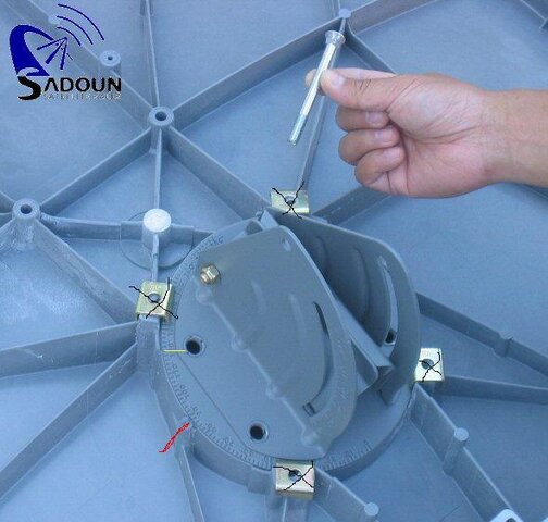
Yes, the skew needs to be set or you may not get a signal. Since Globecast told you to skew dish to 120 that's what you need to do. I'm attaching a pic of the globecast dish with a yellow line showing where 120 degrees is, a red line showing where the referance line is. The 4 black x's are the bolts. Losen the bolts, rotate the dish so the 120 degree mark lines up with the red referance line, and retighten the 4 bolts.
The S (signal) means nothing. The Q (quality) is important. If you have 0% Q that means you are not pointed at the satellite. Keep aiming the dish until you get the highest % of Q that you can get. The lnb is probably fine. When pointing the dish move a very small amount and wait for a second or two to see if Q changes. Then move a small amount again and wait again. Repeat till you get max quality.
The S (signal) means nothing. The Q (quality) is important. If you have 0% Q that means you are not pointed at the satellite. Keep aiming the dish until you get the highest % of Q that you can get. The lnb is probably fine. When pointing the dish move a very small amount and wait for a second or two to see if Q changes. Then move a small amount again and wait again. Repeat till you get max quality.
Attachments
Not the skew I meant elevation first or and also how can i tell when is positive or negative for example i know when the web give it like -42 as a skew mean you have to sub that to 90 if it doesn't have anything mean positive right am i correct
Not the skew I meant elevation first or and also how can i tell when is positive or negative for example i know when the web give it like -42 as a skew mean you have to sub that to 90 if it doesn't have anything mean positive right am i correct
correct. With a dish that can be skewed you take the numbers + - from 90
also, in the pic above the red line is where 90 lines up. It may not be red but should show the indent
No its not red on your dish it is just a line moulded into the dish. It is the reference line because whatever numbered line on the inside lines up with the reference line is the skew of the dish. That dish says 90 when it has 0 skew. If the skew you need is 30 than it is 90 +30= 120. if you aim at a different sat and it tells you to skew -20 for example than it would be 90+(-20)=70.
From your Zip here are your coordinates for G25.
Latitude: 26.1514°
Longitude: -80.2266°
Name: 97.0W Galaxy 25
Distance: 36831km
Motor Latitude: 26.2°
Declination Angle: 4.4°
Dish Elevation: °
Elevation: 54.2°
Azimuth (true): 214.3°
Azimuth (mag.): 220.2° using Compass
LNB Skew: 30.4°
Your skew is 30 so it is 90+30=120.
Your elevation needs to be set to 54 degrees. I always set elevation and skew to what they are supposed to be before pointing the azimuth. That way I know they are close and I shouldn't miss the sat I'm aiming for. Once I peak azimuth I then peak elevation and finally skew.
Last edited:
I try it when i put the dish on top it's doesn't give me anything at all no signal what so ever when i took it off the stand hold it in my hand that's when i get like 40 percent Q i have a 76cm round dish my friend gave me with a invacom uni single lnb which i believe it's ku if i am not correct tell me please and that one does give me a little percent Q when i hold it in my hand but when i put it to the base no Q only S going up n down 75 or 77 person same as globecast one
the globecast dish for some reason that one not giving me anything even when i hold it up, and it's a bring new dish
the globecast dish for some reason that one not giving me anything even when i hold it up, and it's a bring new dish
Listen guys i have found the t5 but for some reason i only can get 77%percent of Q when i hold the dish from the back for some reason at the same direction where i got T5 i have a 98% percent Q but it doesn't give me no satellite name i can only get 77 percent Q with T5 said on top so what do i need to do and other to get stronger Q cause i scanned it with 77% percent Q but the other channel said 66 0r 68% percent which i believe it's 2 low
Not all Sats give a name when locked.i have a 98% percent Q but it doesn't give me no satellite name
Your statement is hard to follow, you could use a few periods.
i have found the t5 but, for some reason i only can get 77%percent of Q. when i hold the dish from the back, at the same direction where i got T5, i have a 98% percent of Q signal. but it doesn't give me no satellite name. I can only get 77 percent Q signal with T5 said on top so what do i need to do and other to get stronger Q signal cause i scanned it with the 77% percent Q signal but the other channel said 66 0r 68% percent which i believe it's 2 low for some other channels or frequencies
As LAK7 said not all satellites send out their names. In fact, very few do. That is why you have to scan a satellite, then check what you get against THE LIST to know where you are.
The name on your satellite list in the set up page, just picks the database the STB will use to try to find TPs, etc. = Channels. So, regardless of what the STB says until you lock the dish down on a satellite signal - only God knows what you are looking at! (Well, not quite, but it does take research). The only one I have seen that consistantly show the names of the satellites are the subscription birds.
The name on your satellite list in the set up page, just picks the database the STB will use to try to find TPs, etc. = Channels. So, regardless of what the STB says until you lock the dish down on a satellite signal - only God knows what you are looking at! (Well, not quite, but it does take research). The only one I have seen that consistantly show the names of the satellites are the subscription birds.
So and other other just scanned it with that percentage than see if i get anything. but how come when i get it on that same direction i got the name with a 77% percent but when i lean the skew a little i got 100% but no name
PLEASE LOG IN TO GET RID OF THESE ADS!
- Status
- Please reply by conversation.
Similar threads
- Replies
- 1
- Views
- 382
- Replies
- 9
- Views
- 932
- Replies
- 19
- Views
- 2K
- Replies
- 5
- Views
- 970
- Replies
- 18
- Views
- 2K