Dish elevation angle (again?)

  • WELCOME TO THE NEW SERVER!

    If you are seeing this you are on our new server WELCOME HOME!

    While the new server is online Scott is still working on the backend including the cachine. But the site is usable while the work is being completes!

    Thank you for your patience and again WELCOME HOME!

    CLICK THE X IN THE TOP RIGHT CORNER OF THE BOX TO DISMISS THIS MESSAGE
Status
Please reply by conversation.

andrew_h

Active SatelliteGuys Member
Original poster
Mar 25, 2011
15
0
Illinois
Hello everyone, I’m new to FTA (and this forum).

I just received the delivery of WS9036 and the 9120 motor. I haven’t actually started the actual installation, but have started mock-assembling the pieces together. There’s one thing that still confuses me: how exactly do I set the dish declination angle? I mean, based on my latitude, I figured out my dish declination angle to be roughly 6.5 deg, so my dish elevation, with that motor, is (40 - 6.5) = 33.5 degrees – now, the problem is the angle scales/notches on the dish bracket don’t have any markings/numbers - how do I know what position corresponds 33.5 deg elevation? (what’s the range, from leftmost to rightmost notch)

I’m looking forward to putting these things together this weekend, would appreciate any pointers here. I’m sure this has been discussed before, my apologies - I’ve searched all over and none the discussions talk not about the physical elevation setup I’m looking for… or maybe I’m missing something here.
 
From my experience over the past 20 years or so, I have found that it is not really necessary to know the exact elevation setting, and the setting on the small dishes that I have had experience with are at best an approximation.

Setting up a movable dish, I would set the actuator to 0 deg, and the dish skew and lnb to 0 deg. This will put everything in the middle. Set the elevation to the closest approximation that you can find listed in charts, books, etc. Then aim the dish (moving the actuator on its mounting pole) approximately toward the satellite that is the closest to due south from your location. It is also very important that your mounting pole is perfectly vertical or else the dish will not properly follow the arc as it moves from side to side.

Take your receiver outside to the dish (if you don't have a meter), and connect the lnb to it. Then go into setup on your receiver, locate an active transponder on this satellite and using the signal meter of the receiver, slowly move the dish up and down (elevation) and the actuator side to side until you find the signal. Then tweak all settings until you have the best Quality.

This has worked for me using a variety of dishes and receivers.

Hope this helps. Good luck
 
Thank you, gentlemen.

Bluztrvler's suggestion makes sense - I'm not sure how successful I would be given my zero experience with all this, but I think I'll give it a try.
 
Set the elevation to the closest approximation that you can find listed in charts, books, etc.

Exactly the question of the op, how to set the elevation angle? Since this dish does not have an dish elevation scale stamped in the bracket, the installer needs to determine the offset angle of the dish and use an angle finder on the vertical the face of the dish. The offset angle of the WS9036 is stated to be 24.62°.

I understand that the 9120 does not have a 40° angle tube. Several threads here on the forum state that the angle is 30°. If so, the dish angle should most likely be set to 23.5°.

Once the dish is mounted on the motor tube and centered (left / right) place an angle finder on the face of the dish and set to -1.12° (Offset angle -24.62° minus desired dish angle 23.5° equals -1.12°). The dish should appear to be pointed towards the ground when pointed at the zero position (true south).
 
Last edited:
Sorry, I missed that point of no numbers on the scale. Of course you are right. My point was that this is not rocket science, and by using a little trial and error, the satellite arc can be located even if you do not know what the elevation setting should be.
 
My understanding was as follows, please correct me if I’m wrong:
Find the closest satellite to my true south, which in my case is Galaxy 28.
Per DishPointer, the elevation for that satellite is 41.5 deg for my position.
The dish elevation (mounted on the motor, centered left-right, aimed at true south) is therefore 16.9 deg (41.5 deg sat elev less 24.6 dish offset) - i.e. the dish will be pointing slightly upwards
(I still need to find a way to measure the upward angle at that 16.9 deg, but I do have something in mind)

Is that not right? The motor tube angle (I assumed) was irrelevant using this method, because I measure the dish elevation directly on the face of the dish.
 
I saw a video on YouTube where a guy was assembling this same dish. He had taken a Sharpie marker and written in the degrees on the gradations that were on the dish. You might want to locate that video. I think the bottom line started at 15 degrees and increased by five degree increments, but I may be wrong. I hope this is helpful.
 
Hello everyone, I’m new to FTA (and this forum).

I just received the delivery of WS9036 and the 9120 motor. I haven’t actually started the actual installation, but have started mock-assembling the pieces together. There’s one thing that still confuses me: how exactly do I set the dish declination angle? I mean, based on my latitude, I figured out my dish declination angle to be roughly 6.5 deg, so my dish elevation, with that motor, is (40 - 6.5) = 33.5 degrees – now, the problem is the angle scales/notches on the dish bracket don’t have any markings/numbers - how do I know what position corresponds 33.5 deg elevation? (what’s the range, from leftmost to rightmost notch)

I’m looking forward to putting these things together this weekend, would appreciate any pointers here. I’m sure this has been discussed before, my apologies - I’ve searched all over and none the discussions talk not about the physical elevation setup I’m looking for… or maybe I’m missing something here.

Andrew,

Hi. Before you begin to question the dish elevation angle setting, do you know how important it is to get your foundation set properly? By the foundation, I refer to the mast being plumb and sturdy and the motor lattitude setting being set as close as possible to perfect agreement with your site's latitude. You may already understand the importance of this, but I must restate it anyway because it is so important.

If you do not already have one, buy a gravity, dial inclinometer from Menards or Ace Hardware or someplace. Slap this inclinometer on the flat of the motor belly and read the angle. Set your motor latitude angle so that the reading on the inclinometer reads 90° minus your site's latitude. (The inclinometer will read the elevation angle and you need to convert that to latitude by subtracting from 90°).

This information has absolutely NOTHING to do with your dish elevation setting, but I just want to stress that these two preliminary setup items are so important. I am stating this not only for your benefit, but for the benefit of all others who may read this thread.

Andrew, you will have to forgive me if this is redundant for you. I just feel that it is SO important and some people overlook it or think that they can slide by without being perfectly accurate on this aspect. Everything you do beyond this point relies totally upon these two setup angles being absolutely perfect. It is very critical.

RADAR
 
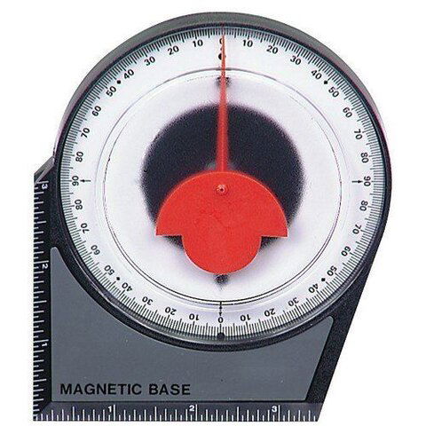
For getting pretty close to required angles, here's an inexpensive device all sat-guys 'n gals need:
Angle meter - Harbor Freight
The picture-link in that thread doesn't work, thanks to the Harbor Freight web site moving it around, so I've added it below.

Of course, inventive members here, have posted home-made tools based on a plastic protractor and a string with a weight on it.

For the more serious, electronic inclinometers with LCD readouts are available:
Angle Meter & Big Button Remote


Attachments

  • InclinometerHarborFreight.jpg
    InclinometerHarborFreight.jpg
    47.2 KB · Views: 262
Actually, I thought we pretty much had this discussion last month.
So, I re-read the thread, and realized the OP had a particular question, which probably wouldn't have been addressed.

STILL, I think a reference to that previous thread, and the one or two FAQs AcWxRadar already wrote on the subject, would have been posted!
I'd have linked it, but cannot find it myself. :(
These FAQs exist for a reason. If they lack details, those should be added.

Now, I'll admit that a dish with no elevation markings is probably not covered by any FAQ, so one can hardly be responsible for such an oversight. - :D
With the variation between motors and their tube angles, maybe an angle-finder-based tune-up document would be useful. :confused:

Some of the alignment documents use keywords that are unfamiliar to newbies.
For all those cases, clear little drawings (or pictures) with big arrows, would make tune-up more clear.
The cost of a single sheet of paper isn't much, so I think we should encourage all our sponsors to include a clear pictorial with each motor and dish.

The same goes for which way to twist C-band LNBFs to set them up initially!
Print it on the box, mark it on the LNBF, or include a half-sheet of paper. - :rolleyes:
If I write a FAQ covering all the available devices, it will not be complementary to the manufacturers! - :rant:
 
I see that Anole is helping out on this project, too! Thanks Anole!

Now we need to figure out how to discern the dish elevation angle - since the dish you have doesn't have the degrees stamped or printed upon it. This is a difficult problem to overcome if you are unfamiliar with sighting your dish in by pure instinct.

Most newbies, greenhorns and first timers want to be as accurate as possible. Without the elevation markings on the dish, you feel lost. But, you can do this all without those markings, if you have patience. Patience is all that is required.

You say that Galaxy 28 @ 89.0°W is your nearest due south satellite. We can work with that very well as there is at least one consistent channel there to play with. NewsOneLive 1 on TP 11955 Vertical with SR 19530Ks/s. This is good and strong for the midwest and for you and I. Is this TP listed in your reciever?

RADAR
 
Actually, I thought we pretty much had this discussion last month.
So, I re-read the thread, and realized the OP had a particular question, which probably wouldn't have been addressed.

STILL, I think a reference to that previous thread, and the one or two FAQs AcWxRadar already wrote on the subject, would have been posted!
I'd have linked it, but cannot find it myself. :(
These FAQs exist for a reason. If they lack details, those should be added.

Now, I'll admit that a dish with no elevation markings is probably not covered by any FAQ, so one can hardly be responsible for such an oversight. - :D
With the variation between motors and their tube angles, maybe an angle-finder-based tune-up document would be useful. :confused:

Some of the alignment documents use keywords that are unfamiliar to newbies.
For all those cases, clear little drawings (or pictures) with big arrows, would make tune-up more clear.
The cost of a single sheet of paper isn't much, so I think we should encourage all our sponsors to include a clear pictorial with each motor and dish.

The same goes for which way to twist C-band LNBFs to set them up initially!
Print it on the box, mark it on the LNBF, or include a half-sheet of paper. - :rolleyes:
If I write a FAQ covering all the available devices, it will not be complementary to the manufacturers! - :rant:

Hi Anole!

I comprehend your statement precisely. I am going out on a limb here and desire to show how the dish can be aligned w/o any support other than the signals from the sky. Will you help me along the way?

RADAR
 
Point your dish

89.0°W is pretty near due south of you, correct? Maybe only a few clicks off at most.

You have a pretty good idea where true south is from your vantage point, so position the dish (the motor and all) to aim in that general direction. You don't have to be accurate right now - just eyeball it the best you can.

RADAR
 
Go into your receiver menus and select Galaxy 28 @ 89.0W. Tell your receiver that you are going to use USALS for locating this satellite and enter your site latitude and longitude as accurately as you can. You will have to use some rounding of the decimal figures, but that is just fine.

Now, command your system to MOVE to that satellite. Your motor should move a few clicks off from ZERO DEGREES or the HOME postion to where it believes this satellite is located. This is normal if your longitude is not perfectly at 89.0°W.

Now we can get down to business. Are you ready?

RADAR
 
Position your dish elevation near about the center of its range of adjustment and use a felt tip marker to mark your position. If you have any embossed markings, aligning to one of them would be better. You just need a reference point to work from.

Are you with me so far?

Next, use your satellite reciever and a portable TV to monitor the signal level and signal quality from TP 11955 VERTICAL from sat 89.0°W.

Pan the entire motor and dish assembly left to right and or right to left very slowly. Move the whole assembly just a couple of degrees at a time and pause. Wait for the receiver to catch up to your adjustments. It may require a few seconds for your receiver to lock onto any signal that is found so give it that time.

If you have gone back and forth from east to west +/- 10-15 degrees from where you know true south should be, readjust your dish elevation up or down two degrees and repeat the east to west panning. Continue this procedure until you lock a signal. Then proceed to fine tune it.

I know this sounds like an unscientific way to proceed, but I gaurantee that it works. Its like the western movies where they use a quick-draw of a hand gun.

You just try it. It is quite simple. Time consuming, yes. Accurate? You bet!

RADAR
 
Thanks again everyone - and esp. RADAR, for the info. I'll take the plunge and will post back with result - good or bad.
 
Status
Please reply by conversation.

Users Who Are Viewing This Thread (Total: 0, Members: 0, Guests: 0)

Who Read This Thread (Total Members: 2)