GeosatPro 90cm reverse elevation

Status
Please reply by conversation.

putney

SatelliteGuys Pro
Original poster
Aug 12, 2009
854
6
St Louis, missouri
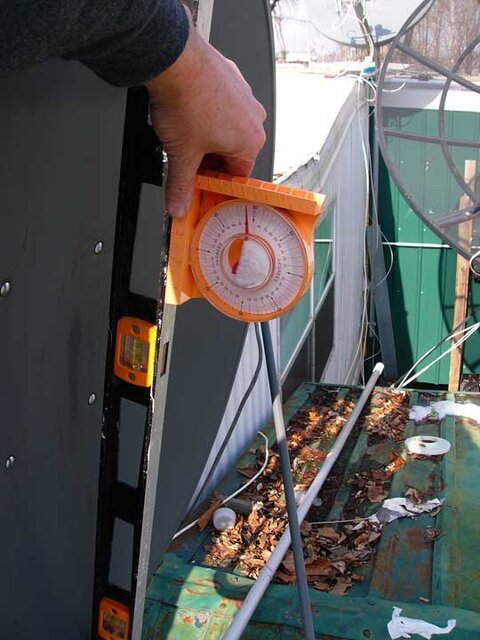
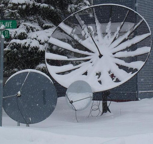
I picked up a GSP 90cm to try to get 30ºw with an elevation of 14º where I live.

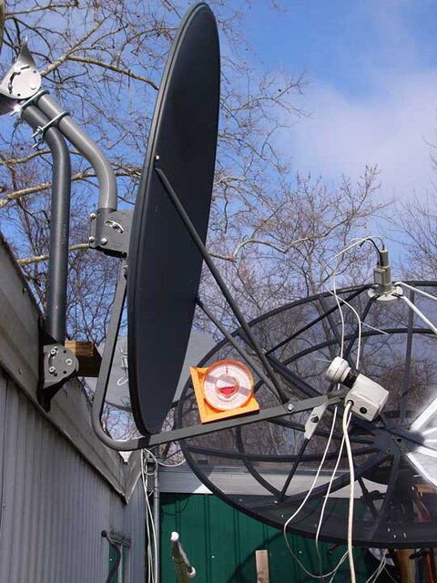
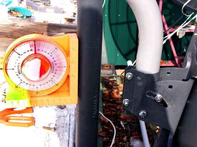
I followed the instructions to reverse the elevation bracket so it will read 0º-20º

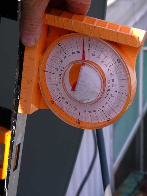
Question: What marks do I use? The manuals I've read say there is no way to use an inclinometer to set this dish, but I dumb and can't figure which pointer to use.

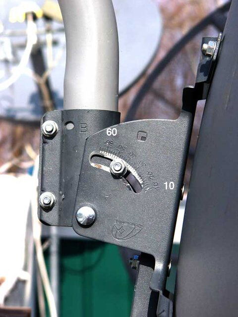
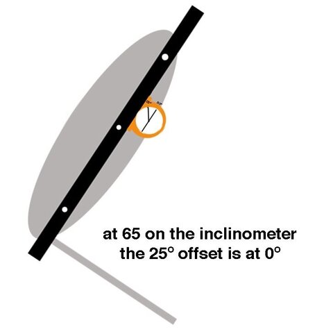
Since pointer 'A' goes to 65, upside down is that 0? And so would 50 be 15 ?

Thanks


http://www.satelliteguys.us/fta-manuals/189795-geosatpro-90cm-offset-dish.html

see 'Z' special elevation
 
Here's what I was thinking. Since the offset of this dish id 24.6º, if I put a straight edge across the face and put and inclinometer on that edge, then if I drop the inclinometer to 25º that should be 0º elevation, right?

So then if I lift the dish 14º that should give me my mark. With 90º being my 12oclock on the inclinometer, 79º would represent 14º latitude. 90-25+14=79

Does that seem right?
 

Attachments

  • 90cm.jpg
    90cm.jpg
    10.3 KB · Views: 144
  • 90cmm_0º.jpg
    90cmm_0º.jpg
    24.6 KB · Views: 155
Last edited:
Here's what I was thinking. Since the offset of this dish id 24.6º, if I put a straight edge across the face and put and inclinometer on that edge, then if I drop the inclinometer to 25º that should be 0º elevation, right?
that sounds right.
If the scale reads satellite elevation, and the offset is X degrees, I think, inverting the dish will result in:
elevation scale minus 2X = actual elevation. I did it a bit different> sideways. Then my offset was to the side, not up, from the face.
 

Attachments

  • aim.jpg
    aim.jpg
    124.6 KB · Views: 154
  • GEDC0641_Crop_small.jpg
    GEDC0641_Crop_small.jpg
    66.1 KB · Views: 140
Last edited:
Putney,

My setup is different from yours as I have my GeoSatPro 1.2 M dish affixed to a motor (DG-380). However, you might find some information here that is useful.
For an inverted mount of this dish, you are to subtract 4.5° from the intended dish elevation to determine what the dish elevation scale should read.
Where I live near Omaha, NE - with my coordinates of 41.6°N / 96.4°W - the dish elevation required (when mounted on the DG-380 motor) is supposed to be 28.56°.
If I subtract 4.5° from 28.56° I obtain 24.06°. This is precisely where my dish elevation is set according to its factory scale.

Since you are setting this dish on a pole and not on a motor (I presume), things are going to change. The dish elevation required is going to be much lower and I don't
recall if the scale on the GeoSatPro goes that low. If I recall, it only is printed down to 10°. However, if it does, your required elevation is 14.37°, subtracting 4.5° results
in 9.87° - which would be what you should see on the factory dish scale if it can be read.

Now, I took some measurements off my system with the motor. Reading 24° on the dish's inverted elevation scale, I also read 34° on the LNBF arm and 76° across the vertical face of the dish using my inclinometer. These values themselves have no meaning to you for your setup. However, you might be able to use the relationship between them to aid you in some way.

I think if you subtract 4.5° from your desired dish elevation (14.37° - 4.5° = 9.87°) and add 10° to this, your inclinometer should read this (19.87°) when placed on the LNBF arm. Add 42° to this and that is what the inclinometer would read across the vertical face of the dish (61.87°).

RADAR
 
With 90º being my 12oclock on the inclinometer, 79º would represent 14º latitude.

Approximately! Good math ...... :D

Tilt the dish top edge forward 10.6 degrees. (24.6 degree (offset angle - 14 degrees (desired elevation setting) = 10.6 degrees )

Radar, not sure about the actual scale reading. I don't have a dish set-up at home with this configuration and don't recall how everything lined up during the testing. :eek:
 
The problem is that when you invert the mount as in illustration 'z' in the above manual, the scale is upside down. That's why I'm left with measuring the angle from the face. (unless SatAV can offer insight into the 0 reference when inverted)


.
 

Attachments

  • inv3.jpg
    inv3.jpg
    59.5 KB · Views: 153
  • inv1.jpg
    inv1.jpg
    46.8 KB · Views: 158
  • inv2.jpg
    inv2.jpg
    36.1 KB · Views: 148
Approximately! Good math ...... :D

Tilt the dish top edge forward 10.6 degrees. (24.6 degree (offset angle - 14 degrees (desired elevation setting) = 10.6 degrees )

Radar, not sure about the actual scale reading. I don't have a dish set-up at home with this configuration and don't recall how everything lined up during the testing. :eek:

And SatAV chimes in before I finish my post! :)

I think I got the same math (after rounding) 90 is the mark on my inclinometer minus 25 (24.6) equals 65 plus 14 equals 79 on the inclinometer

So yes a forward tilt of 11º(10.6º) (I'm not digital)

I did go the right way, didn't I?

Radar, not sure about the actual scale reading. I don't have a dish set-up at home with this configuration and don't recall how everything lined up during the testing.
So if my numbers are correct, inverted on the 'A' scale, 50=0 (on the horizon) and 35=15 (above the horizon)
 

Attachments

  • inv5.jpg
    inv5.jpg
    34.9 KB · Views: 129
  • inv4.jpg
    inv4.jpg
    45.4 KB · Views: 122
  • inv2.jpg
    inv2.jpg
    36.1 KB · Views: 136
Last edited:
Status
Please reply by conversation.

Users Who Are Viewing This Thread (Total: 0, Members: 0, Guests: 0)

Who Read This Thread (Total Members: 3)

Latest posts