Advise needed on my cheap angle finder...

Status
Please reply by conversation.

Wms-Stargate

SatelliteGuys Guru
Original poster
Dec 9, 2016
120
45
East Coast
Now here is the max elevation that I can point this old dish with out any mods. Don't laugh but I wonder if I am even doing this right. lol

So the best way to explain is a picture. The angle finder points to 55...

Whaddyathink guys?

Thanks
Bill
 

Attachments

  • DSCN6608.JPG
    DSCN6608.JPG
    42.3 KB · Views: 211
Several things going on here...

If that is an offset type dish, the elevation angle is the sum of the reflector angle plus the offset angle.

Do not place the angle finder (inclinometer) on the dish face. This is not an accurate way to measure the dish angle as the reflector is a section of a parabolic surface. The face of the reflector is most accurately measured by placing a straight edge on the dish edges, in the center of the dish aligned with vertical axis (6 o'clock / 12 o'clock).

That angle finder is measured the opposite of how you are currently reading it. If the dish is vertical (straight up/down) the reading is 90 degrees instead of 0 degrees. The actual look angle on the offset dish is likely closer to 60 degrees (90 - 55 (inverted elevation reading) = 35 (real elevation angle) + 25 (guesstimated offset angle) = 60 degrees.

BTW, those angle finders are not very accurate. They will get you in the ballpark, but the needle drop can stick and I find that they are usually a few degrees off.
 
BTW, those angle finders are not very accurate. I find that they are usually a few degrees off.

Agreed on those angle finders, however, with the 4 BUDs I've had the pleasure of setting up here at my house NONE of them have worked when setup "by the book" whether using one of those cheap-O magnetic angle finders or the precision machinist square/protractor set in my machinist tool chest. There's always a degree or two difference between what it's "suppose" to be and what actually works.

As usual, your mileage may vary and your prayers will be answered in the order in which they were received! :oldwink
 
Welp since i am certainly a rookie at setting all this up. I have a couple more pictures just so I am crystal.

DSCN6609.JPG
DSCN6611.JPG

DSCN6615.JPG
DSCN6619.JPG
DSCN6624.JPG


In picture three and four I added the measurements that Titanium said would be correct. They came out to be around 57...
Yea i know it's a piece of crap but it will serve it's purpose. If it can get me somewhere in the ballpark. I would be thrilled for the whopping $4.00 that it cost.

1) So does this dish have enough elevation / height in the sky to get all the ku birds? You see i can't adjust it any higher in the sky. It's just not made that way. You see that crazy bracket it has on it right? Anyway as I am looking at all the dishtv dishes on the neighbors house and my own. Those dishes are certainly pointed higher than this one. This one just wont point that high with out hacking on it. Which is not a problem. I would just like to know before I install it.

2) The secondary mounting holes that are kinda in the lower center of the dish. They are not in use and had plastic grommets plugging the 4 holes. Does this dish need those 4 holes blocked in order to receive a proper signal? I just don't know the answer to this...

I am going to buy the dishpointer app again. I just haven't had time. I formatted my laptop hard drive and reinstalled win7. I am just now getting back up to speed.

Thanks in advance for any of your help.
Bill
 
Also titanium I think your saying I need to turn the angle finder. To one of the sides in order to get a proper measurements?
 
So, in pic 3 you are at 57 degrees. Add the 24 degree offset and you are pointing at a satellite 81 degrees in the sky?? Most offset dishes are betwen 24-26 degree offset. Pick a satellite. Take the elevation and subtract around 24 degrees using your method with the inclometer. This will get you in the ballpark
 
  • Like
Reactions: hank123
The effect of the unused mounting holes is cosmetic and will have no effect on the reception.

The satellite closest to true south (the highest satellite for your location Brokenburg, VA) is 77w, but there isn't any FTA KU on that satellite. I would aim for SES2 at 87w for your first satellite as it is near the center of the arc and will be easiest to locate. Use Dishpointer to find the compass reading, elevation and skew setting based on your location:
http://www.dishpointer.com/

Your approximate location information for aiming to the SES2 satellite
Satellite Data Dish Setup Data
Latitude: 38.1456°
Longitude: -77.7192°
Name: 87W SES-2
Elevation: 44.7°
Azimuth (true): 194.8°
Azimuth (magn.): 205.0°
LNB Skew [?]: 11.6°

Aim the dish to approximate compass reading 205 degrees. Identify a landmark in the far distance that aligns with this compass reading (tree, chimney, etc.)
Standing in front of the dish rotate the LNBF in the clamp CCW approximately 12 degrees and slide it forward/aft to the centered position. Slightly tighten the clamp.
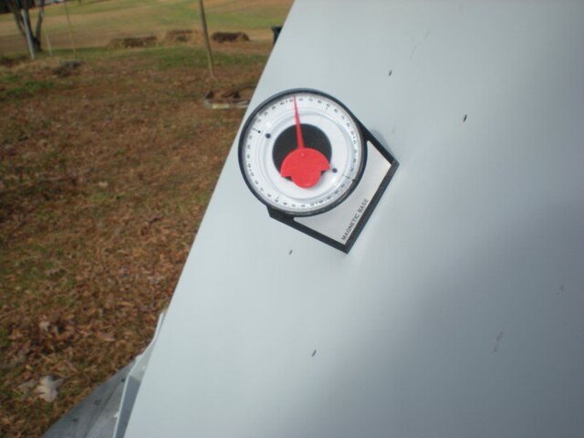
With the straight edge on the vertical axis of the dish, set the elevation to approximately 20 degrees tilted back from vertical, which is 70 degrees per your angle finder (90 - 70 = 20). Here is the math: Satellite elevation angle - Dish offset angle = Angle measured on the face of the dish. Slight;y tighten the securing bolt.

Select SES2 KU in the install menu. Set the LNB LO frequency to match the KU LNB LO frequency (either 10750 or 9750/10600). Set LNB voltage to auto (13/18vdc or Horizontal/Vertical). select transponder or enter transponder: Frequency - 11736 / Polarity - Vertical / Symbol Rate 8333. See www.sathint.com for a list of satellites, transponders and services.

While watching the Signal Quality meter reading on a TV sitting beside the dish, SLOWLY pan the dish East 15 degrees and West 15 degrees from the landmark. The Signal Quality reading will jump when the satellite signal is detected and locked. If no Signal Quality reading is detected, increase or decrease the dish elevation in 1 degree increments and repeat the SLOW East/West pan while watching the Signal Quality meter reading.

Once the Signal Quality has been detected and optimized, rotate the LNBF skew slightly and slide towards or away from the reflector to further optimize. Snug the clamp to secure the LNBF.

Perform a Blind Scan type satellite scan for all FTA channels. When the scan is complete, exit the install menu and engoy watching the programming that you just found!
 
Last edited:
Status
Please reply by conversation.

Users Who Are Viewing This Thread (Total: 0, Members: 0, Guests: 0)

Who Read This Thread (Total Members: 1)

Latest posts