NOAAport help

Status
Please reply by conversation.
Hi Tim

I am thoroughly embarrassed. I have made a MAJOR mistake. I had tuned my USRP receiver to 11994MHz when I wanted to tune it to 1194MHz. For some reason I cant explain, the spectrum of the signal at 11994 was/is extremely complex. It must be coming from the NOAAPORT satellite because the 11994 signal peaks at the same antenna position angle I had set the dish at last year.

When I now tune my receiver to the correct frequency, 1194MHz, I see nothing except noise. When I disconnect the antenna coax from the receiver (USRP) and replace it with a 50 ohm resistor, the noise level retains its shape, but drops about 35 dB.

I apologize for injecting the stupidity in this forum. It could have been alot simpler if I had checked my figures before asking you guys to solve my problems. I still want to learn about the modulation systems used for these weather satellite downlinks. But, I first need to get a sample of the spectrum sent down.

I can get a signal from GOES-11 but dont have any idea how to decode it.

Thanks for 'putting up with me'
Jerry
 
LOL,
Well, it's all part of the learning process, Your embarrassed, look at my first post.
I opened mouth and inserted shoe royaly.
Don't worry about it.

"I had tuned my USRP receiver to 11994MHz when I wanted to tune it to 1194MHz. For some reason I cant explain, the spectrum of the signal at 11994 was/is extremely complex. It must be coming from the NOAAPORT satellite because the 11994 signal peaks at the same antenna position angle I had set the dish at last year."

That's interesting, from what "I KNOW" C band LNB's are not capable of receiving in that high (11Ghz) range.However SES1 is transmitting TV channels on those frequencies. See link below-->

http://www.lyngsat.com/ses1.html

"When I now tune my receiver to the correct frequency, 1194MHz, I see nothing except noise."
As like B.J. said, the USRP is probably not sensitive enough to pick up the weak NOAAPORT signal on that small of an antenna. I doubt my 141T would pick up that weak of a signal.
That is one thing about FEC that I am getting useto myself, Signals that use FEC don't need to be as strong as ones that do, so they don't show up on small antennas using spectrum analysis.
Example.
EMWIN on GOES east (12) (now 13) was just a FSK transmission, With the upgrade to the new satellite NOAA had to reduce the power of the EMWIN transmission to comply with ITU regs.
The reduction of about (I not remembering right now) 3 mabie 6 dB is quite a bit.
The result would be that users wold have to use larger antennas to receive the transmission.
But with using QPSK and FEC the need for a larger antenna is not necessary.
With FEC you can sorta (make up) for the increase in the noise floor, and then with the QPSK you can double the data rate. That's what NOAA did.
The process that this involves is complex.
If I can come up with the article about it in more detail I will post here.
Now that you see noise this could be of good use.
If or what interference your having that is messing up NOAAPORT you should be able to see it.
Especially if you can see the sat card info and the USRP at the same time.
I would keep an eye of the USRP's spectrum to see if anything pops up that looks (out of place).


"When I disconnect the antenna coax from the receiver (USRP) and replace it with a 50 ohm resistor, the noise level retains its shape, but drops about 35 dB."
That is understandable, the LNB has a preamp of nominal 65dB.
So what you see in the spectrum is a heightened noise floor because of the gain.

"I first need to get a sample of the spectrum sent down."

I'll help you with that, I will post some pictures.
But remember, these pics are of a 10' dish.
The sigs. are stronger.

"I can get a signal from GOES-11 but don't have any idea how to decode it."

There are 3 data transmissions on GOES west.
GVAR 1685.7 Mhz , EMWIN 1690.725Mhz , LRIT 1691Mhz
NOTE: EMWIN N , LRIT on the GOES East (13) satellite is different frequencies and formats.
GOES West will change at the end of this year to match GOES East.

Depending of the antenna size your using is what you'll see.
Smaller around 4' antennas will be able to receive EMWIN, LRIT

GVAR is another story. For a quality GVAR recption you should have a 10' dish, though you can get it on a 8' dish.
But if your getting NOAAPORT I strongly would lean that direction.GVAR is a complex format to decode/display. NOAAPORT satellite imgs. are vary similar to GVAR type datasets, in terms of resolution.

Tim
 
Some pics.

Ok,
Here are some pics of the spectrum of the SES1 satellite.
I think it is 2Mhz per div., 10 dB attn.
Pic 1 shows no interference.
Pic 2 shows the same with interference.
I will put more up later. If you have viewing problems due to img. size I will resize them.
 

Attachments

  • ses1 no interference.jpg
    ses1 no interference.jpg
    212.1 KB · Views: 283
  • ses1 interference 1.jpg
    ses1 interference 1.jpg
    197 KB · Views: 237
Question about signals from satellite near 101 E

I am now trying to point my antenna to the NOAAPORT satellite, which I assume is SES-1 at 101 degrees east. I am not sure I have properly attached the picture of the signal I get from a satellite at or near 101 E. The attached picture "2235" is the spectrum, centerered near 1.1994 GHz. The signal is spread over about 3 MHz.
I wonder if anyone knows where this "11994" signal is coming from?
Attachments "2242" shows my Twinhan display. Attachment "2243" shows the USRP display and is an 8 MHz wide spectrum centered on 1.194 MHz.

Very slight change in pointing of the dish will result in lost LOCK. But, the Strength doesnt drop below max.

Jerry
 

Attachments

  • CIMG2235.JPG
    CIMG2235.JPG
    34.3 KB · Views: 256
  • CIMG2236.JPG
    CIMG2236.JPG
    40.6 KB · Views: 246
  • CIMG2243.JPG
    CIMG2243.JPG
    33.3 KB · Views: 269
Yes, NOAAPORT is on SES1.
Picture 2235 looks to be SES1, I have seen that "4" signal complex on my analyzer here. the one farthest to the right I believe is one of the HITS channels

Your twinhan display looks good for a 7.5' dish to me.

Picture 2243 shows what looks like NOAAPORT.
I am impressed it shows up better than I would have thought.

"Very slight change in pointing of the dish will result in lost LOCK. But, the Strength doesn't drop below max".

Again signal strength is, Like we said before just an indicator of signal present. B.J. summed it up well.
But with antenna that small I can understand that it is very (touchy) when it comes to signal lock.
As was said earlier, everything will have to be at optium. Aiming, noise, setup exc.
Your 2243 picture there.
The signal in that picture should remain "as is" at all times.
If an interference is messing up the reception you WILL see it.
There should be no (jagged points) shooting up or around the NOAAPORT signal. Like you see in my second pic.
Or the ambient noise floor shouldn't jump up and cover the NOAAPORT signal.
You have a nice display there.

Tim
 
Hi Tim

I do have difficulty accepting that the Twinhan bars display only "the presence of signal". I have seen the bars vary with antenna angle changes. Right now, the Quality bar is jittering about 10% up and down. But, the fact is - I dont know anything about either the Twinhan Strength or Quality.
The Strength was 100% and Quality varied between 75% and 90% last year before I disconnected the NOAAPORT system. At that time, all the images were clear and unbroken. Now, the quality is down to about 35% to 45% and the images are terribly broken.
I need to learn more about what effects the receiver's capability to decode the NOAAPORT signals.

Jerry
 
More pictures

Hi Jerry,
Here are some more pictures of the SES1 spectrum.
Pic: Screen shot
This is a screen shot like yours, Shows strength/quality and channels on NOAAPORT

Pic: Noise nothing
This the the spectrum analyzer running wih nothing connected to it, Just showing the ambient nose floor.

Pic:1 Ghz sweep
This is a 1 Ghz sweep of the SES1 spectrum, centered on 1194Mhz
Shows all the nifty stuff coming out of SES1 and how the noise floor rises due to the preamp.

Pic: 500 Mhz Sweep
500 Mhz Sweep of the SES1 spectrum, centered on 1194Mhz
otherwise same as above.

Pic: 100Mhz Sweep
100Mhz Sweep of the SES1 spectrum, centered on 1194Mhz
Otherwise same as above

Pic: 20 Mhz Sweep
20 Mhz Sweep of the SES1 spectrum, This shows NOAAPORT centered on the screen with the UCTV of the the left side.

Pic: 1400Mhz
A 10 Mhz sweep of the SES1 spectrum centered near 1400 Mhz.
This seems to show something sim. to what you posted IMG2235

One change that occurred from last year to now is the satellite changed.
AMC4 was decommissioned an replaced by SES1, I don't know if that has anything to do with it.
also my quality bar jitters too by about 10%.
Otherwise I don't know.

Tim
 

Attachments

  • Screen shot.JPG
    Screen shot.JPG
    216.7 KB · Views: 236
  • 1400 Mhz.JPG
    1400 Mhz.JPG
    161.7 KB · Views: 237
  • 100 Mhz Sweep.JPG
    100 Mhz Sweep.JPG
    172.2 KB · Views: 237
  • 1 Ghz sweep.JPG
    1 Ghz sweep.JPG
    158 KB · Views: 243
  • 500mhz sweep.JPG
    500mhz sweep.JPG
    173.4 KB · Views: 225
  • 20Mhz Sweep.JPG
    20Mhz Sweep.JPG
    152 KB · Views: 186
  • Noise nothing.JPG
    Noise nothing.JPG
    177.8 KB · Views: 225
Hi Tim

I do have difficulty accepting that the Twinhan bars display only "the presence of signal". I have seen the bars vary with antenna angle changes. ....

I don't think anyone was trying to say that the Twinhan S/Q bars won't change with tuning changes to the dish/polarity, etc. It's just that the S/Q bars on ANY consumer DVB receiver are only relative, and have no absolute meaning. Ie you can't look at the reading you get on the Twinhan and compare it to the reading someone else gets on any other receiver and conclude that you have a good or bad signal. The readings are only relative to the Twinhan you're using. I use the Twinhan S/Q bars to peak my dish all the time. I was just trying to suggest that the S/Q numbers that I get on MY Twinhan (which is a 1020a BTW) are much lower than the numbers I get with other receivers on the same signal, even though the Twinhan does just a good or better job of actually receiving the signals. Ie it's not that the Twinhan tuner is weak, it's just that the S/Q numbers don't have any absolute meaning, they are only relative.
 
Hi Tim

I assummed that the green bars in the Twinhan were intended to display the levels of S and/or Q into the receiver system being adjusted.
When I set up my system, I used the S bar to adjust the pointing direction of the antenna and to set the polarization. It was a coincidence that, when I peaked the S, the Q bar was near 90%.
Now, I can get the S bar to max but have no idea what I can do to improve the Q bar length.

Jerry
 
Hi Jerry,
First a agree with you 100% B.J. and I just posted pics to show how my system is working here.
Doesn't mean that yours is going to work like mine or vice versa.

Something you can try Jerry, I saw it on here.
I don't know if you using the vertical or horizontal polarization.
But is was mentioned earlier here that horizontal works better due to voltage at the LNB.
I was having issues with the signal dropping out when I peaked the antenna on the bird, I didn't understand why, I had a real good signal and the signal just dropped out, dissappered. What?
Well a little research found as mentioned, the voltage on the vertical side 12.5V or near that was not enough to keep the feed alive so I changed to horizontal and found the system works much better at the 15 to 16V range.
You can try that to see if it helps anything.

"It was a coincidence that, when I peaked the S, the Q bar was near 90%"

I never used the S Bar here just the Q bar. The S bar once on the arc of satellites was always running high.
The quality bar showed when I had a lock (getting data) and the quality of the data.
Then I just peaked the quality from there.

"Now, I can get the S bar to max but have no idea what I can do to improve the Q bar length"

If I knew how to improve the quality bar I would do it here, The only thing here that improved quality by about 3%
was "me" standing facing the dish off the the left side at the edge holding my hands up and slightly moving them around while listening to the beeping of the radio.
What was this doing you ask? Well, I assume that it my have caused better reflector illumination or maybe blocking a noisy side lobe. I really don't know.

I know that you had the signal a year ago, that was a year ago not now.
I will put in a quote from the SBN (NOAAPORT)

Date: Tue, 20 Apr 2010 18:20:24
From Brian Gockel email Brian.Gockel@noaa.gov
"4. Dish Size (from the lead AWIPS hardware engineer: we use 2.4 Meters typically, but 3.8 Meters in some cases)."
Jami Casamento, copied on this email, is the NWS comms engineer for NOAAPort.

I got this from them (SBN) when I was having my rash of problems.

Tim
 
Hi Tim
I messed alot with my dish and feed yesterday. Nothing improved the Quality I changed the LNB and tried for over an hour to turn the antenna to improve the Quality. Nothing seems to get the Quality back up where it was.
I like the spectrum analyzer images you sent. I tried to show what My USRP displays, but, the widest spectrum I can sweep is 8 MHz. Another problem with using the USRP as a spectrum analyzer is the gain of the USRP droops at the edges, so even a constant signal level into the receiver displays as a slight hump, maybe 3 dB from edge frequency to center frequency. I swept 4 spectrums, 8 MHz each so I could show you the 32 MHz around the NOAAPORT frequency.
Also, I noticed that the Quality on my Twinhan (1020A) is only about 10% lower than you showed.

I adjust the polarization using a pot on a circuit I made for turning RC servos. With this circuit I can turn the polarization to mak the signal.

Jerry
 
out of ideas

Hi Jerry
Thanks for the spectrum analyzer complement, Hope it can help in some way, with others too.

"I messed alot with my dish and feed yesterday. Nothing improved the Quality I changed the LNB and tried for over an hour to turn the antenna to improve the Quality. Nothing seems to get the Quality back up where it was."


"I adjust the polarization using a pot on a circuit I made for turning RC servos. With this circuit I can turn the polarization to mak the signal."

That's nice to have, but
you don't need to change the polarization at the dish leave that vertical or where the best quality you can get, But change the (vision data software) to horizontal and click apply.
When you do that it changes the voltage supplied to the feed.

If that does nothing to help in reception quality and
If all has been eliminated and it seems that it has, If anyone on here has got a 7.5' dish in service for NOAAPORT please come forward and give some detail.

Otherwise.... If it were ME in that situation and the info I have it's time to go to at minimum an 8' dish, knowing you have done everything you can do with that 7.5 dish
Cause somewhere you not getting enough signal to keep a lock on NOAAPORT
And looking at what you have posted for spectrum analysis that is the only other idea I have.


Quote from Skysurfer
"btw, you asked about my numbers, I'll give you the info for my "smallest" c-band dish. 8.5' dish, corotor II+ feedhorn with c/ku LNBs, motorized so it's not a fixed type dish, and I get a 99 Quality, 75 signal on my PCI card for NOAAPORT (and a 11.0 CN on my portable signal meter readout)"

The quote from Skysurfer blows my system out of the water for quality, But as B.J. said systems differ one to another, in every way.

"I noticed that the Quality on my Twinhan (1020A) is only about 10% lower than you showed."

Ya I know, I doesn't seem like much but it's the difference of having a solid lock to an intemittent one.

Tim
 
Hi Tim

I think is time for me to drop this investigation into NOAAPORT Quality using the Twinhan. As I understand it, NOAAPORT plans to change to a different signal modulation format within a year or sooner.
My interest in NOAAPORT and all other weather satellite is restricted to receiving images with a minimal $$ investment. I have no need for the NOAA data. I would like to learn as much as practical about the various weather satellite systems so i can help others get signals from them. There would be no need for me to enter this forum, asking questions, except that the NOAAPORT signals are interesting to Patrik Tast who wants to refine his software for decoding the NOAAPORT data.
At this time, the Twinhan Strength is MAX and the Quality is 44%.

Jerry
 
Hey Jerry,
Please don't get too frustrated, I do know that this can be a pain.:(
I don't think you should quit looking into the quality issue, you may find out
something we all don't know.
I'm sorry if I can't explain what you looking for, because I don't know myself.
What I do know that dish size does affect quality.

"As I understand it, NOAAPORT plans to change to a different signal modulation format within a year or sooner"
So as to what I have herd too. DVBS-2
A link about that format.
http://www.dvb.org/

"My interest in NOAAPORT and all other weather satellite is restricted to receiving images with a minimal $$ investment."
I see that your a ham, so am I and hams are resourceful.
I see that you yourself have no need for the data but here are some ideas I really want you to consider, if you want to continue pursuing this.
1.
Talk to the local ham comm. see what others have for dishes laying around, mabie you can barter to get the dish you need, even sometimes you explain what your looking for someone will outright just give it to you.

2. Get creative.;)
You already have 7.5' dish so get creative, I'm gonna get an ear full for this on here.
Do you have duct tape and Window screen, mabie some stiff tin foil?
All you need to do is add 3" of reflector to the edge of the current dish, POP now you have an 8' dish.
After adding to the reflector you will have to recalculate the focal length, it's not hard and I have the formula for that.
You may have to make the feed structure a little longer if you can't adjust to the new focal length.

Here are some things I have done here to "make it work"
I use 1/2" emt conduit for feed supports, My EMWIN dish feed structure was too short to accommodate the L band feed (which I also homebrewed) so I made the feed support structure longer.
And I can tell you it works fine, it is one of the current systems I am using.

For NOAAPORT I had to make the the feed horn longer and make my own chaparral choke ring.
For making the feed longer I used a (think) 1 1/4" long piece of copper ring taped to the end of the horn with that aluminum ductwork tape, the choke ring I made out of copper sheet and is clamped to the outside of the horn with a hose clamp.
I could have used that aluminum tape but I wanted it adjustable.
Oh, and I also had to make a adaptor fit the L band feed support so I could use the C band feed.
That is the current system I am using

"I would like to learn as much as practical about the various weather satellite systems so i can help others get signals from them"
Here is a link to the GOES data book, this describes all the info you would want + more.
GOES ,POES
http://www.osd.noaa.gov/GOES/goes_n.htm

"NOAAPORT signals are interesting to Patrik Tast who wants to refine his software for decoding the NOAAPORT data."
Here would be the link for Patrick to understand the NOAAPORT data form what I have found.
http://www.nws.noaa.gov/noaaport/html/noaaport.shtml

"At this time, the Twinhan Strength is MAX and the Quality is 44%."

Your quality is only abut 5% too low right now to get a solid lock.
If you don't ask questions you can't get answers.
I wish I would have had this when I was getting started.
I'm happy to help.:D

Tim
 
Last edited:
Hi Tim
You have been a good source of the information I was looking for. The other NOAAPORT groups are more interested in using the data from the satellite for weather recording. I dont really care about monitoring weather. I got interested in weather satellites when I learned that it is possible to receive VHF signals to produce pictures of Earth as seem from space. When I was developing a VHF satellite antenna, I met Patrik, in Finland, who was experiencing great difficulty while trying to build a good antenna for APT imaging. Since then, I have been trying to help Patrik with signal reception.
NOAAPORT signals are not available to Patrik so I assembled some low cost stuff here in California to get some signal from the NOAAPORT satellite. Patrik then wrote the programs for decoding it.
The NOAAPORT reception system I first set up worked quite well using the 7.5 foot dish and Twinhan PCI TV. Patrik was able to write the program for using ONE Windows computer for producing images from the NOAAPORT satellite.
After we had demonstrated that a 7.5 foot dish and a Windows computer, with a low cost PCI TV could be used to receive and decode NOAAPORT signals, I figured we had finished the job. I disconnected the C-band system early this year because there was near zero interest in the project Patrik had done.
Recently I acquired a USRP and am now attempting to make data available from as many weather satellites as I can. Patrik is trying to learn to write the programs to instruct the USRP to receive the various weather satellites and then decode them.
Many years ago, I was employed to design antennas and, once, a receiver for the USN. But, I am way to disconnected from the technology of today. I cant figure out these "BPSK, QPSK, DVB-S and etc" modulation systems and am too old to want to study them.
I will drop this effort to learn what effects the Twinhan Quality. It is too complex for me and I dont have the motivation to study DVB-S, especially when the SES-1 will soon abandon the DVB-S.
I have plenty of projects like HRPT antennas and GOES antenna systems that I may be able to help Patrik with.
Again, I thank you for the guidance you have given me.

Jerry
 
Here is some more info Jerry
this is a power point file on NOAAPORT
http://www.weather.gov/datamgmt/slide_show/BrianGockel062509.ppt

I never used the polar weather satellites, I was looking for something that stayed in the same place.
That is when I decided to go with the GOES satellites, or geostationary satellites.
APT is about as old as WEFAX and no longer used on GOES, has been replaced by LRIT
Low Resolution Image Transmission
This is a digital format, and higher res. than wefax.

Then you have EMWIN
Emergency Managers Weather Information Network
19.2 Bps QPSK FEC
I have 3,000 + files from this service, It has an assortment of products from all the text bulletins to graphic products and is quite fast Esp. with the last upgrade.
It is a much smaller version of NOAAPORT. and more costly.
Looking around min $1000.00 now on the Comm. market.
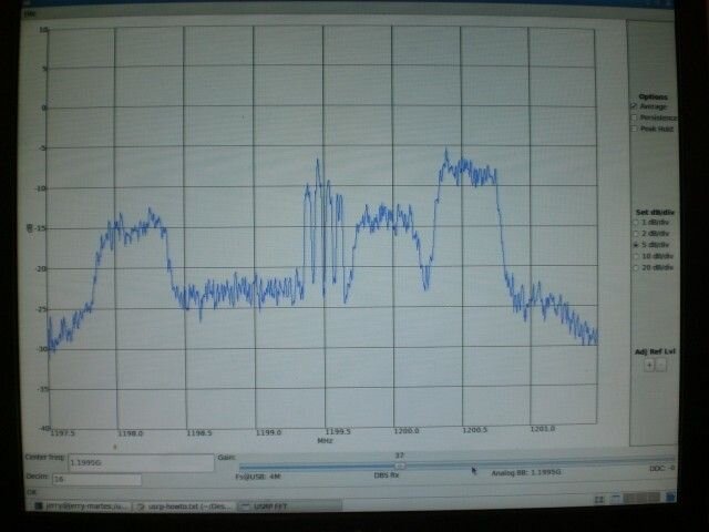
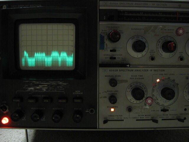
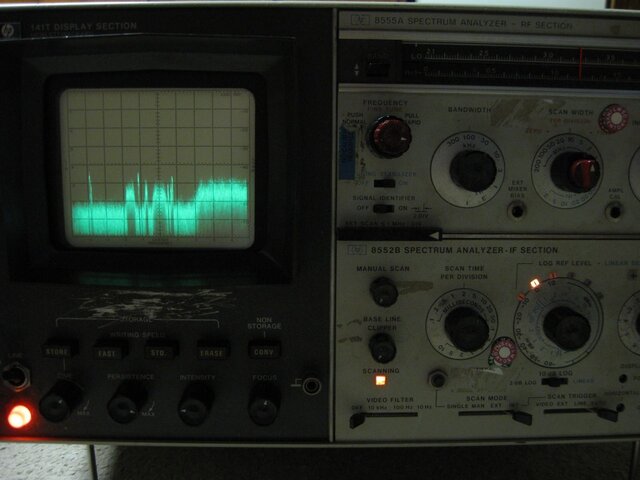
GVAR
GoesVARiable
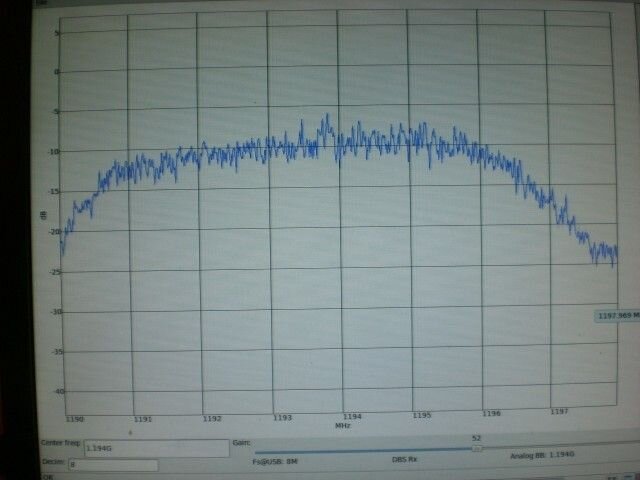
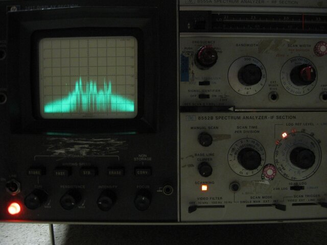
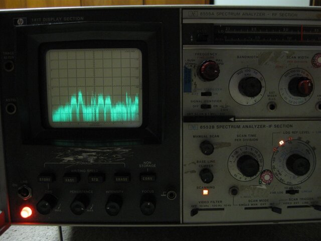
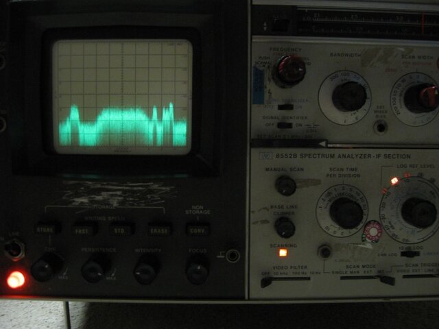
This is the processed imager and sounder info on GOES, comes at 2.11 Mbs BPSK
1685.7 and is 4 Mhz wide signal.
These are NOT imgs, they are calibrated points and temperatures that are plotted to make an image.
Known as Gridded data, from what I have been told this is an old format.
When displaying this data you can see GPS coordinates and on the IR images temperature of that pixel.
As I said this is not an easy to decode data, That is why I perfer NOAAPORT.
The system I use here is made comm. made by Automated Sciences LLC.
I know of no one that has made a homebrew GVAR station.
and is way out of the price range of the hobbyist.
looking at a nominal $7000.00, they use to be $20,000
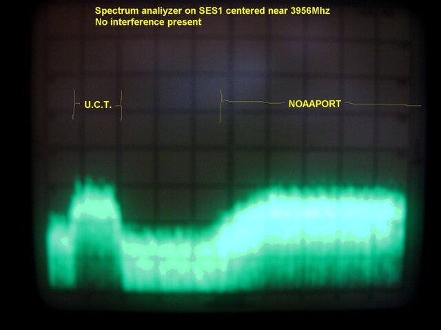
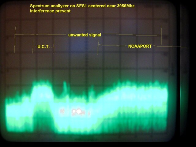
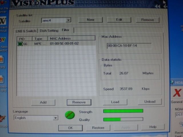
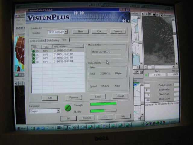
NOAAPORT
DVB-S soon DVB-S2
This is weather data relayed through a comm. satellite.
This is the gateway into NOAA and almost all of it's products, which is a H*LL of lot of them.
That's why there is so much data coming off NOAAPORT, it covers all the regional NWS offices + National and some overseas.
But the way that they (NWS) makes this data available is quite cheap compared to other systems out there and the products available.
The formats they use can be decoded fairly easily, exp. satellite imgs.
also the gear to receive this is readily there.
Unlike the the L band, it getting harder to come by and more costly.
Sorry guys it's true

I have invested around $300 into my NOAAPORT, At that small of a price to get a massive amount weather data from satellites, I about wet my pants!

Also a big plus, Unlike GOES you get one or the other depending on what bird your on NOAAPORT you get bolth and more.
The NOAAPORT satellite imgs. are timely, No delay or very small, there transmitted as soon as the GVAR image is done.
I use this data here to watch the weather. It's one of my loves.
Also to help the local hams when spotting.

The simple thing to understand about BPSK,QPSK, and so fourth is amount of data that can be transmitted. The more phase changes that occur the more data that can be transmitted.
But there is a trade off, the higher the phase changes the probability that you can get errors.

I'm No tech. but I believe that I need to be able to take care of my setups and manage them so I need to understand them a little.
I'm glad that you and Patrick are working together to make software, that is the only way the market is going to be there for this.
Otherwise cost will be a factor.
And I say Thank You

Good luck on HRPT, here is a link to RIG
Remote Imaging Group
http://www.rig.org.uk/

there is tons of info on there.
I have a couple of their old mags. and they are really good.

Don't be a stranger here
come by again.

Tim
 
Quality bar using Twinhan PCI receiver

Hi Tim

I disconnected the NOAAPORT (Twinhan) system a few weeks ago when it became obvious that the Quality of the signal received here with my smallish (7 1/2 foot) dish was too poor to provide data for reliable images. I picked up a 9 foot solid surface dish this week-end. That renewed my interest in NOAAPORT, so I powered up the Twinhan. To my surprise, the Quality was/is up to 50% with the old (7 1/2 foot) dish. Thats enough to provide continuous lock.
Is the Quality at your station slightly higher now as compared to a few weeks ago?

Jerry KD6JDJ
 
Signal strength

Hi Jerry,
I was just about to contact you and ask you if you were getting a stronger signal.
My signal had increased around 10% here. I have seen this before and it's doesn't last.
In fact I just looked before I posted and it was back to normal.
the increased signal quality lasted for two days here.
I still recommend putting up the bigger dish, You will like your outcome.

Tim
 
Status
Please reply by conversation.

Users Who Are Viewing This Thread (Total: 0, Members: 0, Guests: 0)

Who Read This Thread (Total Members: 1)

Latest posts