Question about Magnetic Declination Help?

Status
Please reply by conversation.

jdc2006

SatelliteGuys Family
Original poster
Dec 30, 2006
44
0
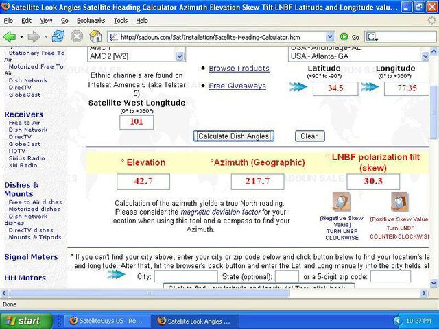
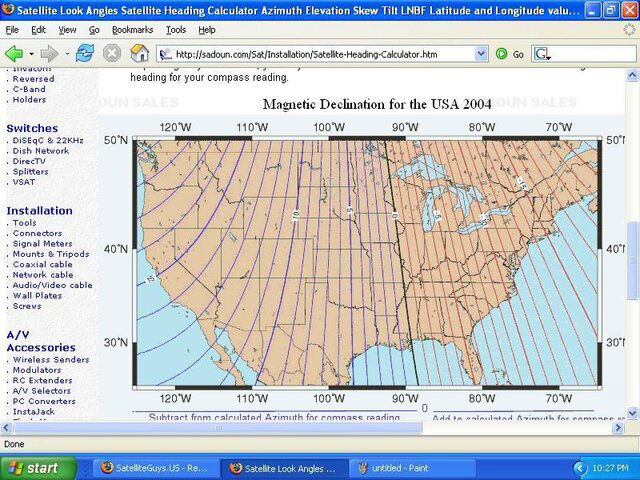
So I've been installing Directv sats for four months now. Before I started I didn't have the first clue about installing dishes. Never installed one in my life. I didn't really get much training one week to be exact. I have a question about magnetic declination. My lat and long are as follows 34° 51.744' North and 77° 35.178' West my declination comes up to -10.05. I use a birdog signal meter which is great for the directv 101 sat because when it says found you know your on the correct satellite. I know other sats don't have distinctive signals the birdog can decode so if your not pointing the dish in the right direction you may be looking at the wrong bird. Here is my question. When I look up the azimuth and elevation for the 101 its as follows for my area, True Azimuth is 217 and Mag. Azimuth is 227. My trainer told me 227, which from what I'm reading that is wrong. I should actually be pointing at 217 degrees am I correct? I use a Suuden Tandem inclinometer and always look at 227 for Line of sight. Am I wrong? I looked up the specs on the inclinometer and it doesn't allow for adjustment of the magnetic declination, so basically I'm looking at magnetic poles and will have to adjust for the declination. As long as I'm in the approximate area I can adjust the azimuth of the dish to peak the signal with no problem with directv. If I'm doing it all wrong than it will be a problem when I try to do a site survey and or peak FTA signals. Please help and explain if i'm doing this all wrong.

So have I been doing site surveys and dish pointing inaccurate this whole time?
 
Here is my question. When I look up the azimuth and elevation for the 101 its as follows for my area, True Azimuth is 217 and Mag. Azimuth is 227. My trainer told me 227, which from what I'm reading that is wrong. I should actually be pointing at 217 degrees am I correct? I use a Suuden Tandem inclinometer and always look at 227 for Line of sight. Am I wrong? I looked up the specs on the inclinometer and it doesn't allow for adjustment of the magnetic declination, so basically I'm looking at magnetic poles and will have to adjust for the declination. As long as I'm in the approximate area I can adjust the azimuth of the dish to peak the signal with no problem with directv.

you have to take magnetic into account. So if your mag declination is +10, then you have to add 10 to most readings unless they take it into account

I ran the numbers for 101 for your area and I get
42.7 elevation
217.7 geographic azimuth
227.7 magnetic azimuth

See the below pictures. The number for azimuth is geographic so you have to add 10 to all your numbers for your location. For me (45N 93.5W) I have to subtract 2 to my numbers so for me its at 215. On your inclometer, you have to take into consideration magnetic. So you need to look at 227
 

Attachments

  • untitled.JPG
    untitled.JPG
    102.5 KB · Views: 256
  • untitled2.JPG
    untitled2.JPG
    115.1 KB · Views: 249
Something's gone out of whack with the term "Magnetic Declination".

For hundreds of years the term has been "Magnetic Deviation" in North America. The redefination seems to have taken place only recently (past several years) by satellite enthusiasts in North America, Europe, and Asia.

Surveyors deal with magnetic deviation everytime they setup their instruments. The term they use (in North America) is "Magnetic Deviation".

I guess it must be part of the "Metrification" of our part of the world; like from degrees F to degrees C, yards to meters, and inches to centimetes. You know the story.
 
I always liked the term magnetic deviation because that way it does not get confused with the declination angle used as part of the set up of moveable dishes so they will track the Clarke belt.
 
I'm with CAdata, and Determined on this one.
I'm a magnetic deviation advocate, and the use of declination doesn't belong in the same sentence. ;)
 
Actually, the US Guvmint uses the term magnetic declination. http://www.ngdc.noaa.gov/seg/geomag/declination.shtml

Magnetic deviation is the error in a compass reading due to some local perturbation in the earth's magnetic field due to such things as a large amount of iron ore in the ground, rail-road tracks, etc. It can also refer to the errors remaining after compensating a compass on a vehicle/boat.
 
Just wanted to verify if this is right. I'm in Los Angles.

The Geo Azimuth for IA5 is 145.1.

My Mag Dev is 13.2 E. Does that mean my Mag Azimuth is 131.9 and this is what I should point my compass to?
 
you are correct

Yes.

See the IA5 (97ºw) line in the satellite list I gave you in your other thread.
Notice the azimuth true and azimuth magnetic for that bird differ by about 14º.
That is in close agreement with your numbers.

It is unlikely you will get closer than 2º, and will have to fine-tune anyway, so don't get too anxious over small differences.
These tables and calculations are just a good place to start.
Manufacturing tolerances in dishes are another source of small errors.
 
Last edited:
Status
Please reply by conversation.

Users Who Are Viewing This Thread (Total: 0, Members: 0, Guests: 0)

Who Read This Thread (Total Members: 1)