
Need help pointing to G10
- Thread starter thisBUDsforyou
- Start date
- Latest activity Latest activity:
- Replies 42
- Views 5K
You are using an out of date browser. It may not display this or other websites correctly.
You should upgrade or use an alternative browser.
You should upgrade or use an alternative browser.
- Status
- Please reply by conversation.
Great tip! I went to Amazon and found this angle locator:
Amazon.com: Johnson Level & Tool 700 Magnetic Angle Locator: Home Improvement
And guess who wrote the first customer review!
Excellent tool
We use this for satellite dish installation, and we are very please with its quality and durability. It is not like the cheap imported models. This is much more precise and the scale if very easy to read. We highly recommend it to all of our dish installers. For the price and quality, it is a 5 stars no doubt.Best regards
Sadoun Satellite Sales
Gotta have that tool, mine is a Craftsman from Sears. It's 20 years old now, used alot.
")
Wow, you found our review from a few years ago. Well, the review still stands. Johnson Level & Tool good ol' American quality is top.
Here is the link to the level from our store.
iafirebuff, I am not sure how Farm and Fleet sells it for $6? That is seriously below our cost. You must have bought it on sale.
Here is the link to the level from our store.
iafirebuff, I am not sure how Farm and Fleet sells it for $6? That is seriously below our cost. You must have bought it on sale.
Nope, regular price. They are identical to the Johnson Level only they have a black case. No matter what brand you get, I would say that this is a MUST have tool for everyone's"satellite" tool box - which is something else everyone should have - a tool box that is dedicated to satellite tools. I have one with all the tools that I use when I tinker, plus I also have spare LNB's (THANKS SADOUN for you .99 auctions!), F connectors, splitters, diseqc switches, sat meter, etc. All in one box - grab and go! I can take my box of coax (THANKS AGAIN to SADOUN!), my tool box and an extension cord and away I go
Wow, you found our review from a few years ago. Well, the review still stands. Johnson Level & Tool good ol' American quality is top.
Here is the link to the level from our store.
iafirebuff, I am not sure how Farm and Fleet sells it for $6? That is seriously below our cost. You must have bought it on sale.
They are identical to the Johnson Level only they have a black case.
Ok, now that explains it. It must not be a Johnson (Johson's is Yellow), but the cheaper one which we used to sell.
What am I doing wrong?
Gave up on G10 for now. Moved over to G25 at 97, much higher in the sky. I've got indication of signal, high 80's, low 90's but no matter what I do I can't get quality over 30. I've tried tiny increments left and right, up and down, and left and right on skew. What else can I try?
Gave up on G10 for now. Moved over to G25 at 97, much higher in the sky. I've got indication of signal, high 80's, low 90's but no matter what I do I can't get quality over 30. I've tried tiny increments left and right, up and down, and left and right on skew. What else can I try?
This is weird. I still can't get more than about 28-29 quality but I did a power scan and got about 190 TV channels and a bunch of radio channels which are watchable and seem to come in pretty steady, no dropouts. I thought you had to have quality in the 40's to lock on a signal. Guess not.
Yes, but I don't really know how to read the marks on the LNB and LNB holder. The LNB holder has +20 and -20 marks. For 97 the skew was +23 so I turned it counterclockwis a little past the 20 mark. I was fiddling with it to try to get the best signal but I was still getting dropouts on the weaker transponders.
Finally! Threaded the Needle on G10!
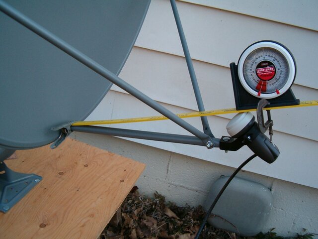
Finally figured out a spot where I could see G10. The first picture shows what I was dealing with, a big ole oak tree across the street and a big maple in the neighbor's yard on the right. That little patch of clear sky in the middle is where G10 is. With my homemade inclinometer I figured out that those trees in the distance in the middle of the picture were low enough that I could see over them.
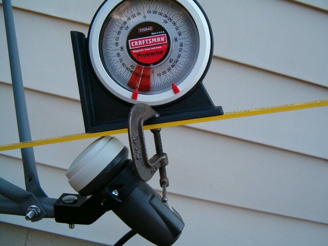
I ended up buying the Sears Craftsman angle finder in the pictures. What I like about this one is the little red markers that slide around to mark the angle you want. The elevation indicators on the dish just aren't accurate enough. Without one of these angle finders you're flying blind, IMO.
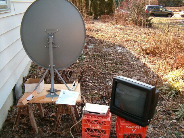
The last picture shows my lashup setup on the ground. Since I was right next to a window I passed the cable into the house and actually watched sat TV in a warm place for the first time.
Unfortunately, I'm beginning to suspect that a motor may not be the way to go for me - haven't found a place on my property yet where I can see the whole arc.
Finally figured out a spot where I could see G10. The first picture shows what I was dealing with, a big ole oak tree across the street and a big maple in the neighbor's yard on the right. That little patch of clear sky in the middle is where G10 is. With my homemade inclinometer I figured out that those trees in the distance in the middle of the picture were low enough that I could see over them.
I ended up buying the Sears Craftsman angle finder in the pictures. What I like about this one is the little red markers that slide around to mark the angle you want. The elevation indicators on the dish just aren't accurate enough. Without one of these angle finders you're flying blind, IMO.
The last picture shows my lashup setup on the ground. Since I was right next to a window I passed the cable into the house and actually watched sat TV in a warm place for the first time.
Unfortunately, I'm beginning to suspect that a motor may not be the way to go for me - haven't found a place on my property yet where I can see the whole arc.
Attachments


I'm confused
Not sure of the basis for the assumption, but can see some fallacies in the implementation.
For one, the LNB horn diameter as well as its in/out placement, will vary your angle.
Also, on dishes which don't have tripod LNB-mounting (side stabilizer struts), the LNB could be high or low by a number of degrees, which is the basic reason the dish elevation marks are in error.
I remembered this comment, and now I see ThisBUD has photographed the idea.... So I reset my elevation placing a yard stick from the bottom lip of the dish to the top on the lnbf.
Then I put my inclinometer on the yard stick and set my elevation angle exactly to what my satellite calculation program on my computer said.
Then I slow moved the dishes azmuith and bang it was there.
Not sure of the basis for the assumption, but can see some fallacies in the implementation.
For one, the LNB horn diameter as well as its in/out placement, will vary your angle.
Also, on dishes which don't have tripod LNB-mounting (side stabilizer struts), the LNB could be high or low by a number of degrees, which is the basic reason the dish elevation marks are in error.
I remembered this comment, and now I see ThisBUD has photographed the idea.
Not sure of the basis for the assumption, but can see some fallacies in the implementation.
For one, the LNB horn diameter as well as its in/out placement, will vary your angle.
Also, on dishes which don't have tripod LNB-mounting (side stabilizer struts), the LNB could be high or low by a number of degrees, which is the basic reason the dish elevation marks are in error.
By using my method it will get you pretty close in the ballpark. The markings on my G10 dish are off so I can't go by them. That method worked well for me. It gives you the approx 22 deg offset.
I see what your saying and are correct that certain variables can give you false readings, although it should get you closer than just sliding the dish up & dn and back & forth.
So I guess I should ammend my instructions that you may have to slide the elevation up or down also a little bit to lock on bird. The LNB dish combo I used it was close enough to get the quality meter singing.:up
Last edited:
I ended up buying the Sears Craftsman angle finder in the pictures. What I like about this one is the little red markers that slide around to mark the angle you want. The elevation indicators on the dish just aren't accurate enough. Without one of these angle finders you're flying blind, IMO.
That's the one I have, it has served me well.
When I first tried this (on G25 yesterday) I didn't remember the description of the method correctly and put a straight edge across the reflector from top to bottom. That didn't work AT ALL and I realized that gave a totally different angle than what was on the elevation marks. Next I ran the straight edge from the top of the dish down to the LNB and that worked and for some strange reason gives the same angle as you get when you go from the bottom of the dish to the LNB. Today when I was trying to get G10 the dish was mounted on plywood up on sawhorses which I didn't make much of an attempt to get really level (I did put a piece of wood on one side to shim it up to where it looked approximately right) - the point being that there was no reason to think that the elevation marks on the dish were even close to being right. So using this yard stick and protractor method will get you close enough to get signal, which is most of the battle. You still have to tweak it from there, in tiny little increments. For the elevation I just leaned on the dish a little up or down to see which way to adjust it - it was just a tiny little adjustment needed from where I had set the elevation originally.I remembered this comment, and now I see ThisBUD has photographed the idea.
Not sure of the basis for the assumption, but can see some fallacies in the implementation.
For one, the LNB horn diameter as well as its in/out placement, will vary your angle.
Also, on dishes which don't have tripod LNB-mounting (side stabilizer struts), the LNB could be high or low by a number of degrees, which is the basic reason the dish elevation marks are in error.
The way I have used an inclinometer, is by using the offset degrees of the dish (Azure Shine 90cm is 24.6°) subtracted from my desired elevation and using that number for the front of the rim of the dish. So if I wanted 33° elevation I would take 33°-24.6°=8.4°. On my inclinometer, vertical reads 90°, so 90°-8.4°=81.6°. I set the red marker to 81.5°, stick it to the front/side of the rim (using the magnet) and I am ready to set my elevation.
Note: this only works on dishes that don't skew.
Bob
Note: this only works on dishes that don't skew.
Bob
now we're talkin' !
Well, I'm in favor of every trick that gets you in the right ballpark.
I know I've used poor tools at times (or none), and let the frustration get to me.
So, anything that keeps you from going too far astray is a good thing.
WescoPC's description is very clear, and should get you right on the money.
If someone would add a picture of how to hang the inclinometer to the edge of the rim to demonstrate it's position, I'm sure it would help everyone.
Inclinometers are inconvenient when we want to call 0° vertical, and not horizontal.
You'd think they'd make a model for us odd folks!
Luckily, a bit of adding and subtracting before you take your numbers out to the yard, should give ya a real edge.
The way I have used an inclinometer, is by using the offset degrees of the dish (Azure Shine 90cm is 24.6°) subtracted from my desired elevation and using that number for the front of the rim of the dish.
So if I wanted 33° elevation I would take 33°-24.6°=8.4°.
On my inclinometer, vertical reads 90°, so 90°-8.4°=81.6°.
I set the red marker to 81.5°, stick it to the front/side of the rim (using the magnet) and I am ready to set my elevation.
Note: this only works on dishes that don't skew.
What happens sometimes when we use no tools is that were just fishing in a big pond, and get lost very easily. The yardstick, inclinometer trick gets you back on track. Unless your very lucky your not going to get a signal without setting some sort of static (start) points. Even on my 90 cm Primestar which has an excellent elevation adjustment and a quite accurate meter on the dish you have to tweek from static points. It's just the nature of the beast.
Sometimes when I post stuff I don't cover every detail & angle of what Im trying to say. (my bad) I assume that the one reading it can read between between the lines and figure out the rest. I have a very technical background and forget that everyone don't understand things on the level others with that background and training would. (my bad again)
Sometimes when I post stuff I don't cover every detail & angle of what Im trying to say. (my bad) I assume that the one reading it can read between between the lines and figure out the rest. I have a very technical background and forget that everyone don't understand things on the level others with that background and training would. (my bad again)
You lost me here. Where do you get the offset degrees of the dish? Where do you put the angle finder? Can you post pictures of how this works? ThanksThe way I have used an inclinometer, is by using the offset degrees of the dish (Azure Shine 90cm is 24.6°) subtracted from my desired elevation and using that number for the front of the rim of the dish. So if I wanted 33° elevation I would take 33°-24.6°=8.4°. On my inclinometer, vertical reads 90°, so 90°-8.4°=81.6°. I set the red marker to 81.5°, stick it to the front/side of the rim (using the magnet) and I am ready to set my elevation.
Note: this only works on dishes that don't skew.
Bob
You lost me here. Where do you get the offset degrees of the dish?
That you would have to get from the spec's sheet or manufacturer. They usually use a 22 degree offset on offset dishes as a guideline. (some higher some lower)
- Status
- Please reply by conversation.
Similar threads
- Replies
- 159
- Views
- 6K
- Replies
- 11
- Views
- 800
- Replies
- 8
- Views
- 531
- Replies
- 1
- Views
- 529