Anole said:
. . . and it's all discussed on
Geo-Orbit, too.
Using the lower table, I get about 3.866° .?.
I was wondering just how accurate does the declination and elevation angles have to be. But, since these are just starting points, both can be fine tuned to get the greatest accuracy.
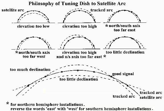
The pole must be plumb!
The declination is set correctly once, and left alone.
If you need to fiddle with elevation, check your LNBF centering on the dish.
Twist the mount on your pole to bring in the ends of the arc.
Don't forget to focus, and adjust the f/d (scalar).
Oh, and skew, too.

If you watch those boresight videos you will pick up that the angle settings are just a starting point. If you go to one extreme of travel you adjust the azimuth. At the top of travel you adjust the elevation.
......
That's why spending a tone of dough on digital angle gizmos is a waste of time and money. Eventually you are going to discard them and get into tweaking and adjusting.
I think that the order you do things is real important, and also, you should try to be as accurate as possible with your angle measurements, or you will be in an endless loop of tweaking. You really can't start with the extreme/azimuth adjustment. You have to do things at the top of the arc first like ANOLE said above. With a prime focus dish, I agree with the order Anole gave.
But with a prime focus dish, if you take care to get the declination proper as accurately as possible to the 2nd "modified" table a geo-orbit, it really turns into a 3 or 4 step process as Anole described. The only tweaking involved is peaking the elevation on the south sat, and tweaking the azimuth on the extreme sat (in that order). If you use the 1st non-modified table, then you will be off by 0.6 deg after the first 2 tweaks, and you'll need to go back and forth a few times to get it right, and the tweaking often gets out of control and you make it worse. I think the digital levels are relatively cheap now, and are worth the investment to help you get the initial declination right, but only IF your dish has appropriate places to put the level on. My current BUD does NOT, so the digital level didn't help me as much as I had hoped. However a check for the declination is if after you've peaked the elevation, your 90 minus your elevation angle should be about 0.6 deg more than your latitude, and I WAS able to use my digital level for THAT measurement.
The above being said, on an offset dish, it is usually easier to accurately set your elevation angle first, again generally about 0.6 deg greater than your actual latitude subtracted from 90 deg. Then do the peaking using the declination adjustment, which is generally the "dish elevation" on those small dishes. It's better to do it this way, because the motor elevation can be set MUCH more accurately than the declination with these dishes, and the motor elevation can usually be done with a digital level to save on the amount of tweaking requirred.
I agree with Anole that with a prime focus dish, set the declination, then never touch it again. With an offset dish, set the motor elevation, then never touch it again.
The only other thing I would suggest, is that when adjusting the Azimuth on an extreme sat, it often works better if you go back and forth a couple times, adjusting the azimuth, then peak via running the motor a few clicks, then re-adjust the azimuth, and peak via motor a couple clicks. This is because if your azimuth is off quite a bit, very often peaking via just turning the mount on the pole doesn't take you to the desired adjustment in one step. Also, after the azimuth adjustment, you'll generally have to re-sync the arc if you have saved satellite positions, since this adjustment will alter the positions of all saved sats along the arc.


