Declination Angle

Status
Please reply by conversation.

qwerty81

SatelliteGuys Family
Original poster
Feb 27, 2006
41
0
I live at Location
Latitude: 26.4036°
Longitude: -80.2061°

What is the correct declination? Is there a calculator? I am using a polar mount on a 7.5 mesh dish.

Correct me if I'm wrong but the main bar in the middle of the mount, should that be set to my Latitude?

Thanks
 
. . . and it's all discussed on Geo-Orbit, too.

Using the lower table, I get about 3.866° .?.
See if that agrees with the other site Greg listed above. (I may have made a mistake) - :cool:

edit:
Other site says 3.87° , so we seem to agree.
 
Last edited:
I was wondering just how accurate does the declination and elevation angles have to be. But, since these are just starting points, both can be fine tuned to get the greatest accuracy.
 
in this order?

The pole must be plumb!
The declination is set correctly once, and left alone.
If you need to fiddle with elevation, check your LNBF centering on the dish.
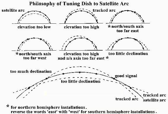
Twist the mount on your pole to bring in the ends of the arc.
Don't forget to focus, and adjust the f/d (scalar).
Oh, and skew, too. :)
 
If you watch those boresight videos you will pick up that the angle settings are just a starting point. If you go to one extreme of travel you adjust the azimuth. At the top of travel you adjust the elevation.
Watch this video
http://boresight.ripco.com/
Shaun Kenny - Tracking Made Easy (TRT 00:15:15)

That's why spending a ton of dough on digital angle gizmos is a waste of time and money. Eventually you are going to discard them and get into tweaking and adjusting.
 
Last edited:
Anole said:
. . . and it's all discussed on Geo-Orbit, too.

Using the lower table, I get about 3.866° .?.


I was wondering just how accurate does the declination and elevation angles have to be. But, since these are just starting points, both can be fine tuned to get the greatest accuracy.

The pole must be plumb!
The declination is set correctly once, and left alone.
If you need to fiddle with elevation, check your LNBF centering on the dish.
Twist the mount on your pole to bring in the ends of the arc.
Don't forget to focus, and adjust the f/d (scalar).
Oh, and skew, too. :)

If you watch those boresight videos you will pick up that the angle settings are just a starting point. If you go to one extreme of travel you adjust the azimuth. At the top of travel you adjust the elevation.
......

That's why spending a tone of dough on digital angle gizmos is a waste of time and money. Eventually you are going to discard them and get into tweaking and adjusting.

I think that the order you do things is real important, and also, you should try to be as accurate as possible with your angle measurements, or you will be in an endless loop of tweaking. You really can't start with the extreme/azimuth adjustment. You have to do things at the top of the arc first like ANOLE said above. With a prime focus dish, I agree with the order Anole gave.
But with a prime focus dish, if you take care to get the declination proper as accurately as possible to the 2nd "modified" table a geo-orbit, it really turns into a 3 or 4 step process as Anole described. The only tweaking involved is peaking the elevation on the south sat, and tweaking the azimuth on the extreme sat (in that order). If you use the 1st non-modified table, then you will be off by 0.6 deg after the first 2 tweaks, and you'll need to go back and forth a few times to get it right, and the tweaking often gets out of control and you make it worse. I think the digital levels are relatively cheap now, and are worth the investment to help you get the initial declination right, but only IF your dish has appropriate places to put the level on. My current BUD does NOT, so the digital level didn't help me as much as I had hoped. However a check for the declination is if after you've peaked the elevation, your 90 minus your elevation angle should be about 0.6 deg more than your latitude, and I WAS able to use my digital level for THAT measurement.

The above being said, on an offset dish, it is usually easier to accurately set your elevation angle first, again generally about 0.6 deg greater than your actual latitude subtracted from 90 deg. Then do the peaking using the declination adjustment, which is generally the "dish elevation" on those small dishes. It's better to do it this way, because the motor elevation can be set MUCH more accurately than the declination with these dishes, and the motor elevation can usually be done with a digital level to save on the amount of tweaking requirred.

I agree with Anole that with a prime focus dish, set the declination, then never touch it again. With an offset dish, set the motor elevation, then never touch it again.

The only other thing I would suggest, is that when adjusting the Azimuth on an extreme sat, it often works better if you go back and forth a couple times, adjusting the azimuth, then peak via running the motor a few clicks, then re-adjust the azimuth, and peak via motor a couple clicks. This is because if your azimuth is off quite a bit, very often peaking via just turning the mount on the pole doesn't take you to the desired adjustment in one step. Also, after the azimuth adjustment, you'll generally have to re-sync the arc if you have saved satellite positions, since this adjustment will alter the positions of all saved sats along the arc.
 
talkin' BUDs only:

- I wasn't giving a step-by-step like BJ did (so well)
- just answering the OPs question, "how accurate does the declination and elevation angles have to be?"
( declination: very ... elevation: as required )
- the long answer was to be found on the Geo-Orbit site; it's quite a reference
- as for what did we do?, there are lots of ways to skin the cat - I think the OP now has plenty of ammo to deal with his dish - :up
- hope the video by Shaun didn't confuse anyone. - ;)
That's why spending a ton of dough on digital angle gizmos is a waste of time and money.
Eventually you are going to discard them and get into tweaking and adjusting.
The final solution is an art-form. Accurate settings are a starting point.
What you do with 'em is up to the patience of the adjuster (can't use the word tweaker, here) - :)
 
.....
- hope the video by Shaun didn't confuse anyone. - ;)

I don't have enough bandwidth here to view videos, so I didn't look at it.
I was just curious.... isn't that the guy who used to have the show on sat with a girl, and he got killed by falling off his roof or something like that?? Or am I thinking of someone else?
 
The pole must be plumb!
The declination is set correctly once, and left alone.
If you need to fiddle with elevation, check your LNBF centering on the dish.
Twist the mount on your pole to bring in the ends of the arc.
Don't forget to focus, and adjust the f/d (scalar).
Oh, and skew, too. :)

It seems that there's more than one technique for doing the alignment. Some say to set declination/elevation, then go to the one or both ends of the arc and move the mount, and then go back and check elevation, and repeat (that's what my Paraclipse manual says to do). Some say that the elevation should be set only once and then the azimuth is set only once.

It's interesting to note that the declination chart in my Paraclipse manual shows a declination of 5.79 for my latitude (42) while other publications show 6.489. I ran the numbers in a program that yielded 6.475 for declination (my actual latitude is 41.83). The Paraclipse uses shims to set declination so it can't be made exact anyway. Anyway, I don't have the original shims to correct this issue. Oh well, I'll have a replacement antenna up in about 3 weeks. Hopefully, I'll get it right this time. :)
 
The 5.8 degree difference is the correct number.
Make sure that there is just under 6 degrees of drop between your polar mount and the reflector, when centered at due south. Then set the elevation so that you get a signal on a due south satellite.
 
good advice is hard to find,,, apparently:

It seems that there's more than one technique for doing the alignment. ...
... Some say that the elevation should be set only once and then the azimuth is set only once.
I've never seen nor heard that idea expressed.

It's interesting to note that the declination chart in my Paraclipse manual shows a declination of 5.79 for my latitude (42) while other publications show 6.489.
I ran the numbers in a program that yielded 6.475 for declination (my actual latitude is 41.83).
The manual is right - no surprise there! - :eek:
As for "the other publication" and the "program", all I can say is that the reference material I used ...
... Geo-Orbit table at the bottom of the page...
... came up with about 5.8 degrees (I didn't do the math).
So, it helps to know where to look for good advice. - :rolleyes:
The 5.8 degree difference is the correct number.
Make sure that there is just under 6 degrees of drop between your polar mount and the reflector, when centered at due south. Then set the elevation so that you get a signal on a due south satellite.
Think that says it all! - :cool:
 
...
It's interesting to note that the declination chart in my Paraclipse manual shows a declination of 5.79 for my latitude (42) while other publications show 6.489. I ran the numbers in a program that yielded 6.475 for declination (my actual latitude is 41.83). .....

The reason for the two declination values is that the 6.475 value is the declination of a sat to your south, and the 5.79 value is the declination of a sat to your extreme east or west.
If you use the 6.475 value, it will work OK when you're aiming near your south sat, but you will be off by the nearly 0.7 deg difference whenever you try hitting a sat to your east or west, and there is no way to correct this.
If you use the 5.79 value, however, it will work fine when aimed to the east or west, and you CAN correct for the error on southerly sats by decreasing the inclination (increase your latitude value) by that 0.7 deg difference. The inclination correction doesn't affect the adjustment near the extremes since it's an orthogonal motion, and it's effect is applied proportionally across the arc, depending upon how far you are from south, so the result should be that you are accurate to at least 1/10 deg and probably better than that.
Done this way correctly, and you really shouldn't have to do any back and forth re-adjustment. If you use the 6.475 value, you'll find out that you're off on the east or west, and end up going back and forth, and hopefully end up with the 5.79 value after hours of adjustment.
 

OK. Apparently they're showing 2 sets of declination tables. One for a standard polar mount and the other for a modified polar mount. That's where I got confused. The formula that I used to calculate declination was for a standard polar mount - I don't see anything in the books appendix for a modified polar mount formula. I'm glad I picked up your posts before running out to change the declination angle. :) Anyway, I checked the declination using an inclinometer (per Paraclipse manual instructions) and it's around 5.6.

Thanks everyone!
 
Bottom of the page

Footprints by Dish Size - Adjusting the Polar Mount for Prime Focus Antenna - C/Ku-Band Satellite Systems - Tuning, Tracking, Azimuth, Elevation, Declination Angles, F/D Ratio, Focal Distance, Inclinometer, LNB/Feedhorn Assembly, Actuator Assembly, C


adjarcsr.JPG
 
Q: What did we all do before digital crap came along?
A: We used technique and talent.

I agree. But, all these neat tools make the job so much easier. But, I sometimes find it hard to justify spending all that money - for sat peakers, inclinometers, laser focus finders, etc - just for the stuff to collect dust most of the time. That said, it's probably cheaper to buy the tools instead of paying someone to come out and align the antenna for you (that is, if you can find someone to align a big dish these days).

Hmm, I just remembered, I have access to a Birdog since I install Hughesnet stuff at work...... :D
 
Status
Please reply by conversation.