Declination Angle

  • WELCOME TO THE NEW SERVER!

    If you are seeing this you are on our new server WELCOME HOME!

    While the new server is online Scott is still working on the backend including the cachine. But the site is usable while the work is being completes!

    Thank you for your patience and again WELCOME HOME!

    CLICK THE X IN THE TOP RIGHT CORNER OF THE BOX TO DISMISS THIS MESSAGE
Status
Please reply by conversation.
OK. Apparently they're showing 2 sets of declination tables. One for a standard polar mount and the other for a modified polar mount. That's where I got confused. The formula that I used to calculate declination was for a standard polar mount - I don't see anything in the books appendix for a modified polar mount formula. I'm glad I picked up your posts before running out to change the declination angle. :) Anyway, I checked the declination using an inclinometer (per Paraclipse manual instructions) and it's around 5.6.

Thanks everyone!


If you read through this, it does not refer to two different mount types but rather the difference between calculated dec angles (we used to call the "look angles") and the dec angle that yields the best results (therefore "modified")

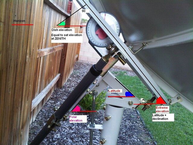
In summary, the declination angle lowers the satellite antenna from looking into deep space
to look at the arc of geostationary satellites. However, upon
practice, it has been discovered that using the latitude as the
elevation angle, (first chart below),
the satellites at the top of the arc, in a tracking mount system,
were in perfect alignment with the satellite dish, i.e. were
tracked perfectly by the polar mount, whereas the satellites
at the lower ends of the arc where not tracking correctly. Conversely,
if the satellites at the ends of the arc, on the horizon, were
tracking correctly then the central satellites, at the top of
the arc would be slightly off target. This effect is caused by
the slight deviation from the true north/south line, caused by
the act of the tilting of the dish, as the dish moves to view
satellites lower on the arc, i.e. closer to the horizon. With
this in mind, it was formulated the elevation/declination angles
of the modified polar mount (second chart
below) whose application has no effect on seeing satellites
at the top of the arc but has the effect of better tracking on
the sides and low end of the arc. This effect is accomplished
by slightly increasing the elevation angle and accordingly slightly
decreasing the declination angle by the same amount. Use elevation/declination
settings from the modified polar mount
chart (second chart below) when installing and adjusting
your polar mount tracking system - compare the values of the
two charts below to see the difference in elevation and declination
angles. Note: Elevation and declination angles are always
measured and applied when the dish is at its zenith, i.e. highest
point in the arc, when the dish axis is aligned along the true
north-south line. (Applying
declination/elevation angles.)
 
OK. Apparently they're showing 2 sets of declination tables. One for a standard polar mount and the other for a modified polar mount. That's where I got confused. The formula that I used to calculate declination was for a standard polar mount - I don't see anything in the books appendix for a modified polar mount formula. I'm glad I picked up your posts before running out to change the declination angle. :) Anyway, I checked the declination using an inclinometer (per Paraclipse manual instructions) and it's around 5.6.

Thanks everyone!

Trying a different way of explaining the two tables. There is no such thing as a modified polar mount, it's just that the modified tables are better, and the only way to actually track the arc.
Most of the manuals for satellited dishes use the non-modified tables, because it is an easier calculation ( to calculate the declination of your true south satellite), and for C-band on an 8-10' dish, being off by 0.6 deg wasn't that big of a deal back in the analog days, and being off by that much on a 3' Ku dish isn't that big of a deal either, on analog.
However with for Ku on a BUD, or DVB-S2 on anything, you need more accuracy. Many people start out with the standard tables, then go to the extremes, and follow a complicated procedure of pulling down or pushing up on the dish to see if things improve or not, and the result telling them whether they should increase or decrease declination, or elevation or azimuth, and do a lot of back and forth adjustments, and *IF* these adjustments are successful, they will end up with giving you the same declination/inclination that is listed in the modified table anyway..... so why not just start with those. If you start with the modified tables, it's a 3 step process, and you are done.
It has always amazed me that 98% of the satellite aiming charts, and on line calculators and such seem to use the standard declinations, and tell people to use their latitude on the latitude scale or 90 minus latitude on elevation scales, etc, when that is definitely NOT the proper angle.
That geo-orbit page has been around for close to 15 years or so, and for years, it was the ONLY document out there (other than my own mini-web page) that seemed to understand the process.... I take that back, I think the Arc-Set guy understood it too. Anyway, that's why I always refer people to the Geo-orbit page. At least it has the tables there, although it really doesn't attempt to explain WHY the tables are necessary, which is because the true south sat is closer to you, and thus has a higher declination than any other sat in the arc.... so why choose the declination of one satellite, and have all other sats wrong ?????
Sorry for rambling. It's just that I've never figured out why companies would sell dishes, then give incorrect instructions for aligning them.
 
Trying a different way of explaining the two tables. There is no such thing as a modified polar mount, it's just that the modified tables are better, and the only way to actually track the arc.

What? Everything I've read says there IS a modified polar mount and it is defined as a polar mount with a declination adjustment.
 
Q: What did we all do before digital crap came along?
A: We used technique and talent.

with analog signals you could almost wave the dish around in the sky and get something LOL. now you have to "lock" the signals and be above the digital threshold not counting the seconds it takes for most receivers to recognize the signal after you are on it.

Just wait til everything in the sky is tight fec'd dvb s2, dish pointing will be real fun then.:rant:
 
. . . and it's all discussed on Geo-Orbit, too.

Using the lower table, I get about 3.866° .?.
See if that agrees with the other site Greg listed above. (I may have made a mistake) - :cool:

edit:
Other site says 3.87° , so we seem to agree.

I am trying to get my 10' mesh dish aligned to the arc. I've been working almost all day every Sunday and some weekday afternoons for almost four weeks and haven't gotten it right yet. I found this thread today that has clarified several things for me.

I may be missing the obvious but I would like to get some additional clarification on a few points stated in this thread.

Originally the guy's latitude was 26.4036 deg, if you look at the modified polar chart:

Footprints by Dish Size - Latitude Declination Chart - C/Ku-Band Satellite Listing

the row for 26 reads 26.56 angle and 3.81 offset. How was the above 3.866 calculated?

Is there a formula listed somewhere that will allow me to calculate the modified polar declination offset based on my latitude of 33.5219 or do I just have to estimate it somehow from the chart? Does anyone know how the charts values were calculated originally?

Based on the chart (row 33) my modified alignment is 33.60 angle and 4.79 offset for a total measured angle of 38.39 deg. As I understand it the offset is reduced by the same amount that the angle is increased, I'm not sure how much my offset needs to be reduced based on my 33.5219 latitude?

Also, when making my elevation adjustments on the highest elevation satellite before moving to the lowest western sats for the azimuth adjustments, do I make the adjustments on whatever satellite is closest to my dishes "zenith" position or on the satellite that is closest to the "true south" for my location? For me Nimiq 4 is at azimuth 180.41 (186.81 with mag dec.) which I believe is my true south satellite. However, that satellite is off to the western side of my dishes zenith position. I will have to try to figure out which satellite is close to my dishes zenith position if that is the one I need to adjust with. Hopefully I have explained myself clearly.

Thanks for your time.
 
Although a satellite dish is a fine instrument, in fact, it is exacting only as well as the installation; that is, if the feed horn is not perfectly point to the exact center of the dish, at the right focal point; all numbers of any other spot you measure it at, like where the dish mounts to the pivot point; will be off as much as the feed horn is off. With bolting anything, you will find, there is almost no tool that can exactly measure the angle within the allotted points it has to measure with. The true declination of a satellite dish, is "the flat plate of the dish"; that is the point in the sky the dish is receiving the signal from, measured at the feed horn and how flat it mounts to the dish. So, if you measure at the flatness of the scalar rings, then the "stringed dish plate" as a completely flat plate; these two measurements should be the same; and then your pivot point measurement, +- the dish plate/feed horn measurement; this is your declination that has been set. On your measurement tool, can you read any angle below one, that is, how fine is it to smaller than one degree? Fine tuning from there will make the declination finer and finer, but only if you move it very little. Same with zenith; how well can you read and compare where the "mount" is pointing. Applying most tactics will get you within a degree or better; which will be close enough to receive the signals from the satellites, but not very perfectly, because every tune must be sung; that is, everything must then be perfected from imperfect "close" settings, so that the entire assembly is within the lowest tolerances of measurement, say within .1 (one tenth of a degree); then you'll find that it works better as a complete polar "ARCED" assembly, and if you can, if you get the tolerances within .01; the wind will push hard enough to make it move off .5 degrees, and it will not matter....And there are not many satellite dishes that are strong enough not to flex, that are tight enough, steel strong enough, pole that won't flex; ETC; to make up for that .1 -> .5 degrees of differences, making it impossible to put a dish within the required tolerance required for reception of every satellite signal. A satellite dish of 6' also has about a 3 degree "beamwidth"; which negates many exactnesses your polar mount is being set to, including declination. This 3 degree's is basically "sloppiness"; and applys to all the satellite points it is trying to pick up; so even if you get the mount to perform within a degree of tolerance, it is still picking up signals from outside of that fine pointing, it does.
So, for now, it is always close by measurement, and exactly tracking Clarke's Arc of satellites is getting it as exact as possible using a polar mounting of a satellite dish, and it will track as perfect as Clarke's arc is using a satellite dish of about 40 foot in diameter (needs more exact arc numbers), smaller than that, it is close, and good enough...True south is another number that is not talked about enough, because truely, south and north is not magnetic, it is "true" only when you add or subtract the magnetic deviation for "you're just a spot on the map"; and deviation of the true south/north line therefore must be determined by moving the compasses reading a little degree or more east or west...
 
Last edited:
Does anyone know how the charts values were calculated originally?
Algebra?
Being this is a two year old thread, I will post this picture and that's all. I think the Mods will suggest starting a new thread.
 

Attachments

  • polar_mount_pic.jpg
    polar_mount_pic.jpg
    152.9 KB · Views: 248
SatScanner - give us your exact zip code or city.
We can confirm your numbers for where you actually are.
If it was in your post, sorry - put it in your "location" so we can find it. :)

As stated above, you dial in the dish as best you can with the tools you have, and the tables you can find.
Then, you fine tune any dish, peaking it in actual service.
Worrying about the last 0.1° is pointless, since it's doubtful most of us can measure -accurately- anyway. :rolleyes:
Some first-class BUDs shipped with bolt holes spaced 0.5° apart for setting declination.
Birdview dishes were pre-set with around 5°, and the installer used washers as shims if needed! :eek:

As to the numbers I gave in the quote above, . . .
I probably did a simple interpolation between two adjacent numbers from the table.
That was two years ago. ;)

Thanks. My zip is 29851. I could try to post some pics of my dish later on if that will help with my questions.
 
Personally, I have had bad luck with the lower chart. They often say that about five degrees is OK. I have a Birdview that is set to five degrees and have not had the best of luck with fine adjustment with washers, so can attest to five degrees being pretty good for me. I am however closer to 35 degrees latitude so you are further south and would therefore require less declination.

I would go with about 4.5 degrees per the upper chart.

The first thing I would look at is where I could get the acccurate measurements on an inclinometer. For that, you have to have your dish at apex. It's good if you have an indicator mark on your mount somewhere to indicate where apex is. If you don't, it's essentially when your dish points exactly straight out and is not starting to aim down either toward the east or the west.

One line is the face of the dish and some guys use a straight 2 x 4 with the inclinometer reading taken from the dish side of the lumber. Then you are looking at the polar mount where you can get a good reading. The reading on the polar mount should be 4.5 degrees less - so if the line on the face of the dish hit the moon, the declination line would aim below the moon.

The guys advocating the modified declination settings from the lower chart know more than I do. I am just telling you that I have had better luck with the upper chart
 
Status
Please reply by conversation.