Help with 6' WSI polar mount dish setup

Status
Please reply by conversation.
>>Is it to do with N Hemisphere dish tilts back and Southern forwards << Nope! In either the Northern or southern hemisphere the dish is tipped back for any satellite that's above the dishes offset angle. Conversely, tipped forward (down) if the satellite is below the dish offset. (satellites near the E or W horizon)
To find your True South:
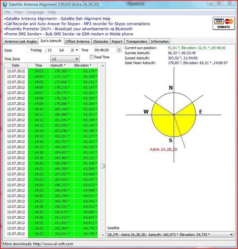
Suns Azimuth tab (usefull to set your "due South") Satellite Antenna Alignment (Satellite Dish Alignment) Will tell the local time of sun position at XXX (180° or close to it for due south, geographic not magnetic is used ) Can be used to mark pole every XX degrees for a reference.
I've always used inclinometers as sometimes I don't trust the scales on some dish mounts.
A receiver with Blind scan is a must today for the ever changing active transponders. Don't know what I'd do without it.
wonderfull signal from the Astra 1D/2D - - Congratulations!

Thanks, Slowly it is coming together, a light at the end of the tunnel (cable) as it were. I had wondered what the suns azimuth tables could do to help, This is typical, it hasnt rained for months and today when I want the sun it is raining and could rain for the next 3 or 4 days.
As of todays table if I scroll down to the times nearest to 180° (14:09 - 14:10) pointing my dish into the sun and pressumable I can line it up with the shadow centralised with the lnb in the middle of the dish. Am I reading that correctly.

I will experiment with a couple of other sats by just swinging it round after I have located and marked the pole due south and fixed a degree scale on the pole eg.
BUT the big problem will be setting up the polar mount when I have made it. Thanks again for your expert advise.


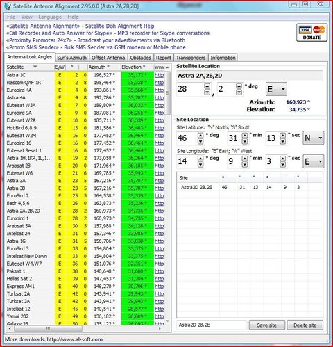
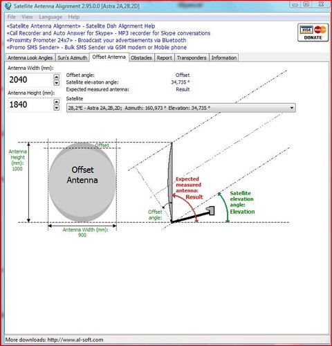
Astra 2A,2B,2D LookUpAngles.JPGAstra 2A,2B,2D Offset Antenna.JPGAstra 2A,2B,2D SunAzim.JPG
 
I reading that correctly.
Yep! And if a satellite is not at zenith, find it's azimuth, then refer to the sun azimuth table for the time the azimuth is closest. align dish to the sun at that time. Bingo.
Although the sun is above the satellite during summer months, the suns shadow won't appear on the dish itself, only on the lower support arm.
 
PICT3226 - Kopie.JPG (127.0 KB)

It couldnt be that easy as I said but the idea was on the right track. By the lower support arm will that cast a shadow? Now when you say 'if a satellite is not at zenith, find it's azimuth' Is this the azimuth that is on the Satelite Antenna Alighnment table eg Astra 2A/2B/2C which is 160.973° Then I look at the azimuth of the sun table see which time the sun is at that azimuth, then point my dish at the sun?

One more thing you said 'a blind scan is a must' Can every receiver do a blind scan or is it just the more modern ones? My main stb is a spiderbox 9000HD which also picks up very weak signals from 28.2° astra 2, and other friends around cannot receive ITV and BBc channels from england with a 90cm dish. I know a receiver plays a big part in the quality
of the signal as I surprisingly found out.

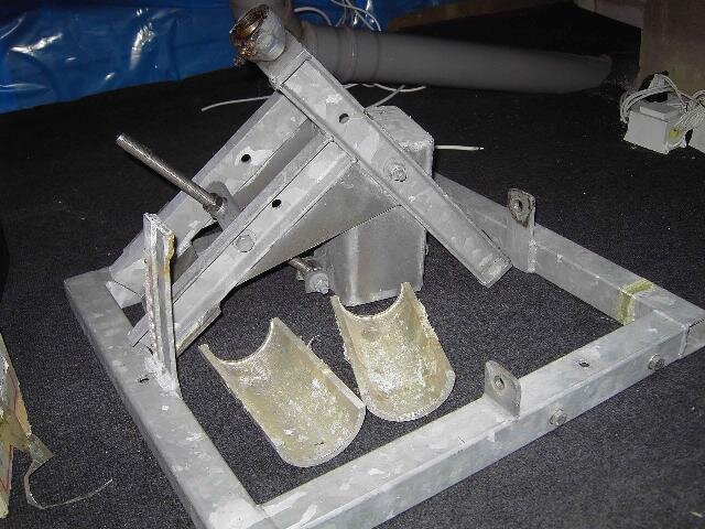
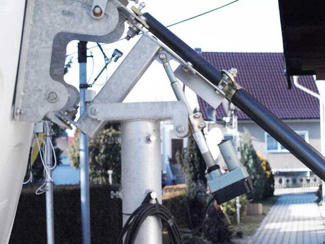
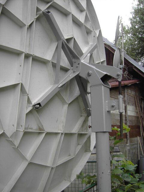
I have added a couple of pics of polarmounts i have found and mine as well, i am sure I canalter my to suit using some parts as the dish fixing,the pole mount and the threaded adjuster can be adapted. When I have something construction, a new can of worms will be opened.


polarksufvp9myx2.jpgPolarmountDXTV.jpg
 

Attachments

  • PICT3226 - Kopie.JPG
    PICT3226 - Kopie.JPG
    110.1 KB · Views: 249
Last edited:
then point my dish at the sun? Absolutely correct. The LNBF will cast it's shadow on the lower support arm.
>>Can every receiver do a blind scan or is it just the more modern ones?<< All the newer ones usually* have Blind Scan. Some may call it Advanced Scan or something similar. (Blind Scan will find and log all active transponders on a satellite)
here's some others polar mounted offset projects for guidance or inspiration:
http://www.satelliteguys.us/free-air-fta-discussion/171838-prodelin-1-2-offset-polar-mount.html
http://www.satelliteguys.us/free-air-fta-discussion/185600-1-2m-primestar-dish-polar-mount.html
http://www.satelliteguys.us/free-air-fta-discussion/263243-stogie5150s-prodelin-project.html (latest)
*I'm aware of one model that doesn't have it. It's a AzBox model(name escapes me)
Power Scan is what the Spiderbox calls Blind Scan.
 
Last edited:
Hello FTA, I did write further last night but I must of missed the enter as its not there anymore.
I will just write the jist as I wrote quite a lot.
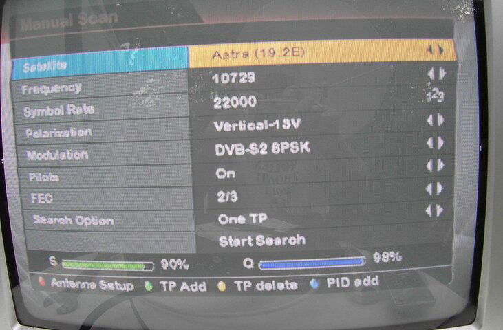
When I connected my spiderbox by the dish, instead of 28.2 Astra it was 19.2 astra,. the old box is for nothing.
Didnt catch the sun at due south, so using 19.2 as datum point. I measured the circ. of my pole 286mm. so to move 9° more eastwards I needed to swing the dish 7.15mm east to get 28.2.
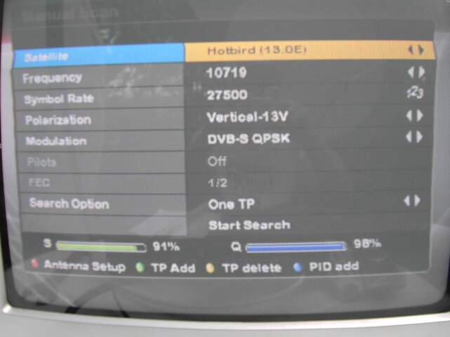
I couldnt get a signal so tried some others, some came (all reading 98%) but some I couldnt get.
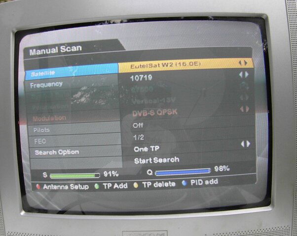
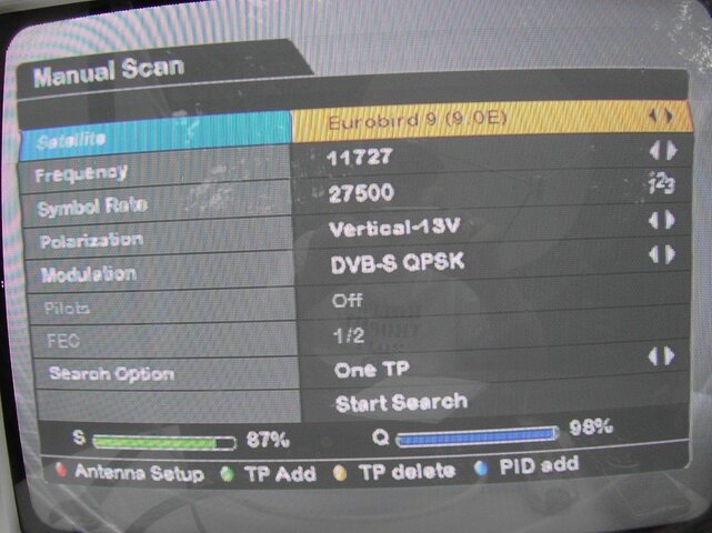
I then thought this is the arc that is why a polar mount must be used but I saw one anomally which was eurobird9 which I also had a 98%. Here is a list of the sats I experimented with before it rained again.

Astra 1D 28.2° El. 34.735° Also Eurobird 1 same figures.
Astra 1 19.2° 36.264°
EutelSatW2 16.0° 36.464°
Hotbird 13.0° 36.483°

EutelSatW1 10.0° 36.339°
Eurobird 9 9.0° 36.255°
EutelSatW3 7.0° 36.032°

If the arc of the satellites is the explanation then why could i get eurobird9 but not eutelsatW1?

PICT3393.JPGPICT3400.JPGPICT3404.JPGPICT3405.JPG
I looked at all your links and thinks I will have some problems like it appears many do trying to make their own supports, especiall using a mole grip wrench!
I did also read that if you do everything in the correct order correct is is no problem. THis is why it is important to visualize the curvature of the arc which I assume is the same as the curvature of the earths surface.
Im not the youngest and so long away from school and geometry, I was hatched in 1941 eldest of 10 kids.
Have a nice Sunday, here we have had torrential rain Thunder storm all night but the earth needed it.
Bye for now.
 
More beginner's questions

I bought one too! I'm going to start putting it together soon. Thanks for all the information and pictures that have been posted. I will benefit from all the experience you pioneers have accumulated. But knowing me I will still probably run into a few problems. I hope you all don't mind if I ask more questions when I do. I know practically nothing about any of this and already have a couple of questions. Will the inexpensive LNBs I can get on ebay work? Do I need to get an 18' or a 24 inch actuator ? And what is an S2 signal?
 
>>using a mole grip wrench<< I think [hope] that they were only used during mock-up, proving the theory before bolting/welding it all together.

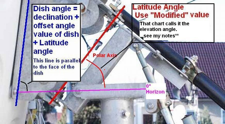
I threw together a picture to hopefully explain the angles involving an offset dish on a polar mount. See Attached:
Example (Angles measured at 'due south") :
Location is 47° North. Offset angle of dish = 24°
From the chart* the Elevation angle** (modified polar axis angle) is 47.65°
The Declination offset angle from chart" is 6.38°
Dish face = 24° + 6.38° + 47.65 = 78.03°
Testing/Confirmation: offset dishes "look" offset degrees up from the perpendicular of the face of the dish.
90 - 78.03 + 24 = 35.97°
Dishpointer.com says the satellite arc elevation at "Due south" with location at 47N is = Elevation: 36.0°
36 and 35.97 is close enough to = for me.

* Footprints by Dish Size - Latitude Declination Chart - C/Ku-Band Satellite Listing
** I don't like calling it the "Elevation" as it's easily confused with the elevation of the satellite.

JeremielMontanez, :welcome to the forum.
>>Will the inexpensive LNBs I can get on ebay work?<<At the moment, that is all I am using on Ku band. (Standard Ku LNBF with a L.O. of 10750 Mhz) but then again, I'm not 'In Search Of' every signal out there. You may consider a Universal (L.O. 9750 & 10600) for a few satellites out over the Pacific(?) being as far east as you are.
>>Do I need to get an 18' or a 24 inch actuator ? << Depends on the dish. Now we're talking Cband, prime focus, dish, right? OK, (re-read post) you got a 6ft solid/panelized? I would not try dual band 'out of the gate' as the dual band (C and Ku) LNBF's are a trade-off, performance wise. And a 6ft prime focus is not optimum for C band. And the Aiming for Ku with it is critical. It's 'beamwidth gets quite narrow at Ku, while C band is wider than the present satellite spacing. Chances of adjacent satellites interfering on C band is possible. Look up the beam-width of prime focus dishes vs. C and Ku band.
For C band, I like my Satellite AV C2 LNBF. (L.O. 5750 Mhz.)
>>And what is an S2 signal?<< Digital Video Broadcast -Satellite Second Generation =DVB-S2
The first generation was just DVB-S (Digital Video Broadcast - Satellite) S2 packs more information into equal bandwidth.
Many broadcasters are switching to S2 to put more, in less bandwidth, on the satellites. Saves them money, kinda like higher mpg.
Spend some time reading threads and If something 'doesn't make sense' start a thread and you'll get it answered/cleared up in no time.
Welcome to the affliction, eh, addiction, oh!, hobby!
 

Attachments

  • PolarmountDXTV.jpg
    PolarmountDXTV.jpg
    76 KB · Views: 224
Thanks again FTA, Your explanation is perfect, I had already printed out the link you attached ''Footprints by Dish Size - Latitude Declination Chart - C/Ku-Band Satellite Listing''
From the same site I had already printed out the 17 pages of "Adjusting the polarMount3/3" this I keep reading and finding something each time that I understand better.
I downloaded a free app called 'Satellite AR' now standing in front of my dish I can see the locations, really fantastic. BUT on this app it calls THOR II and THOR III but on my stb and google there are Thor 2/3 which also refers to Amos 2/3, Thor 3 at 4°W and Thor 5/6 at 0.8W this is an interesting one for me but it looks like I will have to drastically prune a damson tree. Are these two definitions Thor II and III the same two?
Good weather is again with us so I have lots to experiment with and tomorrow I am off getting some steel for the new polarmount.

I couldnt follow.....
"Dishpointer.com says the satellite arc elevation at "Due south" with location at 47N is = Elevation: 36.0°
36 and 35.97 is close enough to = for me."
Maybe its because i didnt enter a satellite as you didnt stipulate one, opening dishpointer.com I could enter 47° instead of 'potters bar' which it opened at. Am I on the right line.

I see Dishpointer.com also sat apps for mobiles but there are 19 USD.
Thanks for your effort and patience.
 
It doesn't matter your Longitude. The arcs highest point is determined by the site latitude.
The satellite arc, if you're standing on the equator, goes from due west to due east passing directly overhead. If you're N or S of the equator, say at 47° N, the arc is from the SSW to the SSE, (47° S would be from NNW to NNE) with the the arc's highest point directly south (North) of you.
sat%20arc%20271.jpg

That height is determined by how far North (or South) of the equator your location is.
At the N or S pole, the 'arc' would be all around you at the horizon.
 
Ah so, experience big dish and aim it too. Combination of all is that: with the right declination, and elevation; applied to a dish; with true south as to the aiming of the mounting apparatus; allows all satellites from "you are just a spot on the map" to be programmed and received. That is what it is designed to do, and what it does, too. Good luck!
 
Ok. So I am at 46°31'13" so I can also say 47° is that so. Its is important that I get the basics right. I will now consentate on makeing the polar mount and no doubt I will be looking for help in the future. Zhanks for all the information. Pity you dont live a little nearer or better still just around the corner.
I will be in touch. Colin
 
I'd use 46.5188 (or what ever the min,sec converts to in decimal.) as a half a degree could degrade your results. ( .5188 came out of my head) Google maps, locate your site, right click on the dish position, select "What's Here". Look in that pages location text area. Use those numbers for your latitude. It's worked for me. Good luck.
 
Hello FTA, hope you see this.
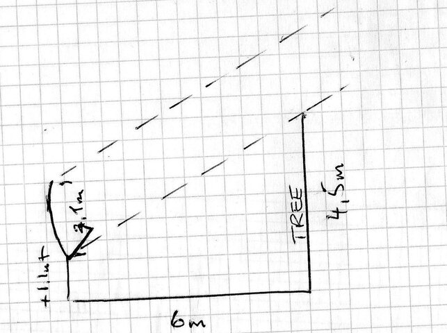
I am having a problem getting a fix on the Thor 5/6 at 0.8w, as I said earlier I probably must drastically prune a damson tree, well I have lopped it down to 4.5m height. It is 6m from my dish. The bottom of my dish is 1.1mt with the top being another 2.1mt higher. I have looked on the Sat anntenne allignment table for Thor and cannot get the correct distances in but have 5m fot the tree and 5m away from the dish. This gives an angle of 45°, but where on the dish is the base line where the distance from the tree hits the dish.
Obviously if the dish is higher it will pick the signal up but how high must I lift the dish. This is why I havnt started the polar mount as I will have to alter something.
See my sketch maybe this will be clearer.

img001.jpg
 
The bottom of the dish will be the first area shaded by an obstacle.
Bottom of dish 1.1M from ground.
Make 'baseline' the same height on tree, 1.1 meter from ground.
Find Tangent of satellite elevation. dishpointer.com** ( I used 34°)
Multiply Tangent of elevation angle by baseline distance (bottom of dish to obstacle/tree)
Result is allowed height above the baseline.
Overall height = result + height of baseline above ground (1.1)
**According to dishpointer.com
Location
Latitude: 46.5000°
Longitude: 14.1794°
Thor 5/6 is at
Dish Elevation: 34.5°
Azimuth: 200.2°
My math: 34° sat elevation, 5 meter baseline distance to obstacle.
Tan(34°) = .6745
.6745 x 5 = 3.3725
Overall tree height without shading dish
3.3725 + 1.1 = 4.4725 M (From ground-if ground is level)
(BTW, what's correct to label a number in meters, M or m?
4.5 meter tall tree will just shade the bottom 0.0275 meters of the dish.
(about an inch)
 
Thanks again, I will raise the dish maybe a meter as wifey wont let me prune more off the tree. I could find another place but would be inconvienience.
So I will lift to start with. Does the signal come in over the whole area of the dish, I thought it was just a beam hitting a point and then reflecting to the lnb.
So what about the width of the dish, is that liable to shadow/obstruction as well.
Thanks. I have copied everything down.
 
The dish itself is a 'lens' that focuses at the feed. So yes, any of it's surface that's shaded from the satellite is lost signal.
Trees start at the ground and grow up. dishes collect signal from the bottom to the top. reason to use the bottom of dish and top of tree/obstruction in the calculations.
Sometimes the top of the dish has to be used as the reference. I've had to relocate some subscription(pizza) dishes that were located under and too close to an overhanging roof.
(Tucked up neatly for looks, but no good for performance)
 
Thanks again, have taken the chainsaw to prune the tree again, thats the easiest and the wifes out. Took about 0.6m off. (60cm)
Missed your M or m on line. smalll m is used. (6m.) same as (600cm.)
Dont know why decimalisation didnt take of in the states, england also use mostly feet and inches.
Will let you know it will probably be tomorrow before I get set up again. Olympics and all that.
 
Thank our 'authorities', I guess. Just about anything mechanical over here is 50% SAE and 50% metric. So to work on anything now requires two toolboxes. One "American" and the other metric. We also have ATSC while most of the rest of the world adopted DVB-T, GO figure???
 
Status
Please reply by conversation.

Users Who Are Viewing This Thread (Total: 0, Members: 0, Guests: 0)

Who Read This Thread (Total Members: 1)