T90 Limitations

Status
Please reply by conversation.
I don't recall this being the experience of Iceberg when he set his T90 up.

How much weaker of a signal?

Don't the outboard LNBF's help get the skew of the dish just right?

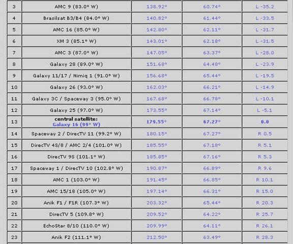
I have no issues with the outside LNB's. Mine were 72 & 111.1
72 had the same or better numbers than my 30" motorized and 111.1 was for the Starchoice system and registered good numbers
 
So, each LNBF needs to be skewed just as if it were a stationary dish?

The Sat Lex site didn't mention skewing each LNBF. Is there a website that tells you how much skew you need in each one per your location?

I suppose this could also interfere with how close you can get the LNBF to each other.

you skew (twist) the LNB holder so that it hits the reflectors properly.

You can skew the LNB too for optimum signal. But normally it stays at zero
 
I don't recall this being the experience of Iceberg when he set his T90 up.

How much weaker of a signal?

Maybe Iceberg has a better location, or satellite signals naturally radiate to him, but for "me" the outboard LNB's signal is much weaker. Not better then 70% of the center LNB. Not that the signal meter on the receiver will show, but measured with a satellite signal meter at the dish. Even the weak satellites give good signal numbers in applications like MyTheatre for some reason. My guess would be that the Toroidal design cuts down on background radiation which a normal dish would reflect into the LNB.

The statement that all the LNB's have the same signal strength on a T90 is bull to me. (I have two!)

Don't the outboard LNBF's help get the skew of the dish just right?

Yes, the dish is skewed for best signal strength of the two outer most LNBs.
 
that site has never been very acurate for me.. it's generally very far off.. calcs aren't 100% .. the company provides much better details.. though I've gotten to the point where I can align it fairly well now with just a little luck and patience.. :)
 
Errors when E to W or W to E of your longitude.

Aside from the rail positions being off, is there anything accurate about the Satlex calculator? I've never used it before.

Hi everyone,
I've been helping members of our forum to set up their WF toroidals.
What has become obvious, is the inability of the Satlex calculator to give realistic figures when your longitude is amongst that of the Sats. In other words, you have Sats to the E and W of your location and your view of the Clarke Belt parabola peak is more or less due North from Australia. I think the same would apply looking South from the US.
Have others encountered this and what is the fix.
I can only suggest interpolating a mirror image figures from the one side to the other.
Kindest Regards, " The Druid ".....:eureka
 
I don't have a t-90 but I was running some numbers from my location (48.4N) and it says I could get from a 44 degree arc when it is centered close to true south, and up to about 48 degree arc when centered farther east or west.
Then I ran some for Edmonton AB (53.5N) and got a range or arc from 48 to 52 degrees with 48 being true south. Then Mexico City (19.4N) get only about 22 degrees centered TS to 55 degrees centered farther east.
All sats showed between + and - 25 on the guide bar.
Definitely seems to be related to how far you are from the equator.
 
G'Day,
I've been giving this a lot more thought, and my conclusion is:

I've attached a "satlex" output near enough for Mexico City.
All this proves is that the WaveFrontier Toroidals can only be successfully used on one side or the other of the Clarke Belt, but not across the top.
If you look at the elevation figures, you will see that they decrease either side of the central Sat. This is consistent with the Clarke Belt, but cannot be achieved by tilting the dish to change the elevation.
I postulate that the claims, cannot be achieved in practice.
I've given this quite a lot of thought and searched the web, and this is the only feasible argument to explain the inconsistencies.
Thank you for your input and interest,
Kindest Regards, " The Druid ".....:eureka
 

Attachments

  • TorMex_1.jpg
    TorMex_1.jpg
    67.3 KB · Views: 176
I've attached a "satlex" output near enough for Mexico City.
All this proves is that the WaveFrontier Toroidals can only be successfully used on one side or the other of the Clarke Belt, but not across the top.
If you look at the elevation figures, you will see that they decrease either side of the central Sat. This is consistent with the Clarke Belt, but cannot be achieved by tilting the dish to change the elevation.
I postulate that the claims, cannot be achieved in practice.
I've given this quite a lot of thought and searched the web, and this is the only feasible argument to explain the inconsistencies.
Thank you for your input and interest,
Kindest Regards, " The Druid ".....:eureka

wanna bet?

I had both sides of the clarke belt on my T90 with no issues. I went from 72-111 (even 119) with my T90 and I am in Minneapolis, MN (true south 93W also my centre LNB). You can tilt the dish to get both sides of the belt no matter what the elevation is. Plenty of folks have used the T90 with oddball elevations. Oddball meaning their centre LNB has a skew already.

Here is my review of the T90

http://www.satelliteguys.us/fta-mpe...ve-frontier-toroidal-t-90-satellite-dish.html
 
Follow the Clarke Belt.

G'Day Cobber,
First up, I don't doubt that you have your dish up and running.
I've attached the relevant parts of the two lots of your data.
In the first you are only 10 degrees off due South for your central Sat.
This means you only have about 2 degree error in elevation at the 83 end from your central Sat.

The other one where you cover 72 to 119, would give an error in elevation of 8 degrees from your central Sat.
This reinforces my contention that you cannot get optimum across the top of the Clarke Belt and why many are having problems setting them up.
As far as your setup is concerned, "If it ain't broke, don't fix it."
Many thanks for your replies,
Kindest Regards, " The Druid " aka Bill....:cool:
 

Attachments

  • TorMinneap_1.jpg
    TorMinneap_1.jpg
    79.7 KB · Views: 140
  • TorMinneap_2.jpg
    TorMinneap_2.jpg
    79.1 KB · Views: 156
I haven't ever had any problems with my T90. I've had everything from 82W through 129W, which is 47 degrees of arc. When doing so I had about as much signal as I have had with a 100cm dish with one LNB on it.

Admittedly, I've spent a lot of time getting it to that point. My experience is that the Satlex calculator is definately not accurate. In fact, I found that dishpointer.com or kusat.com are much better. All I do with those is pick multiple sats, take the info the site spits out and set the T90 to that. Worked every time.
 
In the first you are only 10 degrees off due South for your central Sat.
This means you only have about 2 degree error in elevation at the 83 end from your central Sat.
actually my venter sat IS my true south. Here in the US from 111 to 123 is a wasteland on KU so I have 123 on a separate dish. Actually 105 is the end of KU for a while (107,110,111 are subscription satellites)

The other one where you cover 72 to 119, would give an error in elevation of 8 degrees from your central Sat.
nope. Kept the setup as is. I added a piece of wood to extend the bar to get 119 which is a subscription satellite here (but NASA is FTA)

This reinforces my contention that you cannot get optimum across the top of the Clarke Belt and why many are having problems setting them up.

Most of us dont have issues. I think part of it is this 5 month old thread was dug up so alot of the posts at the beginning may not be relavent anymore ;)
 
Satlex program errors.

G'Day Cobbers,
Thanks to your input, it has become increasingly obvious that the error is in the program when looking from the South. When I change the view to looking to the South with the same Sats and longitude, the figures appear realistic.
As a matter of interest I attach the relevant charts.
Again, many thanks for helping me solve this problem.
Kindest Regards, " The Druid ", aka Bill. :)
 

Attachments

  • AusNthLook_1.jpg
    AusNthLook_1.jpg
    61.8 KB · Views: 170
  • AusSthLook_1.jpg
    AusSthLook_1.jpg
    62.3 KB · Views: 162
weird.....but now ya got it figured out :)

by the way...off topic....

how many satellites can you get programming off of in Australia?
 
Status
Please reply by conversation.
***

Users Who Are Viewing This Thread (Total: 1, Members: 0, Guests: 1)

Who Read This Thread (Total Members: 1)