First Signal

  • WELCOME TO THE NEW SERVER!

    If you are seeing this you are on our new server WELCOME HOME!

    While the new server is online Scott is still working on the backend including the cachine. But the site is usable while the work is being completes!

    Thank you for your patience and again WELCOME HOME!

    CLICK THE X IN THE TOP RIGHT CORNER OF THE BOX TO DISMISS THIS MESSAGE
Status
Please reply by conversation.
The LNB is 100% stable btw. I can rotate it for skew if I put a lot of muscle power into it, but otherwise its aiming directly toward the dish
 
Did you assemble the post clamp in the butterfly bracket with the through-bolt going through the hole stamped "A"?

If so, looking at the scale "A", the pointer is a flat price of metal (originally painted white), visible on the left side of the elevation nut, it should be pointed to approximately 54 degrees.

The LNBF skew in the photo looks right for your area on 97w satellite.

Placing your phone on the metal dish will cause the compass to be inaccurate. Stand a few feet behind the dish and find a landmark like a tree, utility pole, etc. that is far away that lines up with compass reading 178.

Now review post #2 of this thread for how to setup the receiver and aim the dish.

Good luck!
 
Alright! so, it's assembled just like you say. When it's at 54 degrees on scale A, it looks very very low, there are other satellite dishes on my neighbors homes and they are aiming much higher than mine is. It's like aiming towards the fence. Is this to be expected with this type of dish?
 
I can tell you, from installing satellite systems for almost 14 years, that having a good, stable, and plumb mount are the keys to getting a satellite dish aimed easily and correctly. I recently aimed my first GEOSATPro 36", which looks like what you have. The elevation was a little hard to determine on mine, because the white mark they referenced in the documentation, was obscured by the nut on the elevation adjustment. I figured out it's roughly the metal edge you can see through the elevation adjustment slot. Anyway, point is, don't skimp on the mount, make sure it's plumb, cement it in, as long as you have good LOS (Line Of Sight) you should be able to tune it in. I'm not familiar with your receiver, but mine showed no signal or quality until I ran a Blind Scan. Ku FSS signals are pretty weak, so it takes a bit of fine tuning to get decent signals on them.

All that said, I'm very new to this, and this is just my advice as a Dish/DirecTV/HughesNet installer.

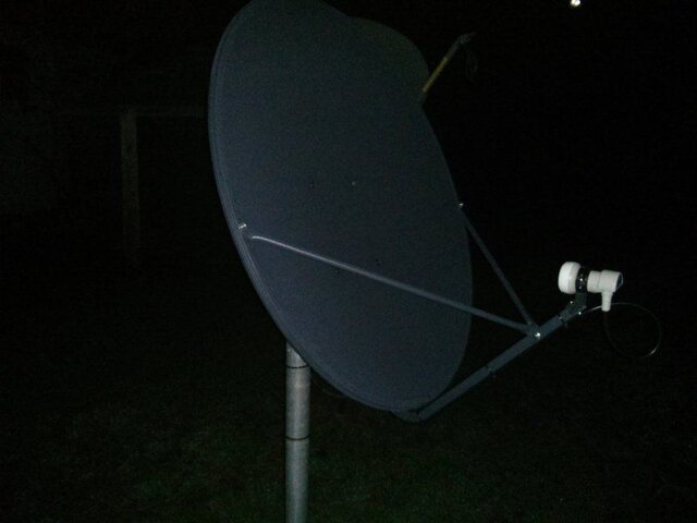
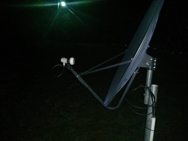
Here are some pictures of mine, these are bolt hole A, about 50 degrees elevation on scale A, just to give you a reference. My LNB is also only -2 degrees for polarity, so pretty much straight up.
 

Attachments

  • IMG_20171011_001812.jpg
    IMG_20171011_001812.jpg
    33.2 KB · Views: 140
  • IMG_20171011_001855.jpg
    IMG_20171011_001855.jpg
    40.3 KB · Views: 117
  • Like
Reactions: danristheman
Your dish looks exactly like mine at 50 degrees. I guess it's correctly set up!
(Question: Do HughesNet dishes transmit? Is that why they want the LNB back?)
 
Mine works, it's aimed at Galaxy 19, 97 West, and I'm in southeastern Oklahoma. G19 is 184 degrees azimuth, 50 degrees elevation, and -2 degrees on the LNB, if I remember correctly, for my location. Those pictures show the dish aimed at 97 West from where I am located.

HughesNet 6000 and 7000 series were Ku Band FSS (As far as I know.) and both transmitted and received. Some older systems before those only received via satellite and transmitted via a dial-up connection. All the newer 9000, Gen4, and Gen5 systems are Ka Band, and they also transmit and receive from the satellite. The LNB is called a radio, since it both transmits and receives, and HughesNet usually wants it back so they can test/refurbish it and use it as a replacement part for defective radios.
 
  • Like
Reactions: soundman65
Very interesting. Same satellite 97 here, in SE Texas. Wow, I thought for uplink you'd need like a big 20 foot dish with special equipment! Here, it's 181 azimuth, 54.4 elevation, 1.2 degrees skew.
 
I have an adult friend that tried at this, he had bought the equip off eBay. After getting bored with it, he then decided to recycle everything and put the dish at the curb. I freaked out when I saw a GSP on the curb, so I hauled it home. Me and him were already friends so I asked why he was chucking it out. He said he doesn't need it, he has found OTA TV to be enough and easier. He said he has a few boxes for it, and a motor. Very awesome!!! Got a Skybox, X2 Premium (which I chose as main), two extra lnbs, and a tester (which I lend to a friend, don't have right now). I gave him a few computers for Linux, I did not feel OK not giving anything in return.
 
Very interesting. Same satellite 97 here, in SE Texas. Wow, I thought for uplink you'd need like a big 20 foot dish with special equipment! Here, it's 181 azimuth, 54.4 elevation, 1.2 degrees skew.

Nope, I think all the HughesNet's were the 0.74 Meter dish. It just had to be mounted a certain distance above ground because it transmitted and they didn't want people getting in front of it. (RF Radiation Danger) During the pointing procedure it would only turn on the transmitter once you had locked on to a satellite/transponder it recognized as acceptable.

Anyway, I hope you get your FTA system aimed, a meter would be helpful, but I understand you're on a tight budget. Run the blind scan as suggested if you think you might have it.
 
The dish has a 24.62 offset angle. This means that the dish is actually aimed 24.62 degrees higher than the dish face angle. When the face of your dish is angled back approximately 30 degrees, it is picking up satellite signals from 54.62 degrees elevation.

If you look at dishpointer.com for the 97w aiming from your location, the magnetic compass reading is 178. This is only a few degrees East of 181, but be sure to use the magnetic reading when using a compass. You can also drag the pointer to the exact point on your property where the dish is installed to provide an aiming line to the satellite as a overlay on Google maps.

You won't be able to point the dish at 54.4 degree elevation and rotating the dish to the 178 degree compass reading and expect to be receiving satellite signals when you walk inside the house. The aiming is very precise and a fraction of a degree in elevation or azimuth and the signal will not be received. Set-up the receiver and a small TV outside beside the dish to watch the Signal Quality meter reading to locate and optimize the dish aiming.

The pounded in pole could work for testing. You might get away with a pole pounded in the ground until the first rain or wind, but it will move unless it is set in a few bags of cement with a bolt through the post or the post flattened near the base within the cement, to prevent it from spinning.
 
Thank you everyone - 99W comes in good! I never would've got this without 1. your help and 2. had I not figured out the little white elevation thing. The receiver beeped and said "LOCKED - 67 dB". Very interesting stuff - it's amazing how funnily bad the motion graphics are on some of the channels xD
 
Glad to hear you got it!!
 
It records too! Also on QVC they're selling these coconut chocolate cashews for $46 for a 16 oz can. Must be a fine luxury food. Thousands have sold apparently! lol!
 
Status
Please reply by conversation.

Users Who Are Viewing This Thread (Total: 0, Members: 0, Guests: 0)

Who Read This Thread (Total Members: 2)

Latest posts