
Why declination is needed in H2H motors?
- Thread starter enb141
- Start date
- Latest activity Latest activity:
- Replies 23
- Views 4K
You are using an out of date browser. It may not display this or other websites correctly.
You should upgrade or use an alternative browser.
You should upgrade or use an alternative browser.
- Status
- Please reply by conversation.
I'm wondering why declination is also needed with H2H motors for offset dishes?
Declination changes with location, so it's necessary to have that adjustable.
Enb,
Realize that there are two different notions regarding DECLINATION.
One relates to your site's latitude and affects your dish elevation (but not your motor latitude setting). The further north or south you are from the equatorial plane, the more you must tilt the dish elevation to a lower angle to view the satellite. If you are directly on the equatorial plane, your dish is essentially pointing straight up at the satellite. This should be relatively simple to comprehend.
The other declination angle, which is a bit more illusive, deals with the magnetic lines which surround the earth and which you rely upon a magnetic compass to show you some depiction of north, south east or west direction. These magnetic lines are not laid out in a nice "square" grid like the latitude and longitude coordinates on the globe. They do not conform to straight line coordinates and vary considerably from location to location. Here the problem and the confusion arise because true north and magnetic north are not the same place. Not only this, but the magnetic pole moves over the years and the magnetic lines are not straight lines.
Therefore, they have come up with compensations for a magnetic compass, referred to as magnetic declination. If you know where you are and you know the magnetic declination at that location, you can "CORRECT" your compass so that you know where TRUE north is as opposed to magnetic north.
You might have to add 3, 7 or 12 degrees or subtract that much from it to obtain the true north direction.
Satellites are lined up according to TRUE north opposed to magnetic north, but the most common manner to locate the sat position is via a MAGNETIC compass, which does not always point to the TRUE NORTH.
Therefore, if the magnetic deviation is +5, +3, -6, -2, +12 or -7 degrees, you have to add or subtract that many degrees from what your magnetic compass shows in order to aim the dish in the proper direction.
Along the Mississippi River basin, this angle of declination is virtually zero degrees. This is considered or referred to as an ISOGONIC line. Meaning that the true north and the magnetic north "appear" to be at the same location on the globe.
To the east of this line, you must ADD the declination angle to the geographic position to obtain the magnetic reading on the compass.
Some online calculators will provide you with both the magnetic and the true geographic headings.
RADAR
H2H means the drive can move the dish roughly 180 degrees. Some of the old polar mount BUDs could only do 120-140. For the rest look here Footprints by Dish Size - Latitude Declination Chart - C/Ku-Band Satellite Listing
no, no, no!
/soap box mode=on
No, let's not confuse the issue with "magnetic declination"
Use any other term, please.
Magnetic correction.
Magnetic deviation.
Magnetic offset.
Magnetic error.
And just say "no" to anyone ... regardless of their intentions, and regardless of what they quote, who uses the term: magnetic declination.
In the context of satellite dish aiming, one kind of declination is enough.
If you are a surveyor, or a geologist, or anything but a dish-guy, I don't care what you call it.
But here... well... let's follow the KISS principle.
Thank you.
/soap box mode=off
PLEASE LOG IN TO GET RID OF THESE ADS!
Right, and other than if you are at the equator, you need declination to calculate the down-tilt correction necessary to "see" a satellite orbiting the earth at such a close distance.Declination changes with location, so it's necessary to have that adjustable.
If you were looking off 100 light years into space, declination would be inconsequential.
So, all motors controlling dishes looking at any object as close as a satellite, will require declination.
See good picture and description at the top of this page on Geo-Orbit.
/soap box mode=on
No, let's not confuse the issue with "magnetic declination"
Use any other term, please.
Magnetic correction.
Magnetic deviation.
Magnetic offset.
Magnetic error.
And just say "no" to anyone ... regardless of their intentions, and regardless of what they quote, who uses the term: magnetic declination.
In the context of satellite dish aiming, one kind of declination is enough.
If you are a surveyor, or a geologist, or anything but a dish-guy, I don't care what you call it.
But here... well... let's follow the KISS principle.
Thank you.
/soap box mode=off
Anole,
If you are referring to my post specifically, I apologize for bringing up the information of magnetic declination. However, if anyone is going to "Google" or otherwise search for this term and help with the definitions, they are going to run into this eventually.
I strongly believe that it needs to be explained up front so that they understand the information that they will find along the way. Otherwise they may be left on a search result explaining one or the other and scratching their heads and exclaiming "What?".

I don't use a compass to determine my directions at my residence because the magnetic fields are so screwed up here by some unknown anomaly. I therefore use GPS (or satellite images from Google Earth) to determine my true azimuth settings "in a rough sense" and then fine tune the dish to the signal itself.
To explain declination in a more obvious sense, go hunting deer with your rifle. If you sit in the tree stand or at the base of the tree, you obviously have to alter the elevation of the gun to hit the desired target. The target did not move, but your earthly elevation did. So hunting one particular satellite is nearly identical. If you live in North Dakota versus south Texas, you have to readjust your aim to hit the intended target just the same.
RADAR
Last edited:
Ok so after reading what you have posted that means that if I use a GPS or I add the magnetic correction so I don't need declination right?
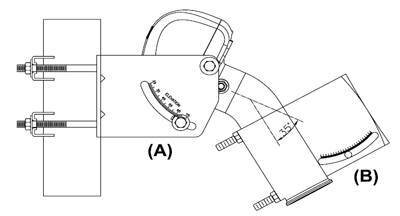
Here is the declination that I'm talking about (b)
Enb,
No, Anole was right. I confused you. Sorry.
The declination angle that you are referring to is in regards to the curvature of the earth, looking towards the equator from a northern lattitude. If you live at a far north latitude, you need to tip the dish reflector down lower to hit the satellite. The further south you move, the higher you need to point the dish.
The motor latitude setting is always set to the site latitude.
That was the first item that I addressed in my original post. Don't worry about the magnetic declination angle (also referred to as the magnetic deviation angle). That deals with the east to west alignment of the dish and motor, not the up and down tilt of the dish.
RADAR
Last edited:
Enb,
Your picture is going to be a tad bit misleading as it shows "ELEVATION" on the motor bracket. Ignore that and look at the opposite side of the motor bracket. It should show "LATITUDE".
Determine your site's latitude and set the motor "LATITUDE" to that degree.
The "ELEVATION" scale in your picture should then show an angle setting of [90 degrees minus the site "LATTITUDE"]. Meaning that the two scales will NOT read the same angle, unless you reside at 45 degrees latitude. i.e. 90 - LAT = ELEV hence: 90 - 45 = 45.
Next, you need to set the dish "ELEVATION" appropriately. This angle is determined from the physical geometry of the dish mounting bracket and the angle of the motor tube. This angle should be explained in the instructions for installing the dish itself.
For now, ignore the magnetic declination angle. That does not come into play with what you are setting up here.
RADAR
PLEASE LOG IN TO GET RID OF THESE ADS!
Ok so if I'm in latitud 14-15 and longitude 90-91 dishpointer said 72.9° but in the table from the manual it is 77-76 and declination 2.3-2.4 what should I believe?
Enb,
Please do notice the angle of the motor tube in the picture that you provided. In your picture, it is 35 degrees. Not all motor tubes are of the same angle. Some are 30 degrees, most are 35 degrees and some can be 40 or possibly 45 degrees.
This will alter the degree that you must set the dish bracket elevation. Refer to the motor and the dish assembly mounting hardware instructions to determine the dish elevation properly according to your motor tube angle.
If you purchase a complete package (dish, motor and receiver all made by the same company), you won't have any doubts about these angles as they will explain it all properly in their install manual.
RADAR
Ok so if I'm in latitud 14-15 and longitude 90-91 dishpointer said 72.9° but in the table from the manual it is 77-76 and declination 2.3-2.4 what should I believe?
Enb,
Try this calculator: Satellite look-angle calculator and enter your EXACT lat and long coordinates - and motor type.
Let us know what this calculator tells you.
RADAR
Enb,
Wow! You are really far south from me. I never looked to see your location, but at 14-15 degrees latitude, you are dang near the equatorial line.
Your dish and motor are going to be pointed very HIGH compared to my setup.
By the way, are you at a North latitude or a South latitude? Can you provide your exact longitude and latitude coordinates? You don't have to offer this, we can determine your settings for the motor and dish in a rough sense without being accurate to the degree.
This is really excellent though. Enb, I have not conversed with someone who resided that near the equator, so I am very interested in your settings / setup.
RADAR
Hey the link you gave me said this:
Can't calculate for your location, this calculator is for the North Western hemisphere only!
My data is this:
Latitude: +14.6248°
Longitude: -90.5328°
Guatemala city.
Can't calculate for your location, this calculator is for the North Western hemisphere only!
My data is this:
Latitude: +14.6248°
Longitude: -90.5328°
Guatemala city.
PLEASE LOG IN TO GET RID OF THESE ADS!
Hey the link you gave me said this:
Can't calculate for your location, this calculator is for the North Western hemisphere only!
My data is this:
Latitude: +14.6248°
Longitude: -90.5328°
Guatemala city.
Enb,
That calculator does require you to enter (check-off) certain selections and enter the coordinates in a specific format otherwise it gets confused and displays that error. I should have mentioned this but I thought the programmer had fixed that bug, sorry.
I entered your coordinates and came up with these results:
MOTOR LATITUDE--------14.6 degrees (this is always the same as your location's LATITUDE)
MOTOR ELEVATION------75.4 degrees (this is always 90 degrees - your location's LATITUDE)
Ensure that you are looking at the proper scale, some motors have both scales. Your motor should be tipped upwards VERY high!
The dish elevation should be set according to the motor type:
PowerTech DG240/280/380-----32.44 degrees
GeoSatPRo 120-------------------27.44 degrees
Moteck/Digipower SG-2100------27.44 degrees
Pansat PM900--------------------43.94 degrees
STAB HH90-----------------------42.44 degrees
STAB HH100/120-----------------27.44 degrees
SatControl SM3D12/22----------43.94 degrees
The dish elevation will vary from motor to motor depending upon the angle of the bend in the motor tube.
RADAR
The motor I'm thinking is PowerTech DG380 so according to the scale of that motor the elevation can be set between 25°~75° so in other words I need .4 degrees more hmm I hope it works.
Now about the "dish elevation" of 32.44 degrees that one should be the scale given using an inclinometer right?
Now about the "dish elevation" of 32.44 degrees that one should be the scale given using an inclinometer right?
The motor I'm thinking is PowerTech DG380 so according to the scale of that motor the elevation can be set between 25°~75° so in other words I need .4 degrees more hmm I hope it works.
I have the same motor and yes, it is going to be close and I hope yu have enough range to adjust it. The imprinted scale of degrees ends, but you hopefully can go beyond that mechanically.
Now about the "dish elevation" of 32.44 degrees that one should be the scale given using an inclinometer right?
Your dish bracket should have its own scale for this elevation angle, use that if it is available. What make and model and size of dish do you have installed in this application? I am not certain about using the inclinometer here.
I don't know where a person should take a reading or what it is supposed to be. I can only think of two places to best measure the dish angle with an inclinometer (the LNBF support arm or the plane of the face of the dish). But again, I am not certain how to calculate what either angle should read.
RADAR
I would suggest that if your dish has an elevation scale, that you use it instead of using an inclinometer. There is no need to over think and use multiple calculations to install a motor! Put away your slide rulers and scientific calculators.........
Simply stated:
1. Set the Motor Latitude Scale to match your Latitude.
2. Set the Dish Elevation Scale to match the Dish Elevation Reading provided in a table with the manual that is provided with a motor.
K.I.S.S.
Now for the GEEK VERSION! (Yes, I may be one of them, so take no offense!)
In order to use an inclinometer, you will first need to know the offset angle of your dish. Subtract the declination angle from the desired setting angle. Example: a GEOSATpro 90cm dish has a 26.6 degree offset angle. If I wanted to set the dish angle to 32.44, I would calculate 32.44 - 26.6 = 5.84.
Set the dish on a perfectly plum and level post. Place a straight edge vertically on the reflector edges (from top to bottom) and place the inclinometer on the the straight edge. If the dish is perfectly vertical, the inclinometer will read 90 degrees. Add 90 + 5.4 = 95.4 degrees. Tilt the dish back so the inclinometer reads 95.4 degrees. If your meter does not read past 90 degrees, flip the inclinometer around and subtract 5.4 degrees from 90 and set the inclinometer reading to 84.6 degrees.
There are other ways to calculate the dish angle if it is already mounted on the motor, but I hope that anyone who has read this thread notes that we are turning two simple mechanical settings of a motor and a dish into a mathematical jamboree............
PLEASE LOG IN TO GET RID OF THESE ADS!
- Status
- Please reply by conversation.
Similar threads
- Replies
- 12
- Views
- 576
- Replies
- 8
- Views
- 2K
- Replies
- 43
- Views
- 4K
- Replies
- 23
- Views
- 2K

Users Who Are Viewing This Thread (Total: 0, Members: 0, Guests: 0)
Latest posts
-
 Question about streaming NBC NFL games
- Latest: comfortably_numb
-

-
TJPT Was Impressed by the Aqara Smart Lock U400 at CES 2026
- Latest: TWiT Tech Podcast Network
-
