Setting up an old dish in a new location

Status
Please reply by conversation.

Nosbod

SatelliteGuys Guru
Original poster
Sep 1, 2011
136
5
Blind River Ontario
I just moved from Ontario to Alberta and brought along my 8 foot C Band dish. I am in the process of installing it but I have run into a small snag. I set my elevation and was trying to set my declination but ran out of bolt. Now my elevation bolt is longer than the declination bolt so before I go about changing the bolts I was hoping to get some confirmation.

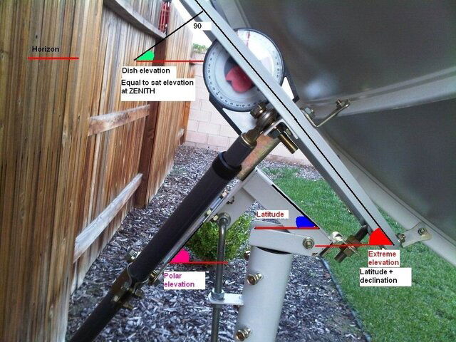
My Latitude is 50.02 N and Longitude is 113.58 W. According to my paper work my elevation should be 32.70 with a declination of 6.62. My question is am I right in adding the elevation and declination together which comes to 39.32 and this is the angle across the face of the dish. I don't want to start ripping things apart if I am wrong.

Thanks for the help
 
Yes, that is correct, you add the declination angle to the elevation angle.

I usually place a straightedge "vertically" from the top outer edge to the bottom outer edge of the refelector when it is at apex, to measure that totalled angle.

I always use the declination angle from the "Modified" declination angle chart.
 
I wouldn't swap the bolts, that's too much work. Just get a threaded collar to extend the length of your declination bolt. Think of it as an extra long "nut", and it screws onto the dec. bolt. Then, you screw some all-thread rod into the other end, and put it into the spot the old declination bolt end used to go into. That way you don't have all the work of tearing apart your polar mount, which has the potential to cause you great heartache if something goes wrong.
 
Think you may be confused by the perpendiculars of the angles. Hope this helps. reference the attached picture.
Latitude 50.02 (.02 dropped)
Using the "Modified Declination"** angles
Polar axis (Latitude) angle 50.64
Polar axis perpendicular (90 - 50.64) = 39.36
Declination angle** 6.67
Dish (Latitude + Declination) angle 50.64 + 6.64 = 57.28
Elevation to arc at zenith at latitude 50 = the perpendicular of the dish angle at zenith.
90 - 57.28 = 32.72
(checking dishpointer confirmation - any longitude can be used -
Latitude: 50.0000°
Longitude: -97.0000°
Name: 97W GALAXY 19 (G-19)
Distance: 38379km
Elevation: 32.7°
Azimuth (true): 180.0°
(Even if we were to set the polar axis angle to your latitude it would be less than 1° . Close enough to start)
 

Attachments

  • polar_mount_pic.jpg
    polar_mount_pic.jpg
    152.6 KB · Views: 177
Thanks for that explanation FaT Air.

Using the terminology from your picture, the angles that I add (using the "Modified" table) are Latitude Angle + Declination Angle = Extreme Elevation, and that is the figure I look for on my digital angle meter or inclinometer on my straightedge.

Must be doing something right, I always get them to track the arc (BV Spoons notwithstanding). ;)

Nosbod, study FA's pic, the perpendiculars of the angles can be a little confusing but he has it all layed out in that pic.
 
Status
Please reply by conversation.

Users Who Are Viewing This Thread (Total: 0, Members: 0, Guests: 0)

Who Read This Thread (Total Members: 1)