How do I get started

Status
Please reply by conversation.
Yes, I use one similar to that one. Remember if you own a smart phone you can get apps that will work also. Just do some testing with known angles to make sure it is accurate.
The nice thing about those cubes is, they are small. Your phone may be a good stopgap though.
 
By the looks of it my numbers are way off. I need to figure out where to put the meter so I can get accurate numbers because it changes every time I move up or down the mount.
 

Attachments

  • IMG_1489.JPG
    IMG_1489.JPG
    33.7 KB · Views: 160
  • IMG_1490.JPG
    IMG_1490.JPG
    49 KB · Views: 168
  • IMG_1493.JPG
    IMG_1493.JPG
    54.2 KB · Views: 180
  • IMG_1494.JPG
    IMG_1494.JPG
    73.8 KB · Views: 172
Set my elevation to 38.2 and declination to 44.3 and still not getting a lock on anything. I'll try again tomorrow since it's time for me to head to work
 
38.2 degrees elevation puts you at 51.8 N latitude. If you are in the lower '48 those numbers are off. Declination would be a single digit degree like 4 to 7 degrees, so if your declination is 6.1 degrees that does put you fairly far north, maybe 48-ish deg latitude? Then your elevation should be around 42 deg.

90 - your latitude deg = your elevation deg. Once you get that set then adjust the declination.

Can't wait to hear you have picked up your first signal! :)
 
This is what dishpointer it's tell me how to set up unless I'm reading it wrong. My location is fort branch Indiana
 

Attachments

  • IMG_1474.PNG
    IMG_1474.PNG
    87.7 KB · Views: 151
Well, your scale is called 'coarse latitude', so it is correct to set that to about 38.2.
The 'elevation' then is (90-38.2=) 51.8, however.
(Terminology IS important! :) Or you will confuse us...)

I cannot understand from your photos how you set 'fine latitude' with your mount, though.
Do I understand right that you set fine latitude together with dish declination?

Why not measure final dish-angle at the face of the dish (with a wooden plank or so)?
Elevation of total mount+dish should be 51.8 - 6.1 = 45.7 degrees (0 degrees = towards horizon; 90 degrees = towards sky.)

Hope this helps?

greetz,
A33
 
Okay I think I got this, so I messed my elevation by setting it at 38.2 when I really should had set it at 45.7
The 38.2 is for getting the declination for my area which would be the 6.1
So I need the move the dish elevation to 45.7 and I shouldnt half to mess with the declination since I got that set already but verify it's still set right.
 
The turning axis of the mount should be elevated 51.8 degrees from horizontal. On the scale it should be 38.2, therefore.
(Assuming the pole is absolutely plumb, and you set the turning axis exactly south of the pole.)
First see to it, that that is absolutely right. Forget about declination/dish-elevation for the moment!

From your pictures I would assume that your mount elevation is now about 41 degrees (towards vertical, I would guess).

How is the fineadjustment for this mount-elevation constructed? Is it with both the two bolts, visible in the right/under quadrant of your picture 1494.jpg?
Edit: Or is it below the coarse setting bolt, just UNDER the picture 1485.jpg?

I don't know if you can adjust below the coarse setting of 40 degrees latitude. If not, you have to set the coarse setting at 30 degrees, and add the 8.2 degrees in the fine setting.

Do you understand the 'manuals', linked in this topic, so far? You still seem full of puzzles.

Greetz,
A33
 
There we go, location is important! 38.2 latitude equals 51.8 degrees elevation for your polar axis (axle where your mount turns); as A33 pointed out above. :)

edit: use the course adjustment 40 deg latitude position and adjust the fine screw so your incinometer says 51.8 deg.elevation. (incinometer should be zeroed when horizontal).

Picture 1487 shows declination adjustment. It should be set to your latitude which is 38.2 deg. Once set your dish "should" be in the ballpark if the markings are accurate on the decals.
 
Last edited:
I've read the manuals and I'm still confused on setting this thing. Doesn't make matters better that the mount is very hard to adjust, even the manual on this forum for the dish shows a different fine adjustment elevation bolt. I readjusted the dish to 45.7 elevation and with the 6.1 declination I'm getting 51.8 on my inclinometer when on put it on the back of the buttonhook plate on the dish. I'm still not receiving anything and yes my pole is plum. I need to get this thing working soon before it has to come down and taken to the dump.
 
Find polar axis in this .pdf drawing:

https://www.satelliteguys.us/xen/attachments/page06-pdf.54152/

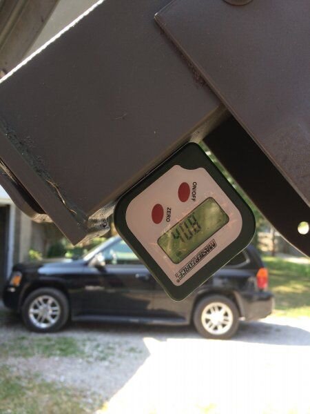
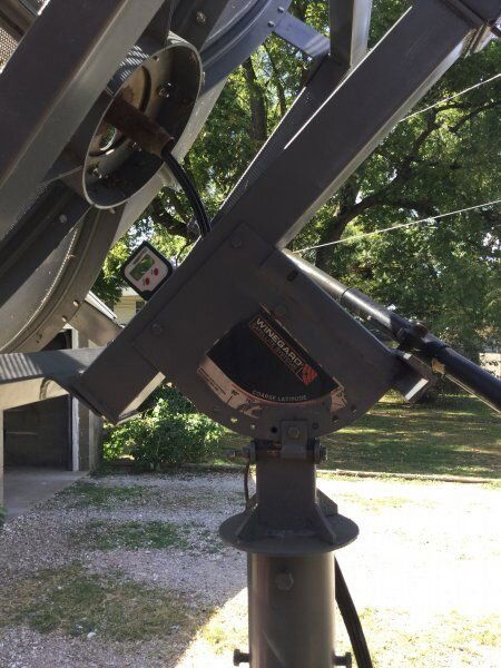
The 51.8 degrees should be read on the polar mount mount axis, not the dish itself. Look at the line in the image and set your incinometer on that axis somehow on the part that does not move with the dish. That should read 51.8 degrees of elevation compared to the horizon. It should be close to this angle as possible, but you will likely end up moving it again to fine-tune once you get a signal.

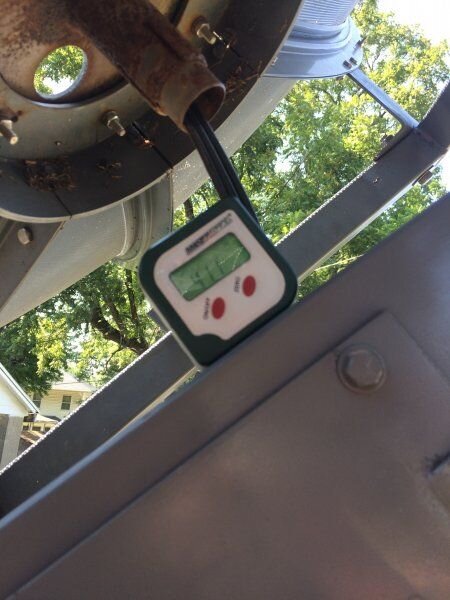
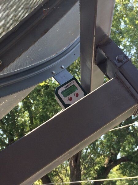
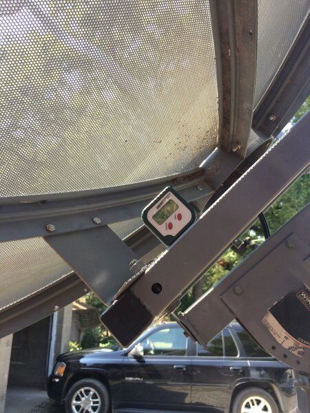
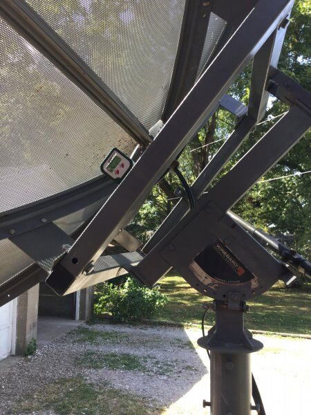
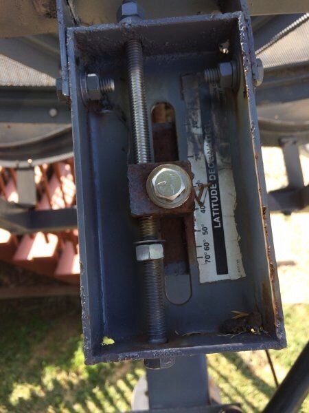
Now adjust the declination (dish look angle in the diagram) to show your latitude- (38.2deg). If properly adjusted your dish should point 6.1 deg lower than your polar axis angle, and show 45.7 deg elevation on the back plate of your button-hook plate or rear dish surface. In that picture #1407, the increments are not in degrees of declination, but are indicating latitude, so when you have adjusted for your latitude at 38.2 you "should" get close to your 6.1 deg declination.

I really wish I were closer, 1000mi 1-way drive is just not in the cards right now. Maybe there is someone nearby that can help??

If your receiver is hooked up to a monitor near your dish, feedline running to your LNBF, and your receiver has a good transponder programmed in for your true-south satellite, VERY slowly move your dish east and west from center. You will get a good signal all the time, but no quality until you are pointed at a satellite with the indicated transponder. If Quality jumps up, you have found a signal. Good luck!!!

Credit:
PDF image link was taken from FaT Air's BUD installation manual at the top pf the C-band sub forum (sticky).
BUD manual
 
So if I understand this right this is my polar axis and I currently have it set at 45.6 so I need to set that to 51.8 which would mean I need to move the coarse latitude bolt from 40 to the 50 and fine tune to 51.8 correct?
 

Attachments

  • image.jpg
    image.jpg
    64.4 KB · Views: 137
How do I set the declination on this thing? All I seem to be doing is bending the sh*t out of the bolt
 

Attachments

  • image.jpg
    image.jpg
    44.4 KB · Views: 131
So if I understand this right this is my polar axis and I currently have it set at 45.6 so I need to set that to 51.8 which would mean I need to move the coarse latitude bolt from 40 to the 50 and fine tune to 51.8 correct?

Yes to 51.8 degree ELEVATION, that is 51.8 degrees difference towards the (horizontal) horizon.
You keep mentioning degrees, without saying degrees relevant to horizon or relevant to vertical line. That way, we cannot follow which angle you mean.
0 Latitude means 90 elevation; 90 latitude means 0 elevation.

I guess your measured value of 45.6 is elevation towards horizon (as it was first around 41 in earlier pictures).
Now that your fine-latitude bolt is better visible on your photo, it can be seen that you probably will not reach 38lat/51elev with the fine adjustment.
So set the coarse latitude to 30 (I mentioned earlier that that would probably be needed), and then fineadjust to 38lat/51elev.
Don't set it to 50, as you mention, as the scale is in Latitude!, so you must use 30.

As for dish position: yes that would be correct (assuming the dish face is exactly parallel to the spot where you want to measure. Edit: But I am not sure about that at all!).

Greetz,
A33
 
How do I set the declination on this thing? All I seem to be doing is bending the sh*t out of the bolt

You don't touch it, before the mount's axis angle is absolutely right! :rolleyes::rolleyes::rolleyes::rolleyes::rolleyes::rolleyes::rolleyes::rolleyes::rolleyes:
:rolleyes::rolleyes::rolleyes::rolleyes::rolleyes::rolleyes::rolleyes::rolleyes::rolleyes:


After that, you wait a bit. You got to do this step by step.

After that, you loosen the top (axis-) bolt first i guess?

A33
 
I guess we're im getting confused is the course latitude your saying need to be at 38.2 and my elevation needs to be 51.7 but my course latitude appears to be the only way to set my elevation
 
Status
Please reply by conversation.

Users Who Are Viewing This Thread (Total: 0, Members: 0, Guests: 0)

Who Read This Thread (Total Members: 2)