Arc Problems

  • WELCOME TO THE NEW SERVER!

    If you are seeing this you are on our new server WELCOME HOME!

    While the new server is online Scott is still working on the backend including the cachine. But the site is usable while the work is being completes!

    Thank you for your patience and again WELCOME HOME!

    CLICK THE X IN THE TOP RIGHT CORNER OF THE BOX TO DISMISS THIS MESSAGE
Status
Please reply by conversation.
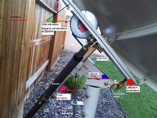
It does not look like the Dish is at the Highest Point for South Sat - looks to be pointing a little too far west.
I would drive the Dish to it's highest point, adjust azimuth back to 87west, adjust elevation to peak signal, then check a Sat to the West and East.
 
Remember to make small adjustments. First elevation, then azimuth, then repeat. It takes a while but in the end it will be worth it.
 
North Liberty is 41.533575,-86.429371 so I agree, dish is too far west. move it to 'center' and peak up Q by twisting the mount on the pole, then Elevation. 'Lock' the elevation adjustment. Then fine tune the azimuth (twist of mount on pole and actuator) to max Q on the E or Western satellites.
Where did the dish come from, How many miles N or S of it's present location??
Measure the declination angle? (actually calculate, as the dish face and polar mount are measured, Declination is the difference)
 

Attachments

  • 20054.jpg
    20054.jpg
    47.9 KB · Views: 101
Very Important to remember: the polar mount at its highest elevation is pointing due true south!

if you have any obstructions after you set the elevation and declination bolts for "your spot on the map" using a inclinometer (i use an iphone ap) then the arc is the signals achieved!

Now look at eastern satellites; then far western ones; are there any obstructions? Are the signals beefy?

A Prodelin is so good at receiving it is to accurate; and its beamwidth is way less than 2 degrees; any adjustment even very small will affect it greatly. A prodelin can be installed upside down on the mount and never track the arc (declination adding against itself) then arcing cannot be achieved because it was assembled wrong!).
 
Last edited:
Much better - :up
Just a thought. May want to move the actuator to the other side, so there's no chance of 'flopping' the dish when you move to the Atlantic satellites... 139w isn't as far west as 40w is east.
 
Due to the mechanical design of a polar type mount, once the dish travels past a point traveling in the direction opposite side of where the actuator is mounted, the dish flops.

Place the actuator on the side of the arc that has the lowest elevation satellites. This way the motor is pushing up from the lowest satellite position and can be aimed to satellites that are lower in elevation on that side of the arc.


Brian Gohl
Titanium Satellite
 
Last edited:
Because BITD most the satellites of interest, those with the subscription channels, were in the western sky. Basically 137 to 97. Very few channels were east of there.
 
I checked on dishpointer.com and the farthest east I will be able to track is 40.5W. I know I'm going to need a bigger actuator to track 40.5W-139W. Will I be able to track this with the actuator on the other side and with the dish flopping?
 
Once you get it tracking, with the actuator as mounted, do not be concerned about 40.5w to 139.
If not already done, move the actuator to the east side of the pole.
Then retract the actuator to within 1/4 inch of bottoming out.
Then adjust the actuator in the fixed mount to acquire 40.5w.
Then extend the actuator to see 'how far W you get' to determine if a longer actuator is necessary.
From the looks of it, it's a 24 inch, that should work just fine.

Be aware, some C band sats E of 55W use circular polarity.

Maybe, down the 'road' might be advantageous to 'sidewinder'/'siamese' a 2nd LNBF with the dielectric plate installed onto the side of the linear LNBF. I'd put it on the west side as that would make it look east more.
 
If you are having problems tracking the arc, I suggest you get a digital inclinometer and set the elevation and declination angles precisely, rather than guessing. Don't use an analog inclinometer, it isn't precise enough. If you are off by even 1-2 degrees on the elevation or declination, it will be difficult to track the arc, especially low in the horizon.

I recently installed an 8ft mesh dish and can track the arc perfectly from 37.4W to 137W. If I can do it, you should be able to do it also. It isn't rocket science - you just need the right tool.
 
Status
Please reply by conversation.